Flat Rock Topo Map Alabama
To zoom in, hover over the map of Flat Rock
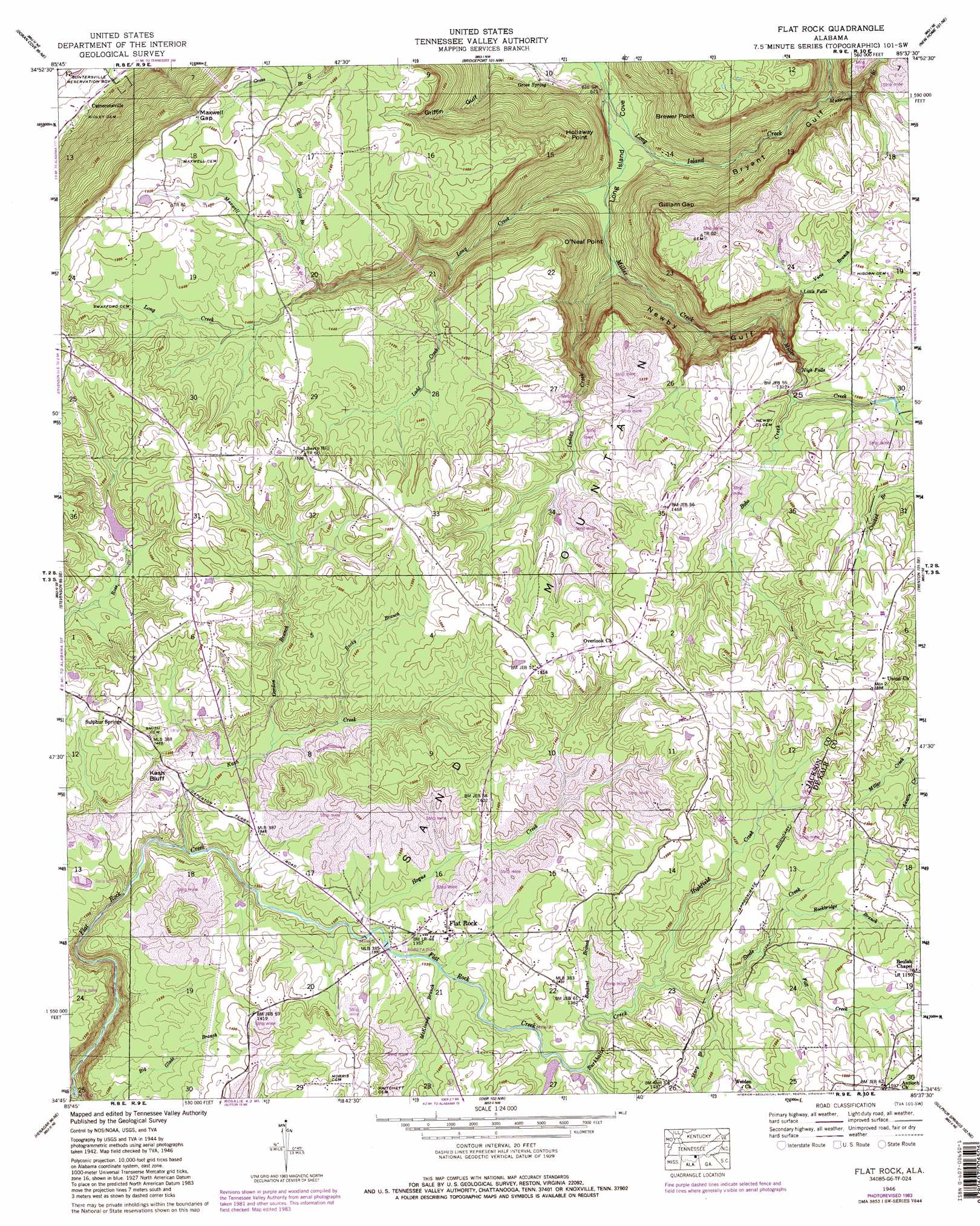
USGS Topo Quad 34085g6 - 1:24,000 scale
| Topo Map Name: | Flat Rock |
| USGS Topo Quad ID: | 34085g6 |
| Print Size: | ca. 21 1/4" wide x 27" high |
| Southeast Coordinates: | 34.75° N latitude / 85.625° W longitude |
| Map Center Coordinates: | 34.8125° N latitude / 85.6875° W longitude |
| U.S. State: | AL |
| Filename: | o34085g6.jpg |
| Download Map JPG Image: | Flat Rock topo map 1:24,000 scale |
| Map Type: | Topographic |
| Topo Series: | 7.5´ |
| Map Scale: | 1:24,000 |
| Source of Map Images: | United States Geological Survey (USGS) |
| Alternate Map Versions: |
Flat Rock AL 1936 Download PDF Buy paper map Flat Rock AL 1946, updated 1947 Download PDF Buy paper map Flat Rock AL 1946, updated 1956 Download PDF Buy paper map Flat Rock AL 1946, updated 1974 Download PDF Buy paper map Flat Rock AL 1946, updated 1975 Download PDF Buy paper map Flat Rock AL 1946, updated 1983 Download PDF Buy paper map Flat Rock AL 1946, updated 1983 Download PDF Buy paper map Flat Rock AL 2011 Download PDF Buy paper map Flat Rock AL 2014 Download PDF Buy paper map |
1:24,000 Topo Quads surrounding Flat Rock
Sinking Cove |
Orme |
South Pittsburg |
Sequatchie |
Wauhatchie |
Eureka |
Doran Cove |
Bridgeport |
New Home |
Hooker |
Wannville |
Stevenson |
Flat Rock |
Trenton |
Durham |
Hollywood |
Henagar |
Ider |
Sulphur Springs |
Cedar Grove |
Dutton |
Sylvania |
Dugout Valley |
Valley Head |
Dougherty Gap |
> Back to 34085e1 at 1:100,000 scale
> Back to 34084a1 at 1:250,000 scale
> Back to U.S. Topo Maps home
Flat Rock topo map: Gazetteer
Flat Rock: Bridges
Flat Rock Bridge elevation 403m 1322′Flat Rock: Capes
Brewer Point elevation 429m 1407′Hollaway Point elevation 405m 1328′
O'Neal Point elevation 418m 1371′
Flat Rock: Cliffs
Kash Bluff elevation 433m 1420′Flat Rock: Dams
Fort Mountain State Park Dam elevation 437m 1433′Mansel Wolf Dam elevation 427m 1400′
Robert Shrader Dam elevation 421m 1381′
Flat Rock: Falls
High Falls elevation 373m 1223′Little Falls elevation 393m 1289′
Flat Rock: Gaps
Gilliam Gap elevation 389m 1276′Maxwell Gap elevation 441m 1446′
Flat Rock: Populated Places
Cameronsville elevation 197m 646′Fairview elevation 462m 1515′
Flat Rock elevation 416m 1364′
Liberty Hill elevation 463m 1519′
Overlook elevation 463m 1519′
Sulphur Springs elevation 457m 1499′
Flat Rock: Reservoirs
Fort Mountain Lake elevation 437m 1433′Mansel Wolf Lake elevation 427m 1400′
Robert Shrader Lake elevation 421m 1381′
Flat Rock: Springs
Gross Spring elevation 208m 682′Flat Rock: Streams
Bobo Creek elevation 392m 1286′Bookout Branch elevation 402m 1318′
Burkhalter Creek elevation 402m 1318′
Fall Creek elevation 417m 1368′
Flat Rock Creek elevation 290m 951′
Gordon Branch elevation 394m 1292′
Gray Branch elevation 393m 1289′
Guest Creek elevation 283m 928′
Higdon Creek elevation 402m 1318′
Highfield Creek elevation 406m 1332′
Hogue Creek elevation 391m 1282′
Kash Creek elevation 371m 1217′
Ladd Creek elevation 319m 1046′
Long Creek elevation 195m 639′
Mary Branch elevation 421m 1381′
Maxwell Branch elevation 428m 1404′
McKinney Branch elevation 401m 1315′
Miller Creek elevation 189m 620′
Muscrowe Branch elevation 283m 928′
Pond Creek elevation 290m 951′
Rockbridge Branch elevation 426m 1397′
Rocky Branch elevation 396m 1299′
Sanka Branch elevation 315m 1033′
Steele Creek elevation 408m 1338′
Vicie Branch elevation 285m 935′
Flat Rock: Valleys
Bryant Gulf elevation 196m 643′Griffin Gulf elevation 202m 662′
Newby Gulf elevation 206m 675′
Flat Rock digital topo map on disk
Buy this Flat Rock topo map showing relief, roads, GPS coordinates and other geographical features, as a high-resolution digital map file on DVD: