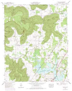
Wannville Topo Map Alabama
To zoom in, hover over the map of Wannville
USGS Topo Quad 34085g8 - 1:24,000 scale
| Topo Map Name: | Wannville |
| USGS Topo Quad ID: | 34085g8 |
| Print Size: | ca. 21 1/4" wide x 27" high |
| Southeast Coordinates: | 34.75° N latitude / 85.875° W longitude |
| Map Center Coordinates: | 34.8125° N latitude / 85.9375° W longitude |
| U.S. State: | AL |
| Filename: | o34085g8.jpg |
| Download Map JPG Image: | Wannville topo map 1:24,000 scale |
| Map Type: | Topographic |
| Topo Series: | 7.5´ |
| Map Scale: | 1:24,000 |
| Source of Map Images: | United States Geological Survey (USGS) |
| Alternate Map Versions: |
Wannville AL 1936 Download PDF Buy paper map Wannville AL 1947, updated 1972 Download PDF Buy paper map Wannville AL 1947, updated 1972 Download PDF Buy paper map Wannville AL 1950, updated 1950 Download PDF Buy paper map Wannville AL 2011 Download PDF Buy paper map Wannville AL 2014 Download PDF Buy paper map |
1:24,000 Topo Quads surrounding Wannville
> Back to 34085e1 at 1:100,000 scale
> Back to 34084a1 at 1:250,000 scale
> Back to U.S. Topo Maps home
Wannville topo map: Gazetteer
Wannville: Bridges
Renshaw Bridge elevation 183m 600′Wannville: Capes
Indian Point elevation 457m 1499′Inglis Point elevation 252m 826′
Russell Point elevation 414m 1358′
Wilson Point elevation 458m 1502′
Wannville: Gaps
Low Gap elevation 247m 810′Saddle Gap elevation 409m 1341′
Wannville: Lakes
Dudley Pond elevation 188m 616′Horseshoe Pond elevation 186m 610′
Wannville: Parks
Russells Track elevation 187m 613′Samuel Key Reservation elevation 192m 629′
William Key Reservation elevation 187m 613′
Wannville: Populated Places
Carns elevation 190m 623′Fackler elevation 186m 610′
Fairfield (historical) elevation 195m 639′
Rash elevation 196m 643′
Wannville elevation 187m 613′
Wannville: Ridges
Garner Ridge elevation 331m 1085′Stewart Ridge elevation 255m 836′
Wannville: Springs
Blue Spring elevation 189m 620′Blue Spring elevation 184m 603′
Houston Spring elevation 191m 626′
Kyles Spring elevation 186m 610′
Wannville: Streams
Big Coon Creek elevation 183m 600′Blue Spring Brook elevation 181m 593′
Houston Branch elevation 183m 600′
Inglis Branch elevation 189m 620′
Little Coon Creek elevation 183m 600′
Owen Branch elevation 181m 593′
Wannville: Summits
Dudley Pond Mountain elevation 395m 1295′Poorhouse Mountain elevation 427m 1400′
Russell Mountain elevation 459m 1505′
Walker Mountain elevation 291m 954′
Wannville: Valleys
Allison Hollow elevation 209m 685′Big Coon Valley elevation 183m 600′
Brewster Hollow elevation 183m 600′
Carns Cove elevation 186m 610′
Goshen Hollow elevation 211m 692′
Hammon Hollow elevation 200m 656′
Happy Hollow elevation 186m 610′
Inglis Hollow elevation 198m 649′
Owl Hollow elevation 190m 623′
Roach Cove elevation 183m 600′
Stogsdill Cove elevation 192m 629′
Washington Cove elevation 186m 610′
Womack Hollow elevation 188m 616′
Wannville digital topo map on disk
Buy this Wannville topo map showing relief, roads, GPS coordinates and other geographical features, as a high-resolution digital map file on DVD:


