Bridgeport Topo Map Alabama
To zoom in, hover over the map of Bridgeport
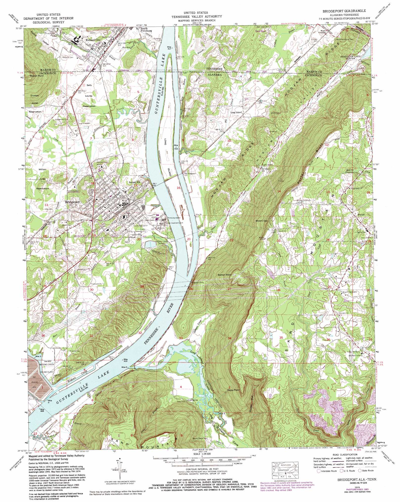
USGS Topo Quad 34085h6 - 1:24,000 scale
| Topo Map Name: | Bridgeport |
| USGS Topo Quad ID: | 34085h6 |
| Print Size: | ca. 21 1/4" wide x 27" high |
| Southeast Coordinates: | 34.875° N latitude / 85.625° W longitude |
| Map Center Coordinates: | 34.9375° N latitude / 85.6875° W longitude |
| U.S. States: | AL, TN |
| Filename: | o34085h6.jpg |
| Download Map JPG Image: | Bridgeport topo map 1:24,000 scale |
| Map Type: | Topographic |
| Topo Series: | 7.5´ |
| Map Scale: | 1:24,000 |
| Source of Map Images: | United States Geological Survey (USGS) |
| Alternate Map Versions: |
Bridgeport AL 1936 Download PDF Buy paper map Bridgeport AL 1945 Download PDF Buy paper map Bridgeport AL 1945, updated 1964 Download PDF Buy paper map Bridgeport AL 1945, updated 1974 Download PDF Buy paper map Bridgeport AL 1946 Download PDF Buy paper map Bridgeport AL 1974, updated 1977 Download PDF Buy paper map Bridgeport AL 1974, updated 1986 Download PDF Buy paper map Bridgeport AL 2010 Download PDF Buy paper map Bridgeport AL 2011 Download PDF Buy paper map Bridgeport AL 2014 Download PDF Buy paper map |
1:24,000 Topo Quads surrounding Bridgeport
Sewanee |
Monteagle |
White City |
Whitwell |
Ketner Gap |
Sinking Cove |
Orme |
South Pittsburg |
Sequatchie |
Wauhatchie |
Eureka |
Doran Cove |
Bridgeport |
New Home |
Hooker |
Wannville |
Stevenson |
Flat Rock |
Trenton |
Durham |
Hollywood |
Henagar |
Ider |
Sulphur Springs |
Cedar Grove |
> Back to 34085e1 at 1:100,000 scale
> Back to 34084a1 at 1:250,000 scale
> Back to U.S. Topo Maps home
Bridgeport topo map: Gazetteer
Bridgeport: Airports
Indian Hill Farm Airport elevation 198m 649′Bridgeport: Bars
Bridgeport Bar elevation 181m 593′Hembrees Bar elevation 181m 593′
Island Bar elevation 181m 593′
Upper Bar elevation 181m 593′
Upper Bar elevation 181m 593′
Widows Bar elevation 181m 593′
Bridgeport: Capes
Barton Point elevation 479m 1571′Hicks Point elevation 444m 1456′
Rexton Point elevation 463m 1519′
Bridgeport: Cliffs
Porter Bluff elevation 497m 1630′Bridgeport: Crossings
Island Creek Ferry (historical) elevation 181m 593′Reese Ferry elevation 181m 593′
Bridgeport: Gaps
Bryant Gap elevation 467m 1532′Bridgeport: Islands
Long Island elevation 186m 610′Long Island elevation 186m 610′
Bridgeport: Lakes
Blue Hole elevation 185m 606′Bridgeport: Parks
Bridgeport Community Park elevation 187m 613′Sally Lourey Reservation elevation 189m 620′
Bridgeport: Populated Places
Battery Hill elevation 220m 721′Bridgeport elevation 205m 672′
Bryant elevation 497m 1630′
Copenhagen (historical) elevation 189m 620′
Long Island elevation 197m 646′
Richard City elevation 193m 633′
Bridgeport: Post Offices
Rock Spring Post Office (historical) elevation 202m 662′Bridgeport: Ridges
Hogjaw Ridge elevation 293m 961′Hogjaw Ridge elevation 247m 810′
Bridgeport: Springs
Gray Spring elevation 190m 623′Bridgeport: Streams
Big Culvert Creek elevation 182m 597′Crooked Branch elevation 181m 593′
Glover Creek elevation 181m 593′
Graham Branch elevation 189m 620′
Gross Branch elevation 182m 597′
Horn Branch elevation 183m 600′
Irondale Branch elevation 185m 606′
Jones Creek elevation 182m 597′
Lary Creek elevation 434m 1423′
Lively Creek elevation 303m 994′
Long Hollow Branch elevation 188m 616′
Long Hollow Branch elevation 182m 597′
Long Island Creek elevation 181m 593′
Poplar Spring Branch elevation 181m 593′
Widows Creek elevation 181m 593′
Bridgeport: Valleys
Gibson Cove elevation 181m 593′Hogjaw Valley elevation 185m 606′
King Cove elevation 188m 616′
Long Island Cove elevation 181m 593′
Patton Hollow elevation 203m 666′
Rhodes Gulf elevation 194m 636′
Bridgeport digital topo map on disk
Buy this Bridgeport topo map showing relief, roads, GPS coordinates and other geographical features, as a high-resolution digital map file on DVD: