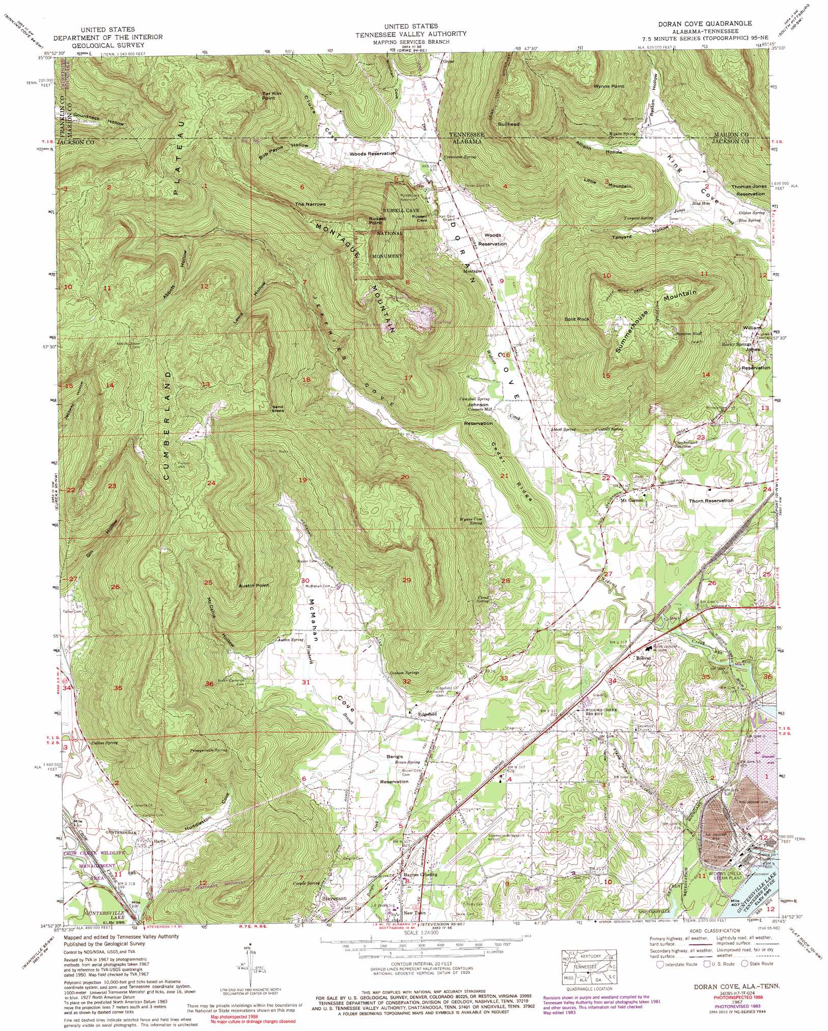
Doran Cove Topo Map Alabama
To zoom in, hover over the map of Doran Cove
USGS Topo Quad 34085h7 - 1:24,000 scale
| Topo Map Name: | Doran Cove |
| USGS Topo Quad ID: | 34085h7 |
| Print Size: | ca. 21 1/4" wide x 27" high |
| Southeast Coordinates: | 34.875° N latitude / 85.75° W longitude |
| Map Center Coordinates: | 34.9375° N latitude / 85.8125° W longitude |
| U.S. States: | AL, TN |
| Filename: | o34085h7.jpg |
| Download Map JPG Image: | Doran Cove topo map 1:24,000 scale |
| Map Type: | Topographic |
| Topo Series: | 7.5´ |
| Map Scale: | 1:24,000 |
| Source of Map Images: | United States Geological Survey (USGS) |
| Alternate Map Versions: |
Doran Cove AL 1936 Download PDF Buy paper map Doran Cove AL 1950 Download PDF Buy paper map Doran Cove AL 1967, updated 1972 Download PDF Buy paper map Doran Cove AL 1967, updated 1985 Download PDF Buy paper map Doran Cove AL 1967, updated 1991 Download PDF Buy paper map Doran Cove AL 1967, updated 1991 Download PDF Buy paper map Doran Cove AL 2010 Download PDF Buy paper map Doran Cove AL 2011 Download PDF Buy paper map Doran Cove AL 2014 Download PDF Buy paper map |
1:24,000 Topo Quads surrounding Doran Cove
Winchester |
Sewanee |
Monteagle |
White City |
Whitwell |
Pitcher Ridge |
Sinking Cove |
Orme |
South Pittsburg |
Sequatchie |
Hytop |
Eureka |
Doran Cove |
Bridgeport |
New Home |
Mud Creek |
Wannville |
Stevenson |
Flat Rock |
Trenton |
Scottsboro |
Hollywood |
Henagar |
Ider |
Sulphur Springs |
> Back to 34085e1 at 1:100,000 scale
> Back to 34084a1 at 1:250,000 scale
> Back to U.S. Topo Maps home
Doran Cove topo map: Gazetteer
Doran Cove: Airports
Stevenson-Bridgeport Municipal Airport elevation 192m 629′Doran Cove: Capes
Austin Point elevation 471m 1545′Tar Kiln Point elevation 513m 1683′
Wynne Point elevation 455m 1492′
Doran Cove: Cliffs
Russell Point elevation 504m 1653′Sand Steps elevation 476m 1561′
Split Rock elevation 447m 1466′
Doran Cove: Crossings
Ridleys Ferry (historical) elevation 180m 590′Doran Cove: Dams
Widows Bar Lock and Dam (historical) elevation 180m 590′Doran Cove: Gaps
The Narrows elevation 489m 1604′Doran Cove: Mines
Baugh Mine elevation 491m 1610′Montague Mines elevation 469m 1538′
Tennessee Valley Mine elevation 455m 1492′
Walker and Leonard Mine elevation 536m 1758′
Doran Cove: Parks
Bengis Reservation elevation 192m 629′Johnson Reservation elevation 187m 613′
Russell Cave National Monument elevation 205m 672′
Thomas Jones Reservation elevation 198m 649′
Thorn Reservation elevation 195m 639′
William Jones Reservation elevation 202m 662′
Woods Reservation elevation 214m 702′
Doran Cove: Populated Places
Bolivar elevation 190m 623′Browns Valley (historical) elevation 214m 702′
Coopers Mill elevation 191m 626′
Cumberland Junction elevation 200m 656′
Edgefield elevation 197m 646′
Harris elevation 192m 629′
Haynes Crossing elevation 188m 616′
Montague elevation 193m 633′
Mount Carmel elevation 196m 643′
Rocky Springs elevation 225m 738′
Summer Bluff elevation 458m 1502′
Widows Creek Station elevation 190m 623′
Doran Cove: Ridges
Cedar Ridge elevation 231m 757′Doran Cove: Springs
Abbott Spring elevation 197m 646′Austin Spring elevation 201m 659′
Blue Hole elevation 192m 629′
Blue Spring elevation 189m 620′
Brown Spring elevation 189m 620′
Campbell Spring elevation 187m 613′
Cantrell Spring elevation 201m 659′
Cargile Spring elevation 205m 672′
Cloud Spring elevation 212m 695′
Collins Spring elevation 185m 606′
Crownover Spring elevation 206m 675′
Gildan Spring elevation 190m 623′
Graham Springs elevation 201m 659′
Pennywinkle Spring elevation 311m 1020′
Rock Springs elevation 235m 770′
Tanyard Spring elevation 200m 656′
Wynne Cave Spring elevation 206m 675′
Wynne Spring elevation 205m 672′
Doran Cove: Streams
Chuck Cove Branch elevation 203m 666′Dry Creek elevation 207m 679′
Dry Creek elevation 200m 656′
Rexton Hollow Creek elevation 204m 669′
Russel Prong elevation 203m 666′
Wildcat Cove Branch elevation 203m 666′
Wimberly Branch elevation 188m 616′
Doran Cove: Summits
Bullhead elevation 519m 1702′Little Mountain elevation 358m 1174′
Montague Mountain elevation 506m 1660′
Summerhouse Mountain elevation 481m 1578′
Doran Cove: Trails
River Mont Cave Historical Trail elevation 445m 1459′Doran Cove: Valleys
Abbott Hollow elevation 313m 1026′Allison Hollow elevation 201m 659′
Allison Hollow elevation 201m 659′
Bob Payne Hollow elevation 236m 774′
Cluck Cove elevation 209m 685′
Doran Cove elevation 190m 623′
Gin Hollow elevation 196m 643′
Huddleston Cove elevation 188m 616′
Jeffries Cove elevation 185m 606′
Lewis Hollow elevation 261m 856′
McCallie Hollow elevation 213m 698′
McMahan Cove elevation 188m 616′
Rexton Hollow elevation 204m 669′
Tanyard Hollow elevation 192m 629′
Wildman Cove elevation 226m 741′
Doran Cove digital topo map on disk
Buy this Doran Cove topo map showing relief, roads, GPS coordinates and other geographical features, as a high-resolution digital map file on DVD: