Garden City Topo Map Alabama
To zoom in, hover over the map of Garden City
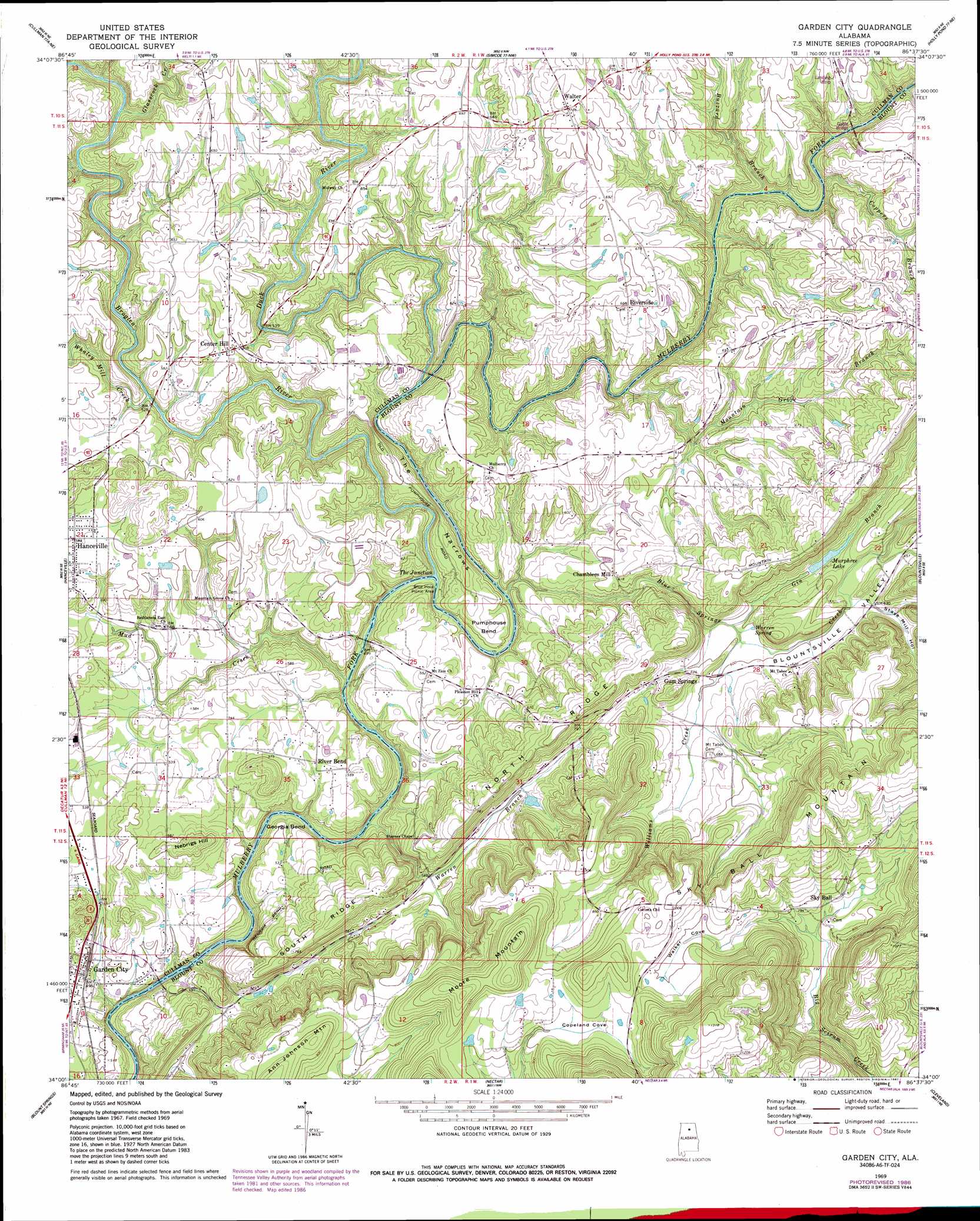
USGS Topo Quad 34086a6 - 1:24,000 scale
| Topo Map Name: | Garden City |
| USGS Topo Quad ID: | 34086a6 |
| Print Size: | ca. 21 1/4" wide x 27" high |
| Southeast Coordinates: | 34° N latitude / 86.625° W longitude |
| Map Center Coordinates: | 34.0625° N latitude / 86.6875° W longitude |
| U.S. State: | AL |
| Filename: | o34086a6.jpg |
| Download Map JPG Image: | Garden City topo map 1:24,000 scale |
| Map Type: | Topographic |
| Topo Series: | 7.5´ |
| Map Scale: | 1:24,000 |
| Source of Map Images: | United States Geological Survey (USGS) |
| Alternate Map Versions: |
Garden City AL 1969, updated 1972 Download PDF Buy paper map Garden City AL 1969, updated 1973 Download PDF Buy paper map Garden City AL 1969, updated 1987 Download PDF Buy paper map Garden City AL 1969, updated 1993 Download PDF Buy paper map Garden City AL 1975, updated 1977 Download PDF Buy paper map Garden City AL 2011 Download PDF Buy paper map Garden City AL 2014 Download PDF Buy paper map |
1:24,000 Topo Quads surrounding Garden City
Falkville |
Eva |
Lawrence Cove |
Hulaco |
Arab |
West Point |
Cullman |
Simcoe |
Holly Pond |
Brooksville |
Trimble |
Hanceville |
Garden City |
Blountsville |
Clarence |
Arkadelphia |
Blount Springs |
Nectar |
Cleveland |
Oneonta |
Creel |
Warrior |
Trafford |
Remlap |
Springville |
> Back to 34086a1 at 1:100,000 scale
> Back to 34086a1 at 1:250,000 scale
> Back to U.S. Topo Maps home
Garden City topo map: Gazetteer
Garden City: Bends
Georgia Bend elevation 128m 419′Pumphouse Bend elevation 172m 564′
Garden City: Dams
Murphree Lake Dam elevation 189m 620′Garden City: Gaps
The Narrows elevation 146m 479′Garden City: Populated Places
Center Hill elevation 184m 603′Chamblees Mill elevation 189m 620′
Garden City elevation 153m 501′
Gum Springs elevation 195m 639′
River Bend elevation 171m 561′
Riverside elevation 201m 659′
Sky Ball elevation 231m 757′
Steppville elevation 193m 633′
Walter elevation 219m 718′
Garden City: Post Offices
Garden City Post Office elevation 146m 479′Garden City: Reservoirs
Murphree Lake elevation 184m 603′Garden City: Ridges
North Ridge elevation 246m 807′Sky Ball Mountain elevation 311m 1020′
South Ridge elevation 236m 774′
Garden City: Springs
Warren Spring elevation 183m 600′Garden City: Streams
Blue Springs Creek elevation 146m 479′Broglen River elevation 142m 465′
Buzzard Branch elevation 157m 515′
Coppers Branch elevation 157m 515′
Duck River elevation 152m 498′
Gin Branch elevation 177m 580′
Glasscock Creek elevation 156m 511′
Goodson Branch elevation 157m 515′
Mountain Grove Branch elevation 151m 495′
Mud Creek elevation 136m 446′
Warren Branch elevation 134m 439′
Whaley Mill Creek elevation 157m 515′
Garden City: Summits
Moore Mountain elevation 344m 1128′Nebrigs Hill elevation 206m 675′
Garden City: Valleys
Blountsville Valley elevation 188m 616′Copeland Cove elevation 264m 866′
Long Cove elevation 231m 757′
Shamley Cove elevation 183m 600′
Stave Mill Hollow elevation 189m 620′
Walker Cove elevation 225m 738′
Garden City digital topo map on disk
Buy this Garden City topo map showing relief, roads, GPS coordinates and other geographical features, as a high-resolution digital map file on DVD: