Lawrence Cove Topo Map Alabama
To zoom in, hover over the map of Lawrence Cove
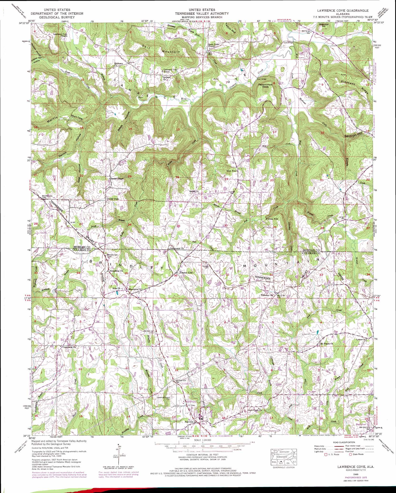
USGS Topo Quad 34086c6 - 1:24,000 scale
| Topo Map Name: | Lawrence Cove |
| USGS Topo Quad ID: | 34086c6 |
| Print Size: | ca. 21 1/4" wide x 27" high |
| Southeast Coordinates: | 34.25° N latitude / 86.625° W longitude |
| Map Center Coordinates: | 34.3125° N latitude / 86.6875° W longitude |
| U.S. State: | AL |
| Filename: | o34086c6.jpg |
| Download Map JPG Image: | Lawrence Cove topo map 1:24,000 scale |
| Map Type: | Topographic |
| Topo Series: | 7.5´ |
| Map Scale: | 1:24,000 |
| Source of Map Images: | United States Geological Survey (USGS) |
| Alternate Map Versions: |
Lawrence Cove AL 1936 Download PDF Buy paper map Lawrence Cove AL 1949, updated 1977 Download PDF Buy paper map Lawrence Cove AL 1951, updated 1951 Download PDF Buy paper map Lawrence Cove AL 2011 Download PDF Buy paper map Lawrence Cove AL 2014 Download PDF Buy paper map |
1:24,000 Topo Quads surrounding Lawrence Cove
Decatur |
Mason Ridge |
Triana |
Farley |
New Hope |
Hartselle |
Somerville |
Center Grove |
Newsome Sinks |
Guntersville Dam |
Falkville |
Eva |
Lawrence Cove |
Hulaco |
Arab |
West Point |
Cullman |
Simcoe |
Holly Pond |
Brooksville |
Trimble |
Hanceville |
Garden City |
Blountsville |
Clarence |
> Back to 34086a1 at 1:100,000 scale
> Back to 34086a1 at 1:250,000 scale
> Back to U.S. Topo Maps home
Lawrence Cove topo map: Gazetteer
Lawrence Cove: Bridges
Crow Bridge elevation 177m 580′Ryan Bridge elevation 182m 597′
Lawrence Cove: Falls
Welcome Falls elevation 261m 856′Lawrence Cove: Populated Places
Center Dale elevation 327m 1072′County Line elevation 317m 1040′
Fairview elevation 286m 938′
Lawrence Cove: Ridges
Pleasant Ridge elevation 318m 1043′Self Mountain elevation 323m 1059′
Lawrence Cove: Springs
Dry Creek Spring elevation 182m 597′Martin Spring elevation 181m 593′
Mud Creek Spring elevation 180m 590′
Persimmon Knob Spring elevation 182m 597′
Roan Spring elevation 190m 623′
Lawrence Cove: Streams
Albritton Creek elevation 195m 639′Dry Creek elevation 180m 590′
Fall Creek elevation 188m 616′
Ford Branch elevation 189m 620′
Frost Creek elevation 193m 633′
Herring Branch elevation 271m 889′
Keller Creek elevation 179m 587′
Kennedy Creek elevation 199m 652′
Kimbrell Branch elevation 271m 889′
Long Branch elevation 241m 790′
Mardis Branch elevation 272m 892′
McAnear Creek elevation 179m 587′
Minnow Creek elevation 262m 859′
Mud Creek elevation 177m 580′
Pied Creek elevation 236m 774′
Pruitt Branch elevation 264m 866′
Rock Creek elevation 180m 590′
Widner Creek elevation 188m 616′
Yarbrough Branch elevation 253m 830′
Lawrence Cove: Summits
Persimmon Knob elevation 289m 948′Sugarloaf Hill elevation 222m 728′
Lawrence Cove: Valleys
Bates Hollow elevation 188m 616′Copper Spring Hollow elevation 226m 741′
Derrick Hollow elevation 204m 669′
Goat Hollow elevation 216m 708′
Greasy Cove elevation 226m 741′
Lawrence Cove elevation 179m 587′
Martin Hollow elevation 189m 620′
Puckett Hollow elevation 228m 748′
Section Hollow elevation 179m 587′
Lawrence Cove digital topo map on disk
Buy this Lawrence Cove topo map showing relief, roads, GPS coordinates and other geographical features, as a high-resolution digital map file on DVD: