Mount Carmel Topo Map Alabama
To zoom in, hover over the map of Mount Carmel
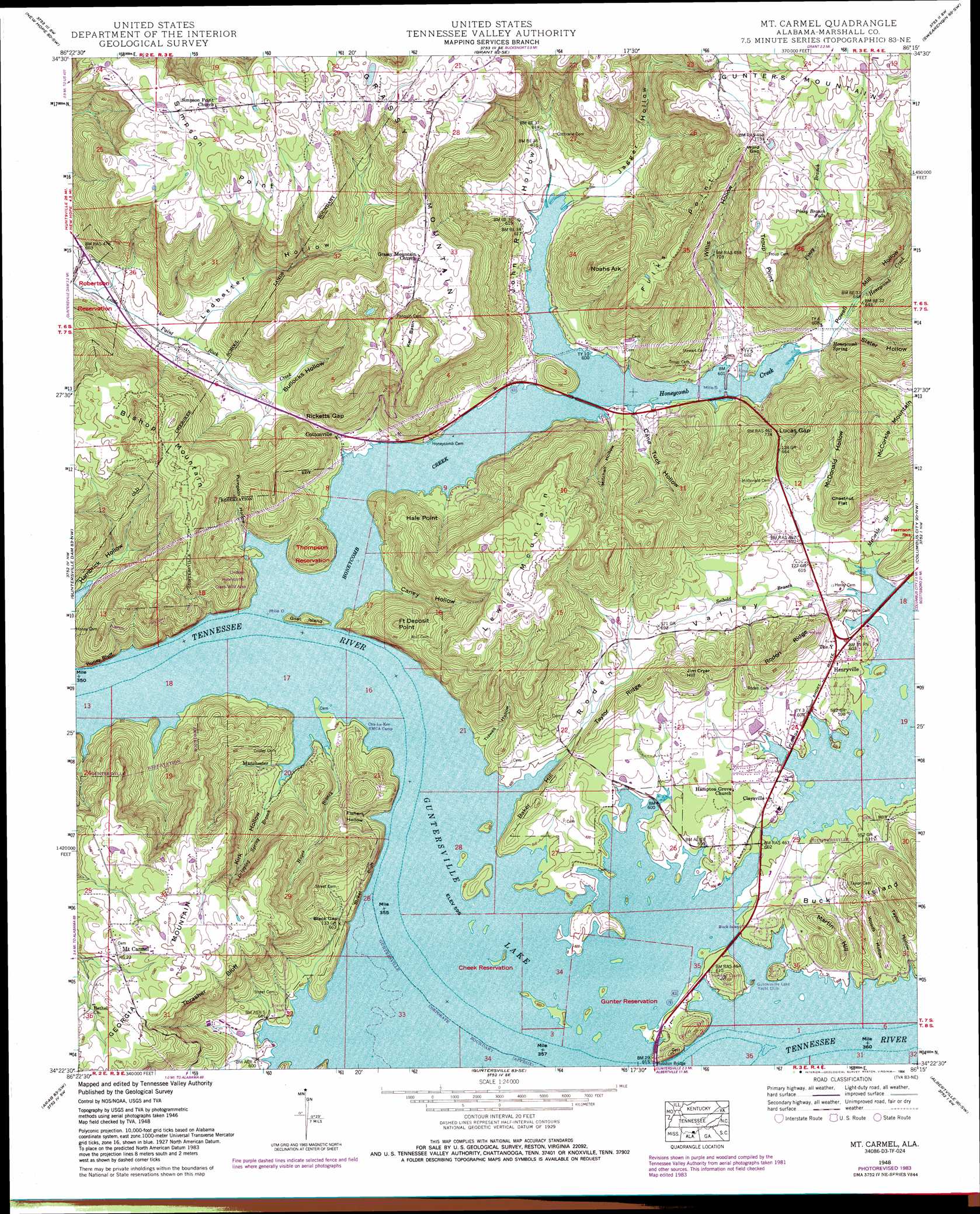
USGS Topo Quad 34086d3 - 1:24,000 scale
| Topo Map Name: | Mount Carmel |
| USGS Topo Quad ID: | 34086d3 |
| Print Size: | ca. 21 1/4" wide x 27" high |
| Southeast Coordinates: | 34.375° N latitude / 86.25° W longitude |
| Map Center Coordinates: | 34.4375° N latitude / 86.3125° W longitude |
| U.S. State: | AL |
| Filename: | o34086d3.jpg |
| Download Map JPG Image: | Mount Carmel topo map 1:24,000 scale |
| Map Type: | Topographic |
| Topo Series: | 7.5´ |
| Map Scale: | 1:24,000 |
| Source of Map Images: | United States Geological Survey (USGS) |
| Alternate Map Versions: |
Mt Carmel AL 1936 Download PDF Buy paper map Mt Carmel AL 1948, updated 1971 Download PDF Buy paper map Mt Carmel AL 1948, updated 1979 Download PDF Buy paper map Mt Carmel AL 1948, updated 1984 Download PDF Buy paper map Mt Carmel AL 1950, updated 1950 Download PDF Buy paper map Mt Carmel AL 1984, updated 1984 Download PDF Buy paper map Mount Carmel AL 2011 Download PDF Buy paper map Mount Carmel AL 2014 Download PDF Buy paper map |
1:24,000 Topo Quads surrounding Mount Carmel
Huntsville |
Moontown |
Paint Rock |
Lim Rock |
Scottsboro |
Farley |
New Hope |
Grant |
Swearengin |
Langston |
Newsome Sinks |
Guntersville Dam |
Mount Carmel |
Columbus City |
Grove Oak |
Hulaco |
Arab |
Guntersville |
Albertville |
Painter |
Holly Pond |
Brooksville |
Douglas |
Boaz |
Rodentown |
> Back to 34086a1 at 1:100,000 scale
> Back to 34086a1 at 1:250,000 scale
> Back to U.S. Topo Maps home
Mount Carmel topo map: Gazetteer
Mount Carmel: Airports
Guntersville Municipal Airport elevation 185m 606′Mount Carmel: Arches
Honeycomb Natural Bridge elevation 224m 734′Mount Carmel: Bars
Beards Bar elevation 181m 593′Beards Reef elevation 181m 593′
Browns Bar elevation 181m 593′
Mount Carmel: Basins
Key Basin elevation 292m 958′Mount Carmel: Capes
Fulks Point elevation 346m 1135′Hale Point elevation 276m 905′
Simpson Point elevation 368m 1207′
Troup Point elevation 339m 1112′
Mount Carmel: Cliffs
Honey Bluff elevation 203m 666′Street Bluff elevation 191m 626′
Thrasher Bluff elevation 303m 994′
Mount Carmel: Crossings
Fort Deposit Ferry (historical) elevation 181m 593′Mount Carmel: Falls
Piney Branch Falls elevation 320m 1049′Mount Carmel: Flats
Chestnut Flat elevation 269m 882′Mount Carmel: Gaps
Black Gap elevation 193m 633′Lucas Gap elevation 223m 731′
Ricketts Gap elevation 207m 679′
Word Gap elevation 351m 1151′
Mount Carmel: Islands
Buck Island elevation 257m 843′Goat Island elevation 201m 659′
McKee Island (historical) elevation 181m 593′
Mount Carmel: Parks
Lindsey-Honeycomb Creek Wild Area elevation 209m 685′Marshall County Park elevation 206m 675′
Yogi Bears Jellystone Park elevation 181m 593′
Mount Carmel: Populated Places
Buck Island Shores elevation 190m 623′Buck Island Subdivision elevation 203m 666′
Claysville elevation 190m 623′
Cottonville elevation 190m 623′
Cushion elevation 209m 685′
Fort Deposit (historical) elevation 181m 593′
Half Acre Estates elevation 195m 639′
Hayes Branch Subdivision elevation 185m 606′
Henryville elevation 189m 620′
Holiday Shores elevation 190m 623′
Honeycomb Park elevation 194m 636′
Johnson (historical) elevation 194m 636′
Manchester elevation 205m 672′
Mount Carmel elevation 321m 1053′
North (historical) elevation 190m 623′
Pine Shores elevation 185m 606′
Pinedale Shores elevation 184m 603′
Playground Shores elevation 181m 593′
Shady Acres elevation 184m 603′
Mount Carmel: Ridges
Roden Ridge elevation 255m 836′Taylor Ridge elevation 240m 787′
Mount Carmel: Springs
Cushion Spring elevation 185m 606′Honeycomb Spring elevation 183m 600′
Mount Carmel: Streams
Dripping Spring Branch elevation 182m 597′Hayes Branch elevation 185m 606′
Honeycomb Creek elevation 181m 593′
Jagger Branch elevation 181m 593′
Jagger Branch elevation 181m 593′
McCorkle Branch elevation 182m 597′
Piney Branch elevation 185m 606′
Seibold Branch elevation 182m 597′
Mount Carmel: Summits
Baker Hill elevation 216m 708′Bishop Mountain elevation 345m 1131′
Fort Deposit Point elevation 312m 1023′
Grassy Mountain elevation 372m 1220′
Jim Cryar Hill elevation 276m 905′
Lewis Mountain elevation 354m 1161′
Martin Hill elevation 232m 761′
Noahs Ark elevation 327m 1072′
Mount Carmel: Valleys
Bullocks Hollow elevation 186m 610′Cane Tuck Hollow elevation 182m 597′
Caney Hollow elevation 181m 593′
Fishers Hollow elevation 181m 593′
Fishing Hollow elevation 181m 593′
Jagger Hollow elevation 183m 600′
John R Hollow elevation 181m 593′
Kirk Hollow elevation 181m 593′
Ledbetter Hollow elevation 183m 600′
McDonald Hollow elevation 189m 620′
Mitchell Hollow elevation 186m 610′
Powell Mill Hollow elevation 181m 593′
Pumpkin Hollow elevation 181m 593′
Roden Valley elevation 181m 593′
Slater Hollow elevation 189m 620′
Taylor Hollow elevation 182m 597′
Tidwell Hollow elevation 183m 600′
Willis Hollow elevation 188m 616′
Woods Hollow elevation 184m 603′
Mount Carmel digital topo map on disk
Buy this Mount Carmel topo map showing relief, roads, GPS coordinates and other geographical features, as a high-resolution digital map file on DVD: