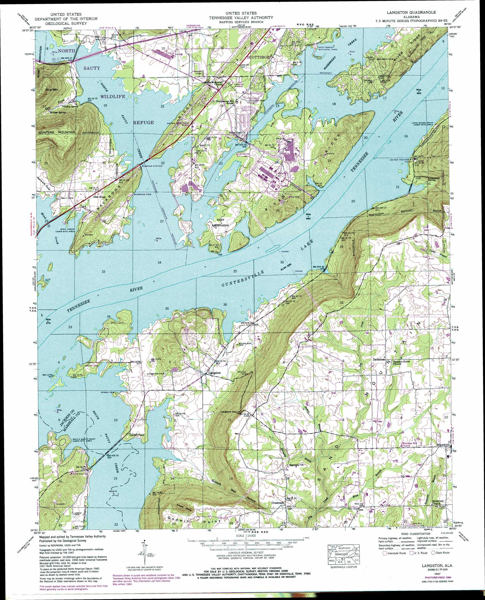
Langston Topo Map Alabama
To zoom in, hover over the map of Langston
USGS Topo Quad 34086e1 - 1:24,000 scale
| Topo Map Name: | Langston |
| USGS Topo Quad ID: | 34086e1 |
| Print Size: | ca. 21 1/4" wide x 27" high |
| Southeast Coordinates: | 34.5° N latitude / 86° W longitude |
| Map Center Coordinates: | 34.5625° N latitude / 86.0625° W longitude |
| U.S. State: | AL |
| Filename: | o34086e1.jpg |
| Download Map JPG Image: | Langston topo map 1:24,000 scale |
| Map Type: | Topographic |
| Topo Series: | 7.5´ |
| Map Scale: | 1:24,000 |
| Source of Map Images: | United States Geological Survey (USGS) |
| Alternate Map Versions: |
Langston AL 1936 Download PDF Buy paper map Langston AL 1947, updated 1972 Download PDF Buy paper map Langston AL 1947, updated 1985 Download PDF Buy paper map Langston AL 1950 Download PDF Buy paper map Langston AL 2011 Download PDF Buy paper map Langston AL 2014 Download PDF Buy paper map |
1:24,000 Topo Quads surrounding Langston
Hollytree |
Princeton |
Mud Creek |
Wannville |
Stevenson |
Paint Rock |
Lim Rock |
Scottsboro |
Hollywood |
Henagar |
Grant |
Swearengin |
Langston |
Dutton |
Sylvania |
Mount Carmel |
Columbus City |
Grove Oak |
Fyffe |
Chavies |
Guntersville |
Albertville |
Painter |
Crossville |
Portersville |
> Back to 34086e1 at 1:100,000 scale
> Back to 34086a1 at 1:250,000 scale
> Back to U.S. Topo Maps home
Langston topo map: Gazetteer
Langston: Bars
Caldwell Bar elevation 181m 593′Gross Bar elevation 181m 593′
Mink Creek Bar elevation 181m 593′
North Sauty Creek Bar elevation 181m 593′
Langston: Basins
Fricks Cove elevation 325m 1066′Langston: Crossings
Caldwell Ferry (historical) elevation 181m 593′Larkin Ferry (historical) elevation 181m 593′
Section Ferry (historical) elevation 181m 593′
Langston: Gaps
Langston Gap elevation 357m 1171′Langston: Islands
Goose Pond Island elevation 194m 636′Larkins Towhead (historical) elevation 181m 593′
Langston: Lakes
Wiley Lake (historical) elevation 181m 593′Langston: Parks
Goose Pond Colony Park elevation 188m 616′Langston City Park elevation 185m 606′
North Sauty Wildlife Refuge elevation 181m 593′
Scottsboro Municipal Park elevation 183m 600′
Langston: Populated Places
Bradford Subdivision elevation 183m 600′Carver Subdivision elevation 201m 659′
Chisenhall Subdivision elevation 186m 610′
Crossroad elevation 362m 1187′
Davistown elevation 380m 1246′
Dodsonville (historical) elevation 181m 593′
Jackson Subdivision elevation 185m 606′
Lake Shore Drive Subdivision elevation 188m 616′
Lakeview Shores elevation 195m 639′
Langston elevation 191m 626′
Lewis Evans Subdivision elevation 189m 620′
Macedonia elevation 384m 1259′
New Hope elevation 189m 620′
Sauta (historical) elevation 181m 593′
Skyline Shores elevation 187m 613′
South Sauty Subdivision elevation 184m 603′
Langston: Post Offices
Sauta Post Office (historical) elevation 181m 593′Langston: Ridges
Backbone Ridge elevation 217m 711′Langston: Springs
Bridges Spring elevation 196m 643′Chisenhall Spring elevation 184m 603′
Guffey Spring elevation 192m 629′
Yeager Spring elevation 188m 616′
Langston: Streams
Harmony Branch elevation 338m 1108′Mink Branch elevation 323m 1059′
Mink Creek elevation 181m 593′
North Sauty Creek elevation 181m 593′
Roseberry Creek elevation 181m 593′
Skelton Branch elevation 349m 1145′
South Sauty Creek elevation 181m 593′
Langston: Summits
Pine Mountain elevation 379m 1243′Langston: Swamps
Tupelo Swamp (historical) elevation 181m 593′Langston: Valleys
Ashmore Cove elevation 184m 603′Dry Cove elevation 182m 597′
Sublett Gap Hollow elevation 183m 600′
Langston digital topo map on disk
Buy this Langston topo map showing relief, roads, GPS coordinates and other geographical features, as a high-resolution digital map file on DVD: