Farley Topo Map Alabama
To zoom in, hover over the map of Farley
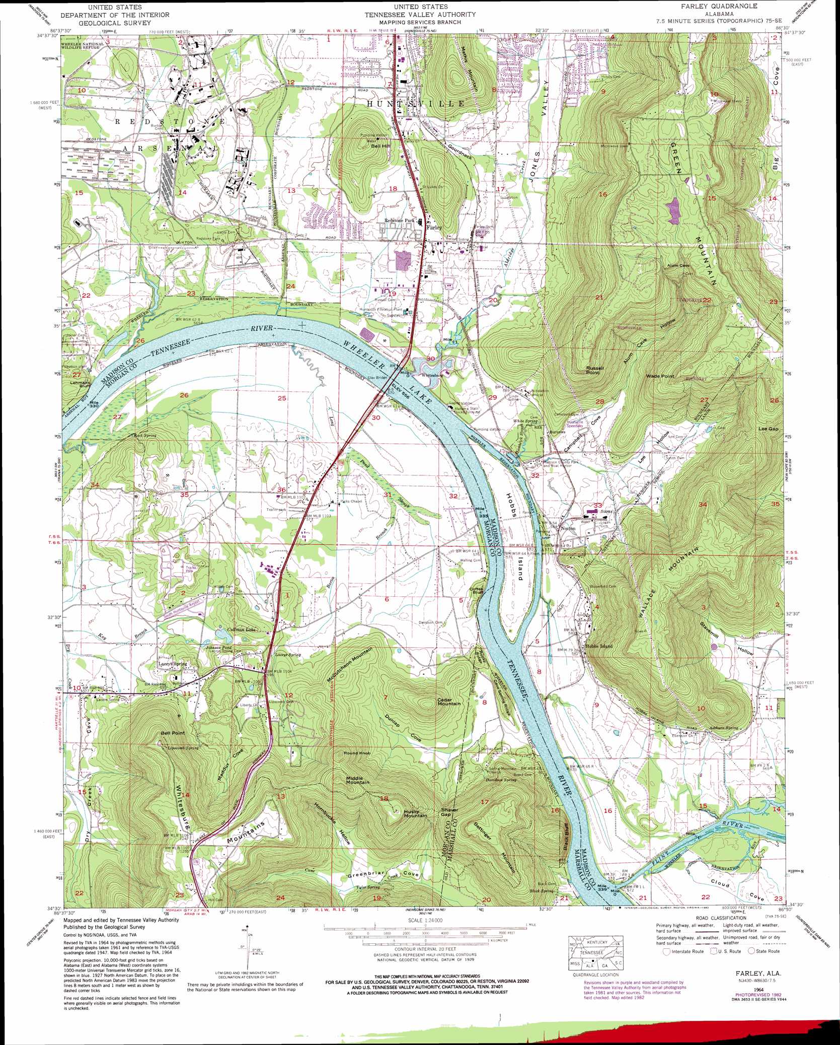
USGS Topo Quad 34086e5 - 1:24,000 scale
| Topo Map Name: | Farley |
| USGS Topo Quad ID: | 34086e5 |
| Print Size: | ca. 21 1/4" wide x 27" high |
| Southeast Coordinates: | 34.5° N latitude / 86.5° W longitude |
| Map Center Coordinates: | 34.5625° N latitude / 86.5625° W longitude |
| U.S. State: | AL |
| Filename: | o34086e5.jpg |
| Download Map JPG Image: | Farley topo map 1:24,000 scale |
| Map Type: | Topographic |
| Topo Series: | 7.5´ |
| Map Scale: | 1:24,000 |
| Source of Map Images: | United States Geological Survey (USGS) |
| Alternate Map Versions: |
Farley AL 1936 Download PDF Buy paper map Farley AL 1947, updated 1956 Download PDF Buy paper map Farley AL 1950 Download PDF Buy paper map Farley AL 1964, updated 1966 Download PDF Buy paper map Farley AL 1964, updated 1982 Download PDF Buy paper map Farley AL 1964, updated 1982 Download PDF Buy paper map Farley AL 2011 Download PDF Buy paper map Farley AL 2014 Download PDF Buy paper map |
1:24,000 Topo Quads surrounding Farley
Capshaw |
Jeff |
Meridianville |
Maysville |
Hollytree |
Greenbrier |
Madison |
Huntsville |
Moontown |
Paint Rock |
Mason Ridge |
Triana |
Farley |
New Hope |
Grant |
Somerville |
Center Grove |
Newsome Sinks |
Guntersville Dam |
Mount Carmel |
Eva |
Lawrence Cove |
Hulaco |
Arab |
Guntersville |
> Back to 34086e1 at 1:100,000 scale
> Back to 34086a1 at 1:250,000 scale
> Back to U.S. Topo Maps home
Farley topo map: Gazetteer
Farley: Airports
South Huntsville Airport elevation 185m 606′Farley: Bars
Burndine Bar (historical) elevation 183m 600′Chunns Bar (historical) elevation 170m 557′
Whitesburg Bar (historical) elevation 200m 656′
Farley: Bridges
Clay Bridge (historical) elevation 170m 557′Farley: Cliffs
Black Bluff elevation 170m 557′Coffee Bluff elevation 170m 557′
Lehmans Bluff elevation 179m 587′
Farley: Crossings
Leman Ferry (historical) elevation 170m 557′McMahans Ferry (historical) elevation 170m 557′
Whitesburg Ferry (historical) elevation 170m 557′
Farley: Gaps
Lee Gap elevation 321m 1053′Shaver Gap elevation 251m 823′
Farley: Guts
Pond Slough elevation 171m 561′Farley: Harbors
Madison County Park and Boat Harbor elevation 175m 574′Farley: Islands
Hobbs Island elevation 173m 567′Farley: Lakes
Johnson Pond elevation 187m 613′Lipscomb Pond elevation 191m 626′
Farley: Parks
Laceys Spring Recreation Center elevation 180m 590′Madison County Nature Study Center elevation 406m 1332′
Farley: Populated Places
Burrows elevation 179m 587′Chimney Springs elevation 199m 652′
Farley elevation 184m 603′
Fox Run elevation 194m 636′
Green Cove Meadows elevation 180m 590′
Hobbs Island elevation 182m 597′
Incline elevation 173m 567′
Laceys Spring elevation 216m 708′
Mountain Gap Estates elevation 181m 593′
Norton elevation 178m 583′
Redstone Park elevation 178m 583′
Regent Forest elevation 197m 646′
Sandhurst Park elevation 177m 580′
South Park Estates elevation 177m 580′
Whitesburg elevation 170m 557′
Woodridge elevation 184m 603′
Farley: Post Offices
Laceys Springs Post Office elevation 221m 725′Farley: Ridges
Cave Spring Ridge elevation 196m 643′Rocky Ridge elevation 202m 662′
Farley: Springs
Ashburn Spring elevation 184m 603′Black Spring elevation 173m 567′
Davidson Spring elevation 196m 643′
Laceys Spring elevation 189m 620′
Lipscomb Spring elevation 213m 698′
Old Rasson Spring elevation 213m 698′
Rock Spring elevation 175m 574′
Tyler Spring elevation 199m 652′
White Spring elevation 174m 570′
Farley: Streams
Aldridge Creek elevation 170m 557′Bartee Branch elevation 170m 557′
Flint River elevation 170m 557′
Gooch Creek elevation 231m 757′
Hambrick Slough elevation 170m 557′
Farley: Summits
Bell Hill elevation 284m 931′Bell Point elevation 387m 1269′
Bettinger Mountain elevation 379m 1243′
Cedar Mountain elevation 288m 944′
Husky Mountain elevation 378m 1240′
Mathis Mountain elevation 313m 1026′
McCutcheon Mountain elevation 244m 800′
Middle Mountain elevation 377m 1236′
Round Knob elevation 353m 1158′
Russell Point elevation 397m 1302′
Wade Point elevation 401m 1315′
Wallace Mountain elevation 409m 1341′
Whitesburg Mountain elevation 391m 1282′
Farley: Valleys
Alum Cave Hollow elevation 198m 649′Black Hollow elevation 189m 620′
Campbell Cove elevation 177m 580′
Cloud Cove elevation 174m 570′
Dunlap Cove elevation 177m 580′
Gourdneck Valley elevation 177m 580′
Hornbuckle Hollow elevation 189m 620′
Jones Valley elevation 170m 557′
Lee Hollow elevation 180m 590′
Maddux Cove elevation 221m 725′
Stavemill Hollow elevation 173m 567′
Farley digital topo map on disk
Buy this Farley topo map showing relief, roads, GPS coordinates and other geographical features, as a high-resolution digital map file on DVD: