Triana Topo Map Alabama
To zoom in, hover over the map of Triana
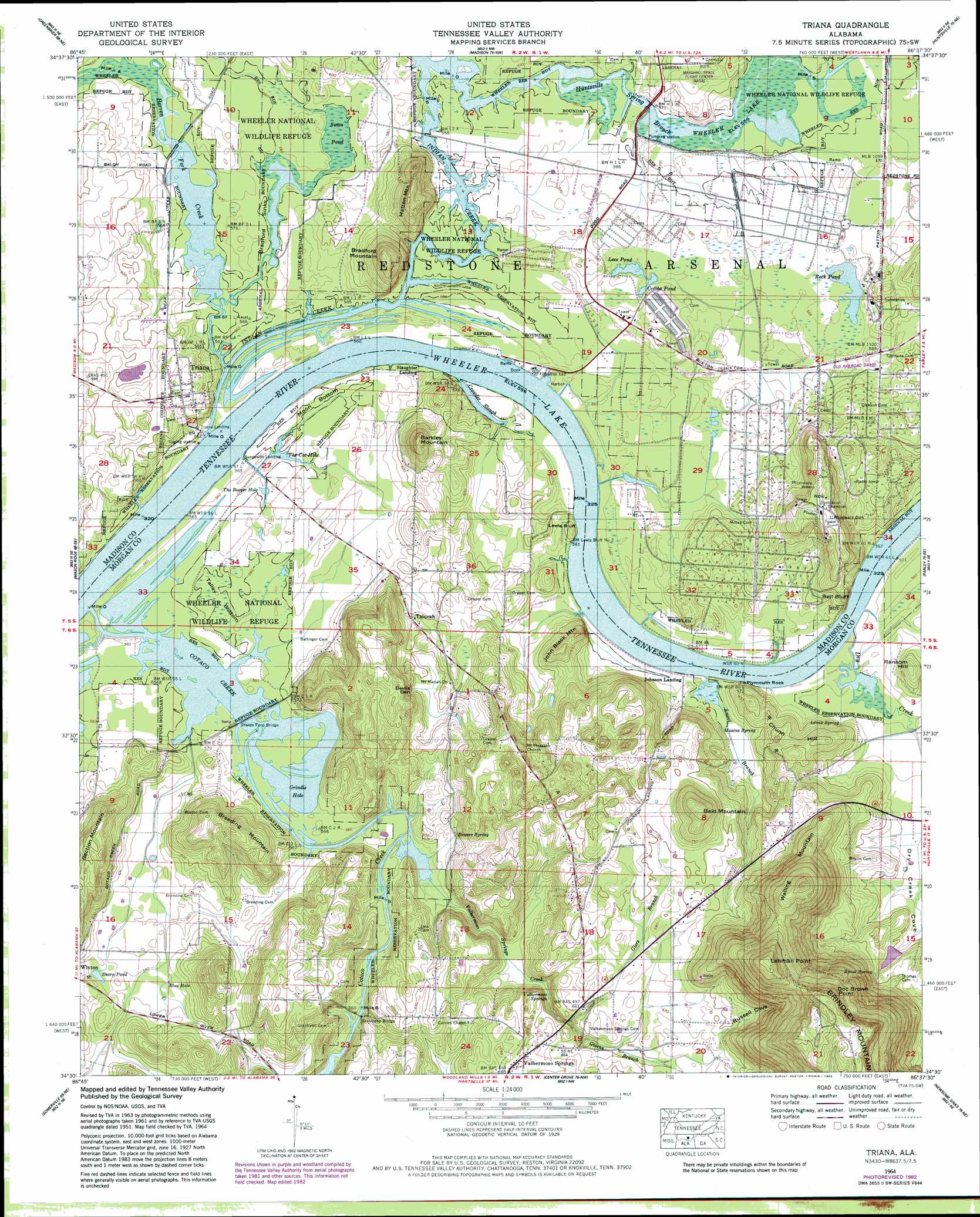
USGS Topo Quad 34086e6 - 1:24,000 scale
| Topo Map Name: | Triana |
| USGS Topo Quad ID: | 34086e6 |
| Print Size: | ca. 21 1/4" wide x 27" high |
| Southeast Coordinates: | 34.5° N latitude / 86.625° W longitude |
| Map Center Coordinates: | 34.5625° N latitude / 86.6875° W longitude |
| U.S. State: | AL |
| Filename: | o34086e6.jpg |
| Download Map JPG Image: | Triana topo map 1:24,000 scale |
| Map Type: | Topographic |
| Topo Series: | 7.5´ |
| Map Scale: | 1:24,000 |
| Source of Map Images: | United States Geological Survey (USGS) |
| Alternate Map Versions: |
Triana AL 1936 Download PDF Buy paper map Triana AL 1948, updated 1963 Download PDF Buy paper map Triana AL 1951 Download PDF Buy paper map Triana AL 1964, updated 1965 Download PDF Buy paper map Triana AL 1964, updated 1983 Download PDF Buy paper map Triana AL 2011 Download PDF Buy paper map Triana AL 2014 Download PDF Buy paper map |
1:24,000 Topo Quads surrounding Triana
Athens |
Capshaw |
Jeff |
Meridianville |
Maysville |
Tanner |
Greenbrier |
Madison |
Huntsville |
Moontown |
Decatur |
Mason Ridge |
Triana |
Farley |
New Hope |
Hartselle |
Somerville |
Center Grove |
Newsome Sinks |
Guntersville Dam |
Falkville |
Eva |
Lawrence Cove |
Hulaco |
Arab |
> Back to 34086e1 at 1:100,000 scale
> Back to 34086a1 at 1:250,000 scale
> Back to U.S. Topo Maps home
Triana topo map: Gazetteer
Triana: Bars
Indian Creek Bar elevation 170m 557′Lees Bar (historical) elevation 170m 557′
Triana Bar (historical) elevation 170m 557′
Triana: Basins
Devils Den elevation 179m 587′Triana: Bays
Grindle Hole elevation 170m 557′Triana: Bends
Moon Bottom elevation 171m 561′Triana: Bridges
Grantland Bridge elevation 170m 557′Sharps Ford Bridge elevation 170m 557′
Triana: Capes
Doc Brown Point elevation 354m 1161′Triana: Cliffs
Bell Bluff elevation 172m 564′Lewis Buff elevation 170m 557′
Plymouth Rock elevation 171m 561′
Triana: Crossings
Cotaco Ferry (historical) elevation 170m 557′Draper Ferry (historical) elevation 170m 557′
Lewis Ferry (historical) elevation 170m 557′
Sharp Ford elevation 170m 557′
Slaughter Ferry (historical) elevation 170m 557′
Sunnyside Ferry (historical) elevation 170m 557′
Talucah Ferry (historical) elevation 170m 557′
Triana: Lakes
Blue Hole elevation 175m 574′Cribbs Pond elevation 171m 561′
Lees Pond elevation 170m 557′
Rock Pond elevation 171m 561′
Sharp Pond elevation 177m 580′
Swan Pond elevation 170m 557′
The Booger Hole elevation 170m 557′
The Cat Hole elevation 170m 557′
Triana: Parks
Flamingo Park elevation 189m 620′Redstone Arsenal Recreation Area elevation 171m 561′
Triana Recreation Area elevation 170m 557′
Triana: Populated Places
Talucah elevation 183m 600′Triana elevation 190m 623′
Valhermoso Springs elevation 201m 659′
Triana: Post Offices
Valhermoso Springs Post Office elevation 201m 659′Triana: Ridges
Breeding Mountain elevation 230m 754′Chunn Hill elevation 202m 662′
Triana: Springs
Bowers Spring elevation 173m 567′Cooter Terrell Spring elevation 207m 679′
Cove Spring elevation 170m 557′
Grantland Spring elevation 176m 577′
Lenox Spring elevation 173m 567′
Mascus Spring elevation 171m 561′
Spout Spring elevation 195m 639′
Valhermoso Springs elevation 174m 570′
Walden Spring elevation 200m 656′
Triana: Streams
Barren Fork Creek elevation 170m 557′Cotaco Creek elevation 169m 554′
Crowder Slough elevation 170m 557′
Dry Creek elevation 170m 557′
Giers Branch elevation 182m 597′
Givens Branch elevation 182m 597′
Huntsville Spring Branch elevation 169m 554′
Indian Creek elevation 170m 557′
Kay Branch elevation 171m 561′
Smoot Branch elevation 170m 557′
Valhermoso Springs Creek elevation 170m 557′
Triana: Summits
Bald Mountain elevation 272m 892′Barkley Mountain elevation 245m 803′
Bradford Mountain elevation 207m 679′
Hatton Mountain elevation 249m 816′
Hatton Mountain elevation 242m 793′
John Black Mountain elevation 214m 702′
Lehman Point elevation 385m 1263′
Ransom Hill elevation 196m 643′
Section Mountain elevation 232m 761′
Walling Mountain elevation 352m 1154′
Triana: Swamps
Talley Bottom elevation 171m 561′Triana: Valleys
Dry Creek Cove elevation 172m 564′Russell Cove elevation 203m 666′
Triana digital topo map on disk
Buy this Triana topo map showing relief, roads, GPS coordinates and other geographical features, as a high-resolution digital map file on DVD: