Mud Creek Topo Map Alabama
To zoom in, hover over the map of Mud Creek
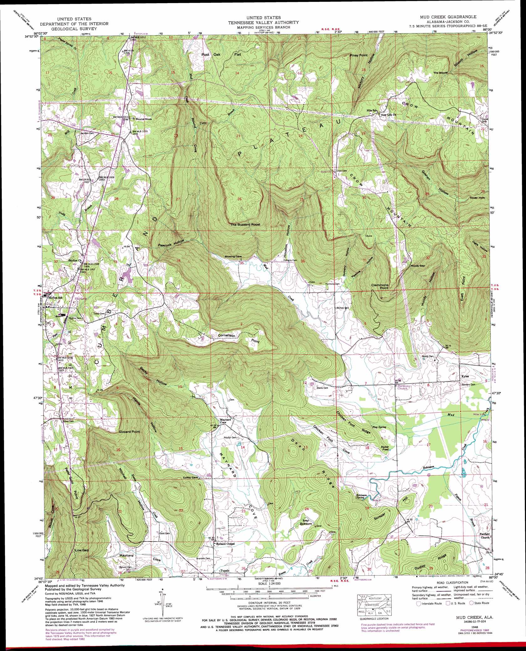
USGS Topo Quad 34086g1 - 1:24,000 scale
| Topo Map Name: | Mud Creek |
| USGS Topo Quad ID: | 34086g1 |
| Print Size: | ca. 21 1/4" wide x 27" high |
| Southeast Coordinates: | 34.75° N latitude / 86° W longitude |
| Map Center Coordinates: | 34.8125° N latitude / 86.0625° W longitude |
| U.S. State: | AL |
| Filename: | o34086g1.jpg |
| Download Map JPG Image: | Mud Creek topo map 1:24,000 scale |
| Map Type: | Topographic |
| Topo Series: | 7.5´ |
| Map Scale: | 1:24,000 |
| Source of Map Images: | United States Geological Survey (USGS) |
| Alternate Map Versions: |
Mud Creek AL 1936 Download PDF Buy paper map Mud Creek AL 1948, updated 1975 Download PDF Buy paper map Mud Creek AL 1948, updated 1977 Download PDF Buy paper map Mud Creek AL 1948, updated 1982 Download PDF Buy paper map Mud Creek AL 1948, updated 1986 Download PDF Buy paper map Mud Creek AL 1948, updated 1987 Download PDF Buy paper map Mud Creek AL 1951, updated 1951 Download PDF Buy paper map Mud Creek AL 2011 Download PDF Buy paper map Mud Creek AL 2014 Download PDF Buy paper map |
1:24,000 Topo Quads surrounding Mud Creek
Huntland |
Beans Creek |
Pitcher Ridge |
Sinking Cove |
Orme |
King Cove |
Estill Fork |
Hytop |
Eureka |
Doran Cove |
Hollytree |
Princeton |
Mud Creek |
Wannville |
Stevenson |
Paint Rock |
Lim Rock |
Scottsboro |
Hollywood |
Henagar |
Grant |
Swearengin |
Langston |
Dutton |
Sylvania |
> Back to 34086e1 at 1:100,000 scale
> Back to 34086a1 at 1:250,000 scale
> Back to U.S. Topo Maps home
Mud Creek topo map: Gazetteer
Mud Creek: Basins
Ivey Bottom elevation 193m 633′Never Hole elevation 301m 987′
Mud Creek: Capes
Clemmons Point elevation 469m 1538′Cornelison Point elevation 475m 1558′
Evett Point elevation 462m 1515′
Gizzard Point elevation 465m 1525′
Peter Gold Point elevation 469m 1538′
Mud Creek: Cliffs
Piney Point elevation 474m 1555′The Slipoff elevation 444m 1456′
Mud Creek: Dams
Hill Pond Dam elevation 491m 1610′Mud Creek: Gaps
Low Gap elevation 343m 1125′Moody Gap elevation 478m 1568′
Mud Creek: Lakes
Bucker Pond elevation 188m 616′Mud Creek: Populated Places
Cumberland Mountain Farm Colony (historical) elevation 483m 1584′Kyles elevation 191m 626′
Maynard Cove elevation 210m 688′
Mud Creek (historical) elevation 205m 672′
Skyline elevation 485m 1591′
Tupelo elevation 198m 649′
Mud Creek: Reservoirs
Hill Pond elevation 491m 1610′Mud Creek: Ridges
Chicken Foot Ridge elevation 225m 738′Dean Ridge elevation 225m 738′
Dudley Ridge elevation 224m 734′
Mud Creek: Springs
Flag Spring elevation 187m 613′Robinson Spring elevation 189m 620′
Mud Creek: Streams
Bill Creek elevation 205m 672′Evans Creek elevation 194m 636′
Pegues Branch elevation 187m 613′
Poplar Spring Creek elevation 473m 1551′
Robinson Creek elevation 185m 606′
Tubbs Branch elevation 338m 1108′
Mud Creek: Summits
Crow Mountain elevation 519m 1702′Round Knob elevation 525m 1722′
Scraper Hill elevation 239m 784′
The Buzzard Roost elevation 479m 1571′
Mud Creek: Valleys
Becky Hollow elevation 220m 721′Chicken Foot Cove elevation 189m 620′
Dolberry Hollow elevation 214m 702′
Harris Hollow elevation 200m 656′
Houston Hollow elevation 195m 639′
Mitchell Hollow elevation 201m 659′
Moody Hollow elevation 191m 626′
Peacock Hollow elevation 202m 662′
Pipeline Hollow elevation 212m 695′
Round Cove elevation 206m 675′
Mud Creek digital topo map on disk
Buy this Mud Creek topo map showing relief, roads, GPS coordinates and other geographical features, as a high-resolution digital map file on DVD: