Poplar Springs Topo Map Alabama
To zoom in, hover over the map of Poplar Springs
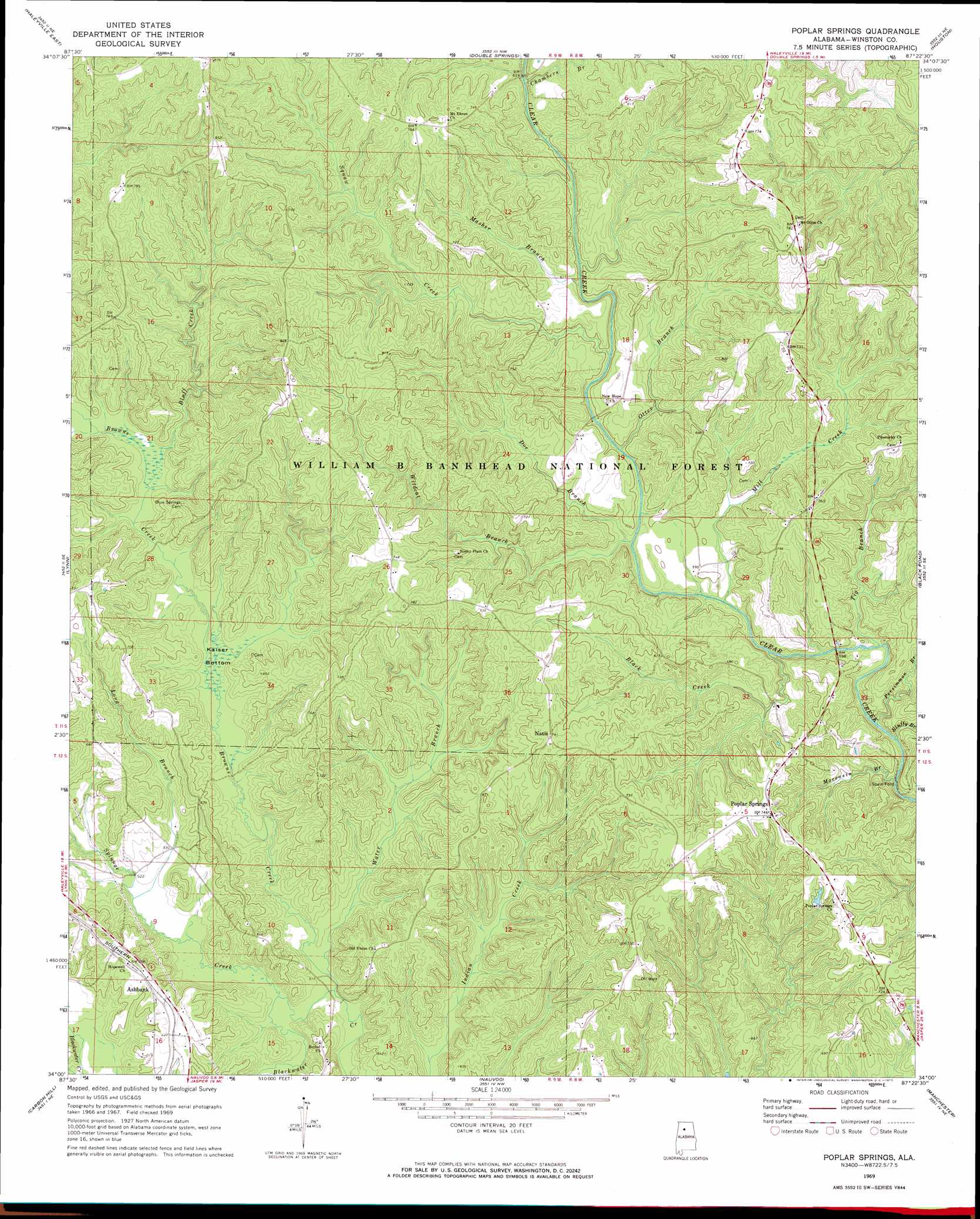
USGS Topo Quad 34087a4 - 1:24,000 scale
| Topo Map Name: | Poplar Springs |
| USGS Topo Quad ID: | 34087a4 |
| Print Size: | ca. 21 1/4" wide x 27" high |
| Southeast Coordinates: | 34° N latitude / 87.375° W longitude |
| Map Center Coordinates: | 34.0625° N latitude / 87.4375° W longitude |
| U.S. State: | AL |
| Filename: | o34087a4.jpg |
| Download Map JPG Image: | Poplar Springs topo map 1:24,000 scale |
| Map Type: | Topographic |
| Topo Series: | 7.5´ |
| Map Scale: | 1:24,000 |
| Source of Map Images: | United States Geological Survey (USGS) |
| Alternate Map Versions: |
Poplar Springs AL 1969, updated 1973 Download PDF Buy paper map Poplar Springs AL 1969, updated 1973 Download PDF Buy paper map Poplar Springs AL 2000, updated 2003 Download PDF Buy paper map Poplar Springs AL 2011 Download PDF Buy paper map Poplar Springs AL 2014 Download PDF Buy paper map |
| FStopo: | US Forest Service topo Poplar Springs is available: Download FStopo PDF Download FStopo TIF |
1:24,000 Topo Quads surrounding Poplar Springs
Phil Campbell |
Kinlock Spring |
Bee Branch |
Grayson |
Upshaw |
Haleyville West |
Haleyville East |
Double Springs |
Houston |
Addison |
Gold Mine |
Lynn |
Poplar Springs |
Black Pond |
Arley |
Glen Allen |
Carbon Hill |
Nauvoo |
Manchester |
Sunlight |
Hubbertville |
Howard |
Townley |
Jasper |
Cordova |
> Back to 34087a1 at 1:100,000 scale
> Back to 34086a1 at 1:250,000 scale
> Back to U.S. Topo Maps home
Poplar Springs topo map: Gazetteer
Poplar Springs: Crossings
Spain Ford elevation 171m 561′Poplar Springs: Oilfields
Nauvoo Gas Field elevation 191m 626′Poplar Springs: Populated Places
Ashbank elevation 194m 636′Natis elevation 226m 741′
Poplar Springs elevation 226m 741′
Poplar Springs: Post Offices
Ballenger Post Office (historical) elevation 229m 751′Browns Creek Post Office (historical) elevation 233m 764′
Natis Post Office (historical) elevation 226m 741′
Poplar Springs: Streams
Black Creek elevation 169m 554′Bluff Creek elevation 170m 557′
Bluffy Branch elevation 167m 547′
Browns Creek elevation 156m 511′
Chambers Branch elevation 195m 639′
Doe Branch elevation 171m 561′
Long Branch elevation 156m 511′
Masher Branch elevation 190m 623′
Mill Creek elevation 170m 557′
Moccasin Branch elevation 163m 534′
Otter Branch elevation 178m 583′
Persimmon Branch elevation 170m 557′
Splunge Creek elevation 156m 511′
Squaw Creek elevation 186m 610′
Tig Branch elevation 168m 551′
Water Branch elevation 156m 511′
Wildcat Branch elevation 175m 574′
Poplar Springs: Swamps
Kaiser Bottom elevation 162m 531′Poplar Springs digital topo map on disk
Buy this Poplar Springs topo map showing relief, roads, GPS coordinates and other geographical features, as a high-resolution digital map file on DVD: