Brilliant Topo Map Alabama
To zoom in, hover over the map of Brilliant
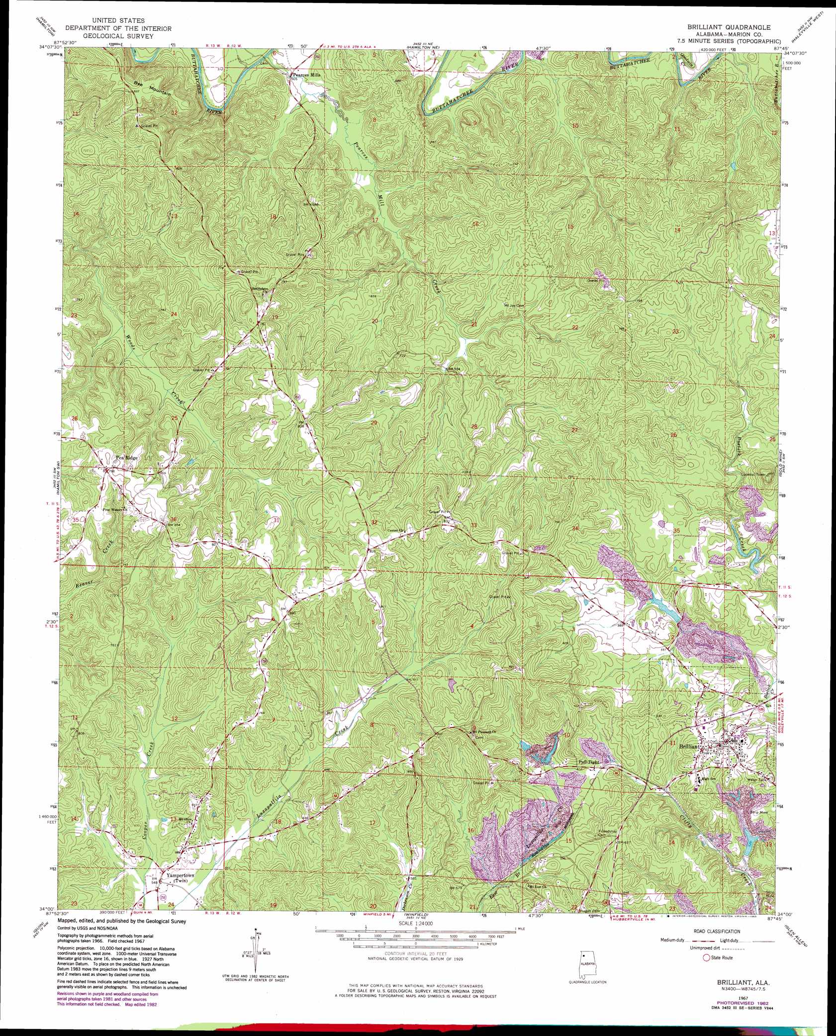
USGS Topo Quad 34087a7 - 1:24,000 scale
| Topo Map Name: | Brilliant |
| USGS Topo Quad ID: | 34087a7 |
| Print Size: | ca. 21 1/4" wide x 27" high |
| Southeast Coordinates: | 34° N latitude / 87.75° W longitude |
| Map Center Coordinates: | 34.0625° N latitude / 87.8125° W longitude |
| U.S. State: | AL |
| Filename: | o34087a7.jpg |
| Download Map JPG Image: | Brilliant topo map 1:24,000 scale |
| Map Type: | Topographic |
| Topo Series: | 7.5´ |
| Map Scale: | 1:24,000 |
| Source of Map Images: | United States Geological Survey (USGS) |
| Alternate Map Versions: |
Brilliant AL 1967, updated 1968 Download PDF Buy paper map Brilliant AL 1967, updated 1979 Download PDF Buy paper map Brilliant AL 1967, updated 1983 Download PDF Buy paper map Brilliant AL 2011 Download PDF Buy paper map Brilliant AL 2014 Download PDF Buy paper map |
1:24,000 Topo Quads surrounding Brilliant
Vina |
Hodges |
Hackleburg |
Phil Campbell |
Kinlock Spring |
Weston |
Hamilton |
Hamilton Ne |
Haleyville West |
Haleyville East |
Henson Springs |
Hamilton Sw |
Brilliant |
Gold Mine |
Lynn |
Beaverton |
Guin |
Winfield |
Glen Allen |
Carbon Hill |
Vernon |
Bluff |
Winfield Se |
Hubbertville |
Howard |
> Back to 34087a1 at 1:100,000 scale
> Back to 34086a1 at 1:250,000 scale
> Back to U.S. Topo Maps home
Brilliant topo map: Gazetteer
Brilliant: Dams
Brilliant Lake Dam elevation 163m 534′Little New River Lake Number 1 Dam elevation 178m 583′
Little New River Lake Number 2 Dam elevation 175m 574′
Brilliant: Parks
Douglas Walker Stadium elevation 195m 639′Brilliant: Populated Places
Brilliant elevation 189m 620′Pea Ridge elevation 242m 793′
Pearces Mills elevation 158m 518′
Pull Tight elevation 185m 606′
Twin elevation 181m 593′
Twin elevation 166m 544′
Yampertown elevation 172m 564′
Brilliant: Reservoirs
Brilliant Lake elevation 163m 534′Little New River Lake Number 1 elevation 178m 583′
Little New River Lake Number 2 elevation 175m 574′
Brilliant: Ridges
Bee Mountain elevation 257m 843′Brilliant: Streams
Goodwin Creek elevation 167m 547′Pearces Mill Creek elevation 151m 495′
Brilliant digital topo map on disk
Buy this Brilliant topo map showing relief, roads, GPS coordinates and other geographical features, as a high-resolution digital map file on DVD: