Hodges Topo Map Alabama
To zoom in, hover over the map of Hodges
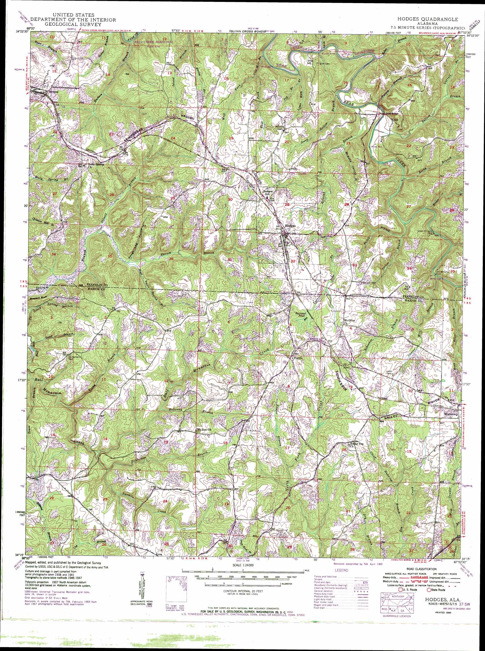
USGS Topo Quad 34087c8 - 1:24,000 scale
| Topo Map Name: | Hodges |
| USGS Topo Quad ID: | 34087c8 |
| Print Size: | ca. 21 1/4" wide x 27" high |
| Southeast Coordinates: | 34.25° N latitude / 87.875° W longitude |
| Map Center Coordinates: | 34.3125° N latitude / 87.9375° W longitude |
| U.S. State: | AL |
| Filename: | o34087c8.jpg |
| Download Map JPG Image: | Hodges topo map 1:24,000 scale |
| Map Type: | Topographic |
| Topo Series: | 7.5´ |
| Map Scale: | 1:24,000 |
| Source of Map Images: | United States Geological Survey (USGS) |
| Alternate Map Versions: |
Hodges AL 1936 Download PDF Buy paper map Hodges AL 1949, updated 1949 Download PDF Buy paper map Hodges AL 1949, updated 1949 Download PDF Buy paper map Hodges AL 1998, updated 2000 Download PDF Buy paper map Hodges AL 2011 Download PDF Buy paper map Hodges AL 2014 Download PDF Buy paper map |
1:24,000 Topo Quads surrounding Hodges
Belmont |
Pleasant Site |
Pleasant Grove |
Frankfort |
Russellville |
Red Bay |
Halltown |
Guinn Cross Roads |
Isbell |
Spruce Pine |
Shottsville |
Vina |
Hodges |
Hackleburg |
Phil Campbell |
Bexar |
Weston |
Hamilton |
Hamilton Ne |
Haleyville West |
Detroit |
Henson Springs |
Hamilton Sw |
Brilliant |
Gold Mine |
> Back to 34087a1 at 1:100,000 scale
> Back to 34086a1 at 1:250,000 scale
> Back to U.S. Topo Maps home
Hodges topo map: Gazetteer
Hodges: Arches
Rock Bridge elevation 217m 711′Hodges: Bridges
Scott Bridge elevation 177m 580′Hodges: Cliffs
Buzzard Bluff elevation 185m 606′Hodges: Crossings
Green Williams Ford elevation 180m 590′Jim Williams Ford elevation 186m 610′
Scott Ford elevation 176m 577′
Hodges: Dams
Hodges Dam elevation 256m 839′Hodges: Oilfields
Pilot Hill Gas Field elevation 212m 695′Hodges: Parks
Rock Bridge Canyon Park elevation 230m 754′Hodges: Populated Places
Atwood elevation 226m 741′Hodges elevation 258m 846′
Pigeye elevation 265m 869′
Wiginton elevation 269m 882′
Hodges: Post Offices
Hodges Post Office elevation 257m 843′Hodges: Reservoirs
Railroad Pond elevation 257m 843′Hodges: Streams
Bailey Branch elevation 187m 613′Bony Bluff Branch elevation 180m 590′
Bridge Branch elevation 183m 600′
Bullock Branch elevation 177m 580′
Clear Running Branch elevation 201m 659′
Cole Mill Branch elevation 179m 587′
East Fork Cole Mill Branch elevation 177m 580′
Fowler Branch elevation 213m 698′
Gann Branch elevation 208m 682′
Garrett Branch elevation 195m 639′
Green Spring Branch elevation 153m 501′
Holcomb Branch elevation 177m 580′
Holloway Branch elevation 190m 623′
Hulsey Branch elevation 177m 580′
Keller Branch elevation 177m 580′
Lawler Mill Branch elevation 180m 590′
Lime Kiln Branch elevation 176m 577′
McKelly Spring Branch elevation 181m 593′
Mill Gann Branch elevation 152m 498′
Miller Branch elevation 222m 728′
Oilwell Branch elevation 164m 538′
Pig Branch elevation 180m 590′
Plum Orchard Branch elevation 179m 587′
Polebridge Branch elevation 167m 547′
Raven Branch elevation 180m 590′
Robinson Branch elevation 205m 672′
Rocky Branch elevation 162m 531′
Rocky Branch elevation 177m 580′
Rocky Branch elevation 181m 593′
Smith Branch elevation 176m 577′
Steep Hollow Branch elevation 177m 580′
Trace Branch elevation 158m 518′
Turner Bobo Branch elevation 224m 734′
Turner Branch elevation 178m 583′
Twomile Creek elevation 175m 574′
Walt Davis Spring Branch elevation 169m 554′
West Fork Cole Mill Branch elevation 177m 580′
West Gowder Branch elevation 207m 679′
Hodges: Valleys
Green Hollow elevation 233m 764′Prospect Hollow elevation 232m 761′
Rough Leg Hollow elevation 169m 554′
Hodges digital topo map on disk
Buy this Hodges topo map showing relief, roads, GPS coordinates and other geographical features, as a high-resolution digital map file on DVD: