Town Creek Topo Map Alabama
To zoom in, hover over the map of Town Creek
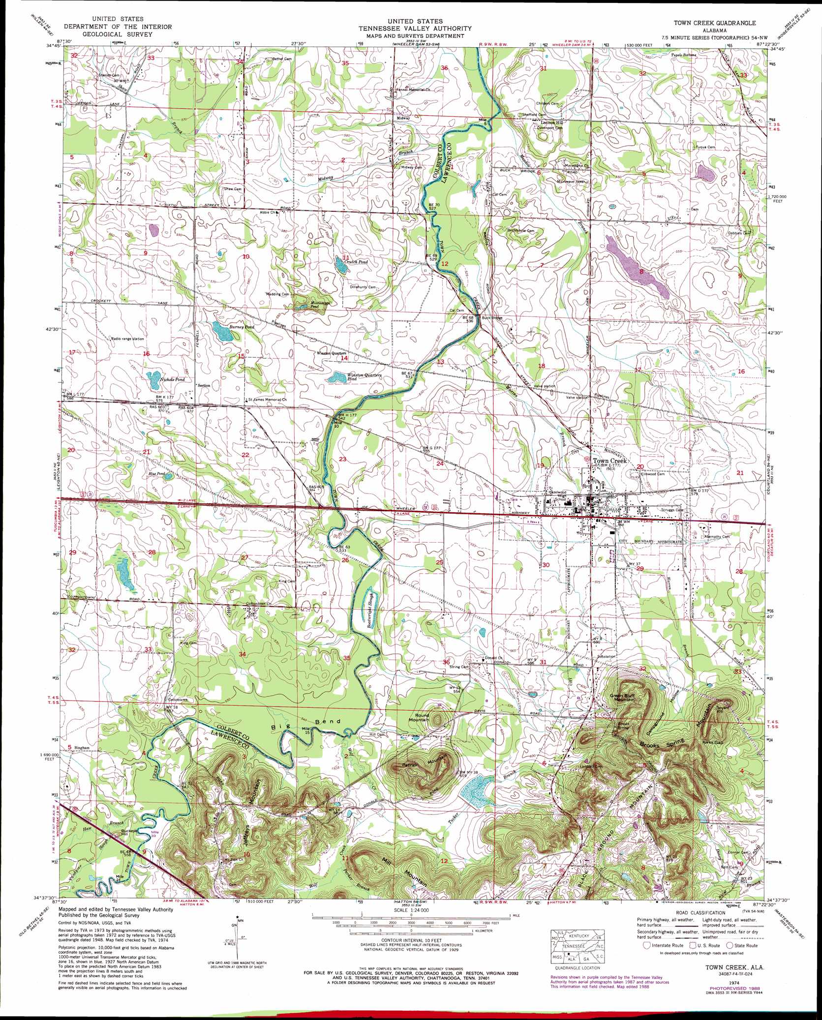
USGS Topo Quad 34087f4 - 1:24,000 scale
| Topo Map Name: | Town Creek |
| USGS Topo Quad ID: | 34087f4 |
| Print Size: | ca. 21 1/4" wide x 27" high |
| Southeast Coordinates: | 34.625° N latitude / 87.375° W longitude |
| Map Center Coordinates: | 34.6875° N latitude / 87.4375° W longitude |
| U.S. State: | AL |
| Filename: | o34087f4.jpg |
| Download Map JPG Image: | Town Creek topo map 1:24,000 scale |
| Map Type: | Topographic |
| Topo Series: | 7.5´ |
| Map Scale: | 1:24,000 |
| Source of Map Images: | United States Geological Survey (USGS) |
| Alternate Map Versions: |
Town Creek AL 1936 Download PDF Buy paper map Town Creek AL 1950 Download PDF Buy paper map Town Creek AL 1974, updated 1975 Download PDF Buy paper map Town Creek AL 1974, updated 1989 Download PDF Buy paper map Town Creek AL 2011 Download PDF Buy paper map Town Creek AL 2014 Download PDF Buy paper map |
1:24,000 Topo Quads surrounding Town Creek
Blackburn |
Pruitton |
Center Hill |
Lexington |
Union Hill |
Florence |
Killen |
Wheeler Dam |
Rogersville |
Cairo |
Tuscumbia |
Leighton |
Town Creek |
Courtland |
Hillsboro |
Russellville |
Old Bethel |
Hatton |
Masterson |
Caddo |
Spruce Pine |
Newburg |
Landersville |
Moulton |
Oakville |
> Back to 34087e1 at 1:100,000 scale
> Back to 34086a1 at 1:250,000 scale
> Back to U.S. Topo Maps home
Town Creek topo map: Gazetteer
Town Creek: Bends
Big Bend elevation 163m 534′Town Creek: Bridges
Buck Bridge elevation 159m 521′King Bridge elevation 162m 531′
Pruett Bridge elevation 159m 521′
Town Creek: Dams
Town Creek Watershed Number 3 elevation 172m 564′Town Creek: Gaps
Kirks Gap elevation 227m 744′Town Creek: Guts
Boatwright Slough elevation 163m 534′Vandyver Slough elevation 167m 547′
Town Creek: Lakes
Blue Pond elevation 173m 567′Brush Pond elevation 173m 567′
Burney Pond elevation 166m 544′
Crutch Pond elevation 167m 547′
Horselot Pond elevation 169m 554′
Johnson Lake elevation 171m 561′
Meadow Pond (historical) elevation 165m 541′
Mississippi Pond elevation 159m 521′
Nichols Pond elevation 173m 567′
Winston Quarters Pond elevation 161m 528′
Town Creek: Populated Places
Bingham elevation 171m 561′Cottontown elevation 173m 567′
Edmond elevation 220m 721′
Lennon Hill elevation 175m 574′
Midway elevation 166m 544′
Section elevation 176m 577′
Shady Grove (historical) elevation 165m 541′
Town Creek elevation 171m 561′
Town Creek: Post Offices
Town Creek Post Office elevation 171m 561′Town Creek: Reservoirs
Knoff Lake elevation 172m 564′Town Creek: Springs
Brooks Spring elevation 209m 685′Pullem Spring elevation 159m 521′
Town Creek: Streams
Bond Branch elevation 165m 541′Haw Branch elevation 165m 541′
Meadow Branch elevation 159m 521′
Midway Branch elevation 159m 521′
Parker Branch elevation 168m 551′
Tucker Branch elevation 165m 541′
Warren Branch elevation 159m 521′
Wolf Creek elevation 162m 531′
Town Creek: Summits
Black Ground Mountain elevation 258m 846′Brooks Spring Mountain elevation 253m 830′
Buckeye Hill elevation 171m 561′
Green Bluff Mountain elevation 251m 823′
Jeffreys Mountain elevation 225m 738′
Mill Mountain elevation 227m 744′
Patrick Mountain elevation 236m 774′
Round Mountain elevation 205m 672′
Town Creek: Valleys
Campground Hollow elevation 184m 603′Town Creek digital topo map on disk
Buy this Town Creek topo map showing relief, roads, GPS coordinates and other geographical features, as a high-resolution digital map file on DVD: