Barton Topo Map Alabama
To zoom in, hover over the map of Barton
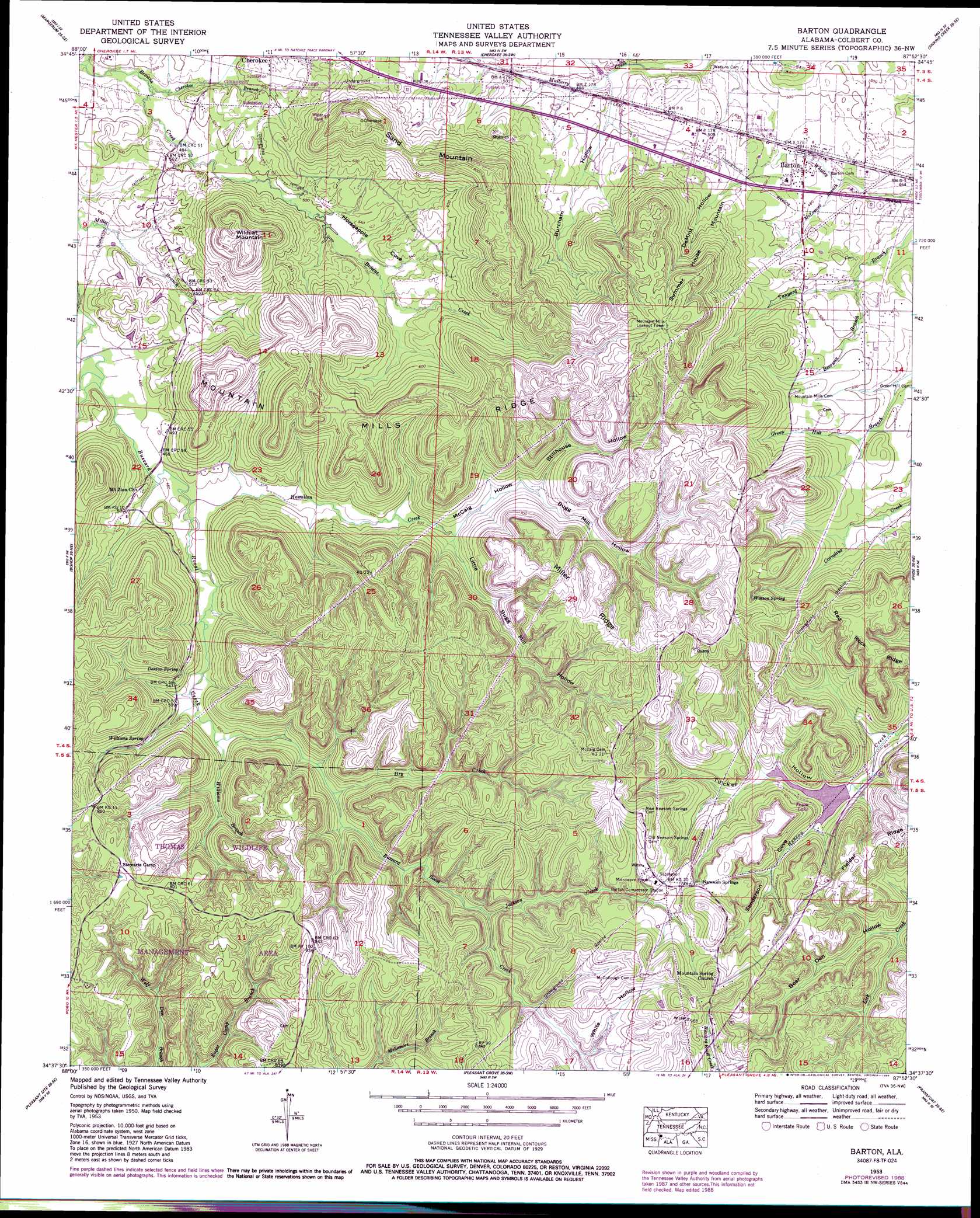
USGS Topo Quad 34087f8 - 1:24,000 scale
| Topo Map Name: | Barton |
| USGS Topo Quad ID: | 34087f8 |
| Print Size: | ca. 21 1/4" wide x 27" high |
| Southeast Coordinates: | 34.625° N latitude / 87.875° W longitude |
| Map Center Coordinates: | 34.6875° N latitude / 87.9375° W longitude |
| U.S. State: | AL |
| Filename: | o34087f8.jpg |
| Download Map JPG Image: | Barton topo map 1:24,000 scale |
| Map Type: | Topographic |
| Topo Series: | 7.5´ |
| Map Scale: | 1:24,000 |
| Source of Map Images: | United States Geological Survey (USGS) |
| Alternate Map Versions: |
Barton AL 1936 Download PDF Buy paper map Barton AL 1953, updated 1974 Download PDF Buy paper map Barton AL 1953, updated 1986 Download PDF Buy paper map Barton AL 1953, updated 1986 Download PDF Buy paper map Barton AL 1953, updated 1989 Download PDF Buy paper map Barton AL 2011 Download PDF Buy paper map Barton AL 2014 Download PDF Buy paper map |
1:24,000 Topo Quads surrounding Barton
Yellow Creek |
Waterloo |
Wright |
Threet |
Blackburn |
Iuka |
Margerum |
Cherokee |
Sinking Creek |
Florence |
Tishomingo |
Bishop |
Barton |
Pride |
Tuscumbia |
Belmont |
Pleasant Site |
Pleasant Grove |
Frankfort |
Russellville |
Red Bay |
Halltown |
Guinn Cross Roads |
Isbell |
Spruce Pine |
> Back to 34087e1 at 1:100,000 scale
> Back to 34086a1 at 1:250,000 scale
> Back to U.S. Topo Maps home
Barton topo map: Gazetteer
Barton: Dams
Fawn Lake Dam elevation 192m 629′Barton: Gaps
The Narrows elevation 175m 574′Barton: Mines
United States Government Quarry elevation 170m 557′Barton: Parks
Thomas State Wildlife Refuge elevation 253m 830′Barton: Populated Places
Barton elevation 147m 482′Mountain Mills (historical) elevation 162m 531′
Newsome Springs elevation 228m 748′
Barton: Post Offices
Dug Post Office elevation 228m 748′Mountain Mills Post Office (historical) elevation 162m 531′
Barton: Reservoirs
Fawn Lake elevation 192m 629′Barton: Ridges
Miller Ridge elevation 245m 803′Mountain Mills Ridge elevation 265m 869′
Red Rock Ridge elevation 275m 902′
Barton: Springs
Cherokee Spring elevation 173m 567′Denton Spring elevation 182m 597′
Newsom Springs elevation 219m 718′
Watson Spring elevation 227m 744′
Williams Spring elevation 184m 603′
Barton: Streams
Beeswax Branch elevation 140m 459′Cherokee Branch elevation 143m 469′
Dry Creek elevation 158m 518′
Hamilton Creek elevation 139m 456′
Jackson Creek elevation 176m 577′
Little Buzzard Roost Creek elevation 138m 452′
McLemore Branch elevation 140m 459′
Miller Branch elevation 136m 446′
Williams Branch elevation 152m 498′
Barton: Summits
Sand Mountain elevation 268m 879′Summer House Mountain elevation 287m 941′
Wildcat Mountain elevation 262m 859′
Barton: Valleys
Bear Den Hollow elevation 172m 564′Bugg Mill Hollow elevation 168m 551′
Burcham Hollow elevation 149m 488′
DeMint Hollow elevation 161m 528′
Horseapple Cove elevation 146m 479′
Little Bugg Mill Hollow elevation 154m 505′
McCaig Hollow elevation 154m 505′
Randolph Hollow elevation 136m 446′
Sanderson Cove elevation 158m 518′
Stillhouse Hollow elevation 165m 541′
Tucker Hollow elevation 158m 518′
White Hollow elevation 198m 649′
Barton digital topo map on disk
Buy this Barton topo map showing relief, roads, GPS coordinates and other geographical features, as a high-resolution digital map file on DVD: