Cherokee Topo Map Alabama
To zoom in, hover over the map of Cherokee
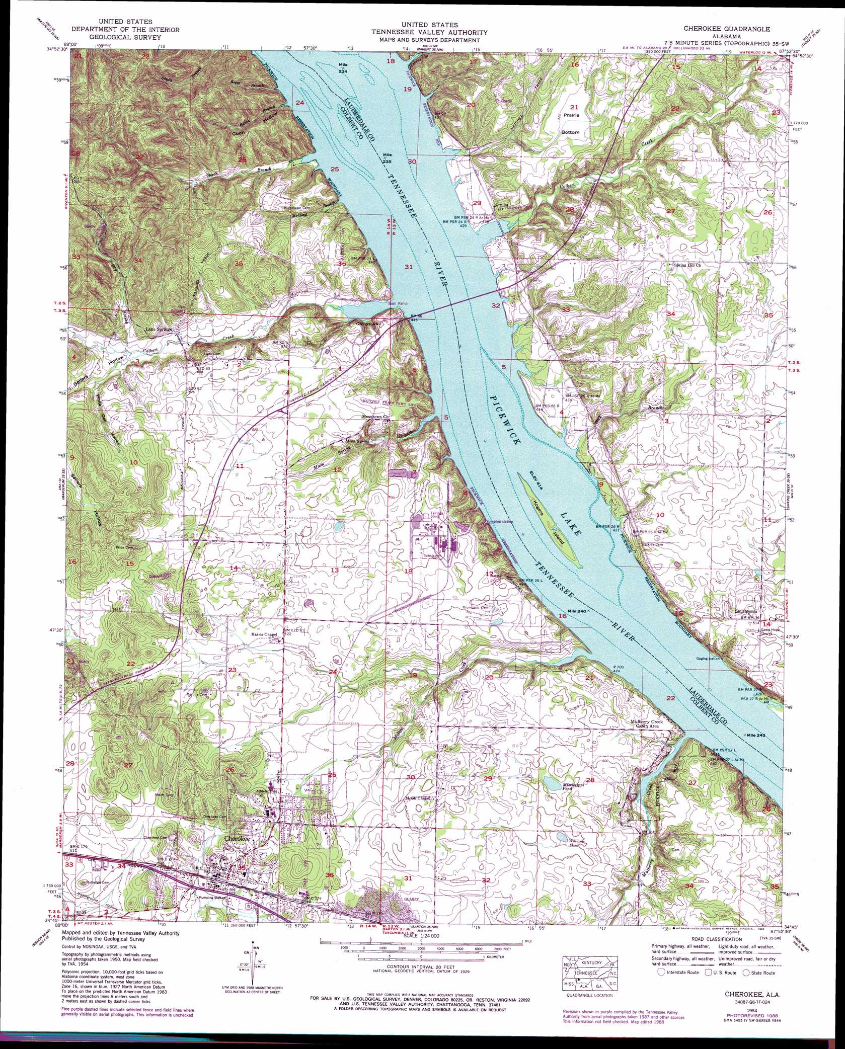
USGS Topo Quad 34087g8 - 1:24,000 scale
| Topo Map Name: | Cherokee |
| USGS Topo Quad ID: | 34087g8 |
| Print Size: | ca. 21 1/4" wide x 27" high |
| Southeast Coordinates: | 34.75° N latitude / 87.875° W longitude |
| Map Center Coordinates: | 34.8125° N latitude / 87.9375° W longitude |
| U.S. State: | AL |
| Filename: | o34087g8.jpg |
| Download Map JPG Image: | Cherokee topo map 1:24,000 scale |
| Map Type: | Topographic |
| Topo Series: | 7.5´ |
| Map Scale: | 1:24,000 |
| Source of Map Images: | United States Geological Survey (USGS) |
| Alternate Map Versions: |
Cherokee AL 1935, updated 1935 Download PDF Buy paper map Cherokee AL 1954, updated 1958 Download PDF Buy paper map Cherokee AL 1954, updated 1974 Download PDF Buy paper map Cherokee AL 1954, updated 1984 Download PDF Buy paper map Cherokee AL 1954, updated 1989 Download PDF Buy paper map Cherokee AL 2011 Download PDF Buy paper map Cherokee AL 2014 Download PDF Buy paper map |
1:24,000 Topo Quads surrounding Cherokee
Pickwick |
Lowryville |
Ransom Stand |
Cypress Inn |
Whitten |
Yellow Creek |
Waterloo |
Wright |
Threet |
Blackburn |
Iuka |
Margerum |
Cherokee |
Sinking Creek |
Florence |
Tishomingo |
Bishop |
Barton |
Pride |
Tuscumbia |
Belmont |
Pleasant Site |
Pleasant Grove |
Frankfort |
Russellville |
> Back to 34087e1 at 1:100,000 scale
> Back to 34086a1 at 1:250,000 scale
> Back to U.S. Topo Maps home
Cherokee topo map: Gazetteer
Cherokee: Bridges
Natchez Trace Parkway Bridge elevation 126m 413′Cherokee: Crossings
Cheathams Ferry (historical) elevation 126m 413′Colberts Ferry (historical) elevation 126m 413′
Georgetown Ferry (historical) elevation 126m 413′
Cherokee: Flats
Prairie Bottom elevation 157m 515′Cherokee: Islands
Colbert Island (historical) elevation 126m 413′Kogers Island elevation 128m 419′
Kogers Rock (historical) elevation 126m 413′
Cherokee: Lakes
Mississippi Pond elevation 142m 465′Williams Pond elevation 149m 488′
Cherokee: Mines
Cherokee Quarry elevation 159m 521′Cherokee: Parks
Natchez Trace Parkway Colbert Ferry Park elevation 131m 429′Natchez Trace Parkway Lauderdale Park elevation 135m 442′
Cherokee: Populated Places
Cherokee elevation 163m 534′Doubleheads Village (historical) elevation 161m 528′
Georgetown elevation 153m 501′
Lane Springs elevation 138m 452′
Mhoontown elevation 158m 518′
Newport (historical) elevation 153m 501′
Smithsonia elevation 157m 515′
Cherokee: Post Offices
Kirk Post Office elevation 158m 518′Newport Post Office (historical) elevation 153m 501′
Cherokee: Springs
Moon Spring elevation 138m 452′Perkins Spring elevation 133m 436′
Cherokee: Streams
Beck Branch elevation 126m 413′Beech Branch elevation 126m 413′
Bevis Branch elevation 130m 426′
Burns Branch elevation 126m 413′
Cave Spring Branch elevation 126m 413′
Colbert Creek elevation 126m 413′
Colbert Creek elevation 126m 413′
Dry Branch elevation 143m 469′
Jenkins Branch elevation 126m 413′
Malone Creek elevation 126m 413′
Medford Branch elevation 126m 413′
Moon Spring Branch elevation 126m 413′
Mulberry Creek elevation 126m 413′
Cherokee: Valleys
Coon Hollow elevation 126m 413′Sellers Hollow elevation 142m 465′
White Oak Hollow elevation 148m 485′
Cherokee digital topo map on disk
Buy this Cherokee topo map showing relief, roads, GPS coordinates and other geographical features, as a high-resolution digital map file on DVD: