Center Hill Topo Map Alabama
To zoom in, hover over the map of Center Hill
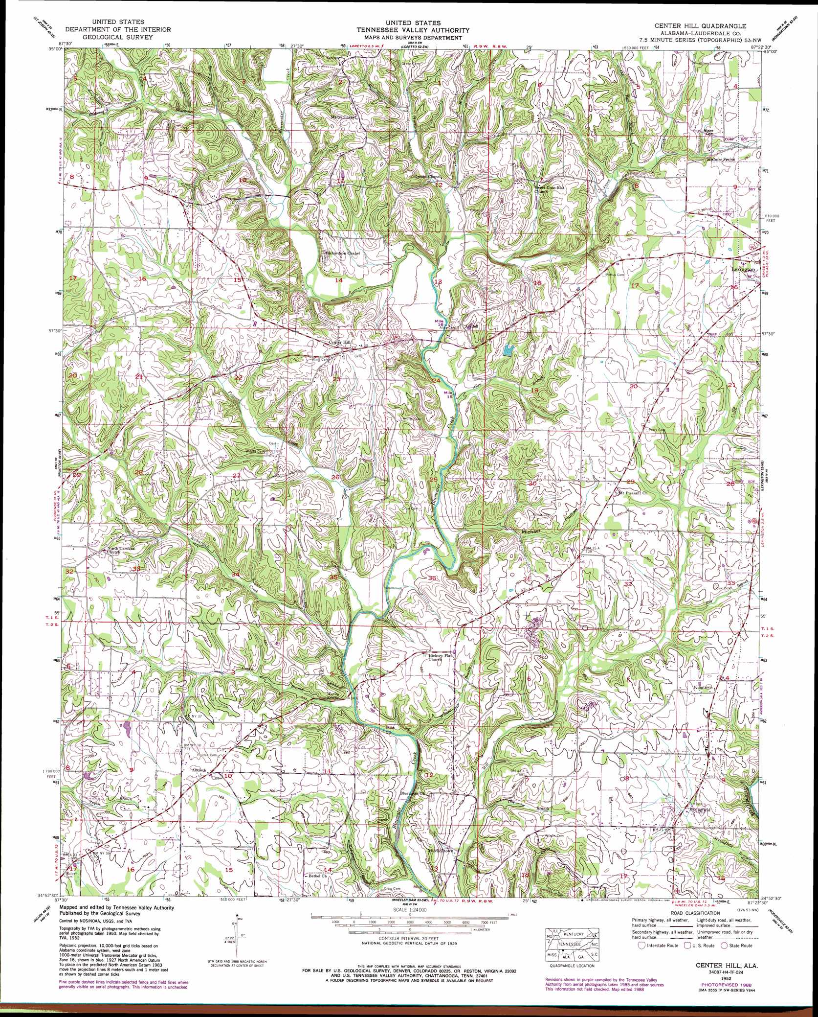
USGS Topo Quad 34087h4 - 1:24,000 scale
| Topo Map Name: | Center Hill |
| USGS Topo Quad ID: | 34087h4 |
| Print Size: | ca. 21 1/4" wide x 27" high |
| Southeast Coordinates: | 34.875° N latitude / 87.375° W longitude |
| Map Center Coordinates: | 34.9375° N latitude / 87.4375° W longitude |
| U.S. State: | AL |
| Filename: | o34087h4.jpg |
| Download Map JPG Image: | Center Hill topo map 1:24,000 scale |
| Map Type: | Topographic |
| Topo Series: | 7.5´ |
| Map Scale: | 1:24,000 |
| Source of Map Images: | United States Geological Survey (USGS) |
| Alternate Map Versions: |
Center Hill AL 1936, updated 1936 Download PDF Buy paper map Center Hill AL 1952, updated 1957 Download PDF Buy paper map Center Hill AL 1952, updated 1973 Download PDF Buy paper map Center Hill AL 1952, updated 1989 Download PDF Buy paper map Center Hill AL 2011 Download PDF Buy paper map Center Hill AL 2014 Download PDF Buy paper map |
1:24,000 Topo Quads surrounding Center Hill
Collinwood |
Westpoint |
Long Branch |
Lawrenceburg |
Bodenham |
Whitten |
Saint Joseph |
Loretto |
Bonnertown |
Appleton |
Blackburn |
Pruitton |
Center Hill |
Lexington |
Union Hill |
Florence |
Killen |
Wheeler Dam |
Rogersville |
Cairo |
Tuscumbia |
Leighton |
Town Creek |
Courtland |
Hillsboro |
> Back to 34087e1 at 1:100,000 scale
> Back to 34086a1 at 1:250,000 scale
> Back to U.S. Topo Maps home
Center Hill topo map: Gazetteer
Center Hill: Parks
Allen Park elevation 208m 682′Center Hill: Populated Places
Antioch elevation 225m 738′Arkdell elevation 200m 656′
Belew (historical) elevation 196m 643′
Center Hill elevation 236m 774′
Comer elevation 213m 698′
Kingtown elevation 218m 715′
Mitchelltown elevation 172m 564′
North Carolina (historical) elevation 225m 738′
Palestine (historical) elevation 214m 702′
Posey (historical) elevation 185m 606′
Slabtown (historical) elevation 191m 626′
Springfield elevation 194m 636′
Sweet Gum elevation 229m 751′
Center Hill: Post Offices
Arkdell Post Office (historical) elevation 201m 659′Belew Post Office (historical) elevation 196m 643′
Comer Post Office elevation 213m 698′
Center Hill: Springs
McGuire Spring elevation 219m 718′Needmore Spring elevation 232m 761′
Posehill Springs elevation 185m 606′
Worley Spring elevation 174m 570′
Center Hill: Streams
Allen Branch elevation 179m 587′Camp Branch elevation 168m 551′
Dog Branch elevation 171m 561′
Dry Branch elevation 192m 629′
Hurricane Creek elevation 183m 600′
Jordan Branch elevation 164m 538′
Keaty Branch elevation 200m 656′
Little Bluewater Creek elevation 188m 616′
Little Bluewater Creek elevation 188m 616′
Little Bluewater Creek elevation 181m 593′
Little Bluewater Creek elevation 181m 593′
McPeters Branch elevation 169m 554′
Old Fall Branch elevation 205m 672′
Possum Creek elevation 171m 561′
Richardson Creek elevation 179m 587′
Shakerag Branch elevation 199m 652′
Taylor Branch elevation 185m 606′
Walton Branch elevation 166m 544′
Center Hill: Valleys
Michael Hollow elevation 178m 583′Center Hill digital topo map on disk
Buy this Center Hill topo map showing relief, roads, GPS coordinates and other geographical features, as a high-resolution digital map file on DVD: