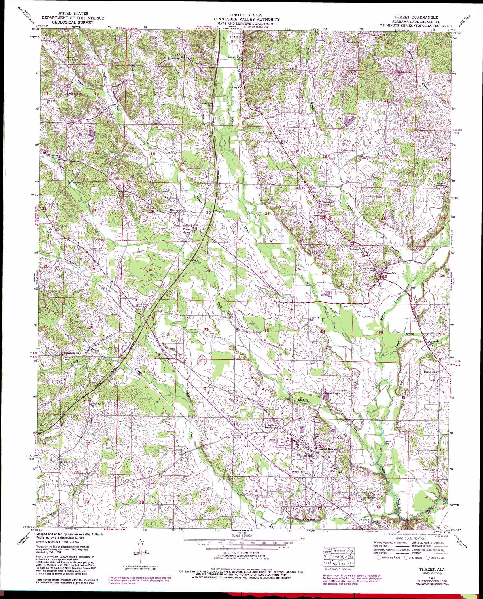
Threet Topo Map Alabama
To zoom in, hover over the map of Threet
USGS Topo Quad 34087h7 - 1:24,000 scale
| Topo Map Name: | Threet |
| USGS Topo Quad ID: | 34087h7 |
| Print Size: | ca. 21 1/4" wide x 27" high |
| Southeast Coordinates: | 34.875° N latitude / 87.75° W longitude |
| Map Center Coordinates: | 34.9375° N latitude / 87.8125° W longitude |
| U.S. State: | AL |
| Filename: | o34087h7.jpg |
| Download Map JPG Image: | Threet topo map 1:24,000 scale |
| Map Type: | Topographic |
| Topo Series: | 7.5´ |
| Map Scale: | 1:24,000 |
| Source of Map Images: | United States Geological Survey (USGS) |
| Alternate Map Versions: |
Threet AL 1936 Download PDF Buy paper map Threet AL 1954, updated 1958 Download PDF Buy paper map Threet AL 1954, updated 1973 Download PDF Buy paper map Threet AL 1954, updated 1977 Download PDF Buy paper map Threet AL 1954, updated 1988 Download PDF Buy paper map Threet AL 2011 Download PDF Buy paper map Threet AL 2014 Download PDF Buy paper map |
1:24,000 Topo Quads surrounding Threet
Wolf Pit Ridge |
Martins Mills |
Three Churches |
Collinwood |
Westpoint |
Lowryville |
Ransom Stand |
Cypress Inn |
Whitten |
Saint Joseph |
Waterloo |
Wright |
Threet |
Blackburn |
Pruitton |
Margerum |
Cherokee |
Sinking Creek |
Florence |
Killen |
Bishop |
Barton |
Pride |
Tuscumbia |
Leighton |
> Back to 34087e1 at 1:100,000 scale
> Back to 34086a1 at 1:250,000 scale
> Back to U.S. Topo Maps home
Threet topo map: Gazetteer
Threet: Dams
Emmett Abramson Lake Dam elevation 207m 679′Threet: Lakes
Abramson Lake elevation 200m 656′Threet: Populated Places
Central Heights elevation 186m 610′Cloverdale elevation 182m 597′
Johnson Crossroads elevation 194m 636′
Melvin (historical) elevation 193m 633′
Stewartville elevation 217m 711′
Sullivan Crossroads elevation 186m 610′
Threet elevation 196m 643′
Threet: Post Offices
Birchum Post Office (historical) elevation 220m 721′Burcham Mills Post Office (historical) elevation 153m 501′
Threet: Streams
Box Branch elevation 165m 541′Bruton Branch elevation 177m 580′
Burcham Creek elevation 152m 498′
Cooper Branch elevation 209m 685′
Cooper Branch elevation 209m 685′
Greenbrier Branch elevation 168m 551′
Greenbrier Branch elevation 168m 551′
Hurricane Creek elevation 174m 570′
Lindsey Creek elevation 156m 511′
Middle Cypress Creek elevation 161m 528′
North Fork Cypress Creek elevation 178m 583′
Oakley Springs Branch elevation 161m 528′
Threet Creek elevation 174m 570′
Threet Creek elevation 174m 570′
Threet digital topo map on disk
Buy this Threet topo map showing relief, roads, GPS coordinates and other geographical features, as a high-resolution digital map file on DVD: