Pleasant Ridge Topo Map Mississippi
To zoom in, hover over the map of Pleasant Ridge
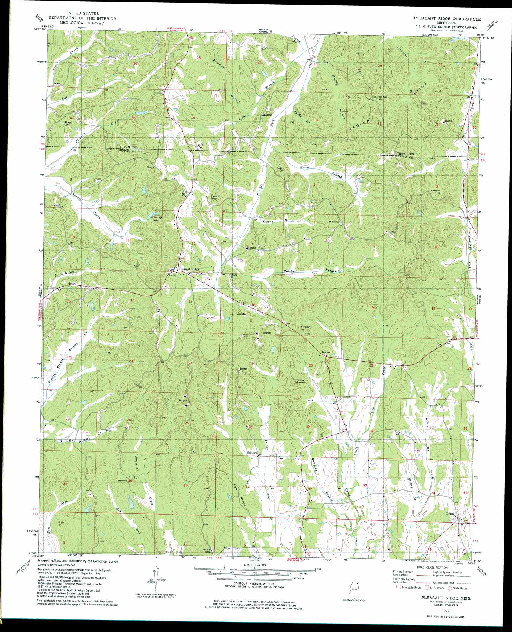
USGS Topo Quad 34088e7 - 1:24,000 scale
| Topo Map Name: | Pleasant Ridge |
| USGS Topo Quad ID: | 34088e7 |
| Print Size: | ca. 21 1/4" wide x 27" high |
| Southeast Coordinates: | 34.5° N latitude / 88.75° W longitude |
| Map Center Coordinates: | 34.5625° N latitude / 88.8125° W longitude |
| U.S. State: | MS |
| Filename: | o34088e7.jpg |
| Download Map JPG Image: | Pleasant Ridge topo map 1:24,000 scale |
| Map Type: | Topographic |
| Topo Series: | 7.5´ |
| Map Scale: | 1:24,000 |
| Source of Map Images: | United States Geological Survey (USGS) |
| Alternate Map Versions: |
Pleasant Ridge MS 1982, updated 1983 Download PDF Buy paper map Pleasant Ridge MS 2012 Download PDF Buy paper map Pleasant Ridge MS 2015 Download PDF Buy paper map |
1:24,000 Topo Quads surrounding Pleasant Ridge
Whitten Town |
Falkner |
Peoples |
Kossuth South |
Rienzi |
Blue Mountain |
Ripley |
Dumas |
Jumpertown |
Booneville |
Myrtle |
Keownville |
Pleasant Ridge |
Baldwyn |
Wheeler |
New Albany West |
New Albany East |
Ellistown |
Guntown |
Ratliff |
Northwest Pontotoc |
Northeast Pontotoc |
Sherman |
Tupelo |
Mooreville |
> Back to 34088e1 at 1:100,000 scale
> Back to 34088a1 at 1:250,000 scale
> Back to U.S. Topo Maps home
Pleasant Ridge topo map: Gazetteer
Pleasant Ridge: Dams
Union County Lake Dam elevation 146m 479′Pleasant Ridge: Populated Places
Graham elevation 165m 541′Halltown elevation 136m 446′
Jericho elevation 135m 442′
Locum elevation 190m 623′
Pleasant Ridge elevation 188m 616′
Pleasant Ridge: Reservoirs
County Lake elevation 141m 462′Pleasant Ridge: Ridges
Pea Ridge elevation 146m 479′Pleasant Ridge: Streams
Caney Branch elevation 154m 505′Foshea Branch elevation 152m 498′
Freeman Branch elevation 162m 531′
Hatchie Branch elevation 161m 528′
Hickey Branch elevation 121m 396′
Little Camp Creek elevation 126m 413′
Moore Branch elevation 155m 508′
Murley Branch elevation 150m 492′
Owens Branch elevation 161m 528′
Rampley Branch elevation 119m 390′
Stubb Branch elevation 152m 498′
Pleasant Ridge: Summits
Davis Hill elevation 189m 620′Oak Mill Hill elevation 208m 682′
Rockpile Hill elevation 210m 688′
Sapling Mountain elevation 182m 597′
Sweden Hill elevation 190m 623′
Pleasant Ridge digital topo map on disk
Buy this Pleasant Ridge topo map showing relief, roads, GPS coordinates and other geographical features, as a high-resolution digital map file on DVD: