Keownville Topo Map Mississippi
To zoom in, hover over the map of Keownville
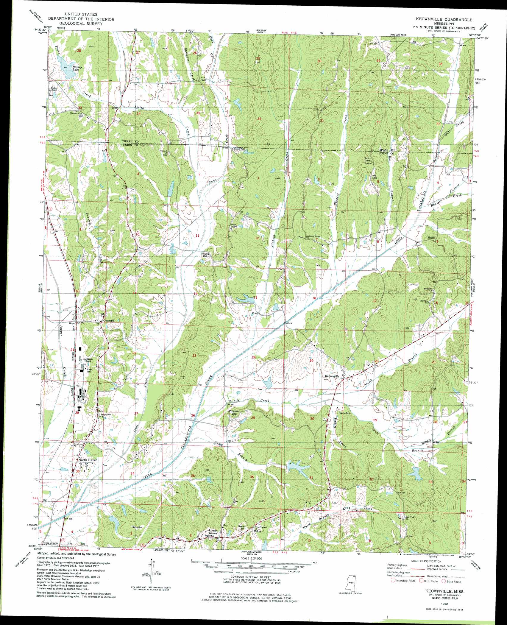
USGS Topo Quad 34088e8 - 1:24,000 scale
| Topo Map Name: | Keownville |
| USGS Topo Quad ID: | 34088e8 |
| Print Size: | ca. 21 1/4" wide x 27" high |
| Southeast Coordinates: | 34.5° N latitude / 88.875° W longitude |
| Map Center Coordinates: | 34.5625° N latitude / 88.9375° W longitude |
| U.S. State: | MS |
| Filename: | o34088e8.jpg |
| Download Map JPG Image: | Keownville topo map 1:24,000 scale |
| Map Type: | Topographic |
| Topo Series: | 7.5´ |
| Map Scale: | 1:24,000 |
| Source of Map Images: | United States Geological Survey (USGS) |
| Alternate Map Versions: |
Keownville MS 1982, updated 1983 Download PDF Buy paper map Keownville MS 2012 Download PDF Buy paper map Keownville MS 2015 Download PDF Buy paper map |
1:24,000 Topo Quads surrounding Keownville
Ashland |
Whitten Town |
Falkner |
Peoples |
Kossuth South |
Chilli Creek |
Blue Mountain |
Ripley |
Dumas |
Jumpertown |
Hickory Flat |
Myrtle |
Keownville |
Pleasant Ridge |
Baldwyn |
Etta |
New Albany West |
New Albany East |
Ellistown |
Guntown |
Thaxton |
Northwest Pontotoc |
Northeast Pontotoc |
Sherman |
Tupelo |
> Back to 34088e1 at 1:100,000 scale
> Back to 34088a1 at 1:250,000 scale
> Back to U.S. Topo Maps home
Keownville topo map: Gazetteer
Keownville: Dams
Baker Lake Dam elevation 141m 462′Ellis Lake Dam elevation 122m 400′
Kitchings Lake Dam elevation 122m 400′
Roger Elder Pond Dam elevation 132m 433′
Roy Jordan Lake Dam elevation 128m 419′
Tate Lake Dam elevation 119m 390′
Utley Lake Dam elevation 114m 374′
Keownville: Populated Places
Baker elevation 154m 505′Bluff elevation 131m 429′
Concord elevation 140m 459′
Keownville elevation 122m 400′
Locust Grove elevation 155m 508′
Molino elevation 120m 393′
North Haven elevation 116m 380′
Pleasant Hill elevation 134m 439′
Keownville: Reservoirs
Rainey Lake elevation 128m 419′Keownville: Streams
Bumpass Creek elevation 117m 383′Bussel Creek elevation 122m 400′
Camp Branch elevation 105m 344′
Cane Creek elevation 101m 331′
Cook Creek elevation 116m 380′
Daniel Creek elevation 115m 377′
Foley Creek elevation 121m 396′
Hall Creek elevation 128m 419′
Little Creek elevation 133m 436′
McAllister Creek elevation 104m 341′
Middle Branch Wilhite Creek elevation 121m 396′
North Branch Wilhite Creek elevation 114m 374′
Pickens Creek elevation 119m 390′
Pinhook Creek elevation 110m 360′
Possum Creek elevation 111m 364′
Smith Creek elevation 113m 370′
South Branch Wilhite Creek elevation 114m 374′
Spencer Creek elevation 115m 377′
Walker Creek elevation 124m 406′
Wilhite Creek elevation 106m 347′
Keownville digital topo map on disk
Buy this Keownville topo map showing relief, roads, GPS coordinates and other geographical features, as a high-resolution digital map file on DVD: