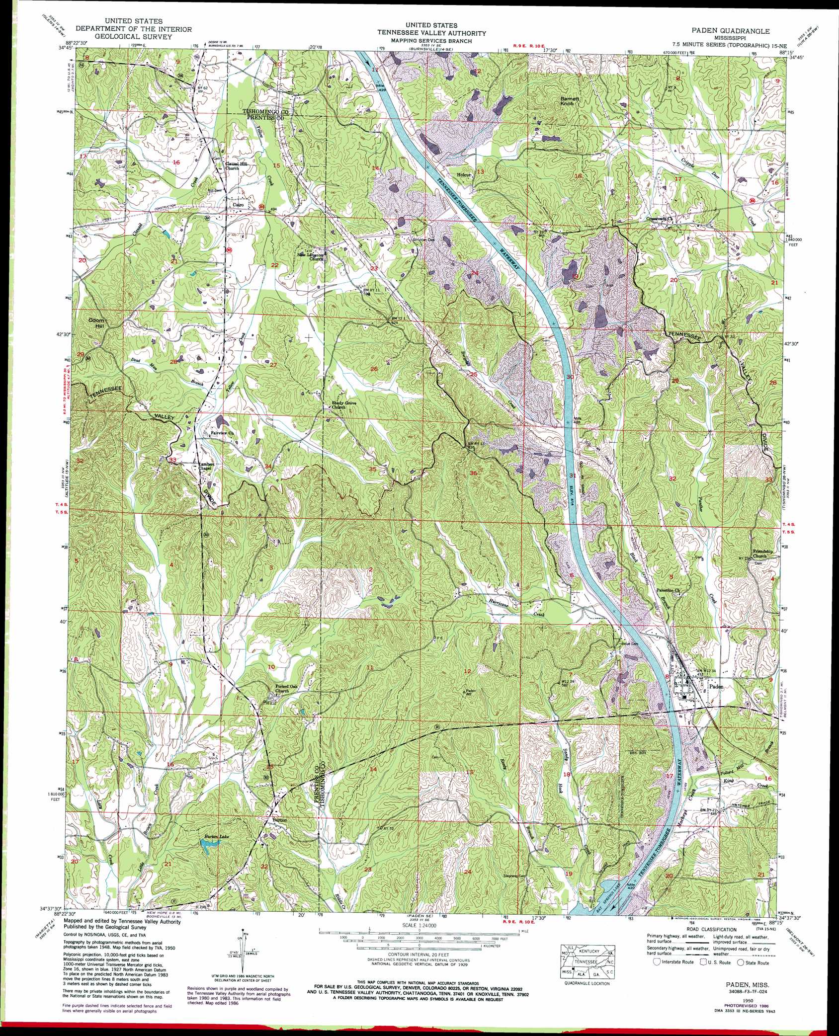
Paden Topo Map Mississippi
To zoom in, hover over the map of Paden
USGS Topo Quad 34088f3 - 1:24,000 scale
| Topo Map Name: | Paden |
| USGS Topo Quad ID: | 34088f3 |
| Print Size: | ca. 21 1/4" wide x 27" high |
| Southeast Coordinates: | 34.625° N latitude / 88.25° W longitude |
| Map Center Coordinates: | 34.6875° N latitude / 88.3125° W longitude |
| U.S. State: | MS |
| Filename: | o34088f3.jpg |
| Download Map JPG Image: | Paden topo map 1:24,000 scale |
| Map Type: | Topographic |
| Topo Series: | 7.5´ |
| Map Scale: | 1:24,000 |
| Source of Map Images: | United States Geological Survey (USGS) |
| Alternate Map Versions: |
Holcut MS 1935 Download PDF Buy paper map Paden MS 1950, updated 1954 Download PDF Buy paper map Paden MS 1950, updated 1971 Download PDF Buy paper map Paden MS 1950, updated 1986 Download PDF Buy paper map Paden MS 2012 Download PDF Buy paper map Paden MS 2015 Download PDF Buy paper map |
1:24,000 Topo Quads surrounding Paden
Corinth |
Kendrick |
Doskie |
Yellow Creek |
Waterloo |
Rienzi |
Glens |
Burnsville |
Iuka |
Margerum |
Booneville |
Altitude |
Paden |
Tishomingo |
Bishop |
Wheeler |
Marietta |
Paden Se |
Belmont |
Pleasant Site |
Ratliff |
Kirkville |
Fulton Ne |
Red Bay |
Halltown |
> Back to 34088e1 at 1:100,000 scale
> Back to 34088a1 at 1:250,000 scale
> Back to U.S. Topo Maps home
Paden topo map: Gazetteer
Paden: Canals
Mackys Creek Canal elevation 124m 406′Paden: Flats
Clausel Hill Bottom elevation 146m 479′Paden: Parks
Divide Overlook Area elevation 155m 508′Paden Overlook Area elevation 159m 521′
Paden: Populated Places
Burton elevation 153m 501′Cairo elevation 159m 521′
Holcut elevation 164m 538′
Paden elevation 138m 452′
Paden: Post Offices
Burnt Mills Post Office (historical) elevation 184m 603′Paden: Reservoirs
Burton Lake elevation 122m 400′Paden: Streams
Barnett Branch elevation 146m 479′Black Branch elevation 123m 403′
Burgess Creek elevation 125m 410′
Clausel Creek elevation 143m 469′
Dead Man Branch elevation 152m 498′
Hurrican Branch elevation 150m 492′
Hurricane Creek elevation 124m 406′
King Creek elevation 127m 416′
Panther Creek elevation 124m 406′
Pollard Mill Branch elevation 126m 413′
Reedy Branch elevation 126m 413′
Paden: Summits
Barnett Knob elevation 218m 715′Odom Hill elevation 196m 643′
Paden digital topo map on disk
Buy this Paden topo map showing relief, roads, GPS coordinates and other geographical features, as a high-resolution digital map file on DVD: