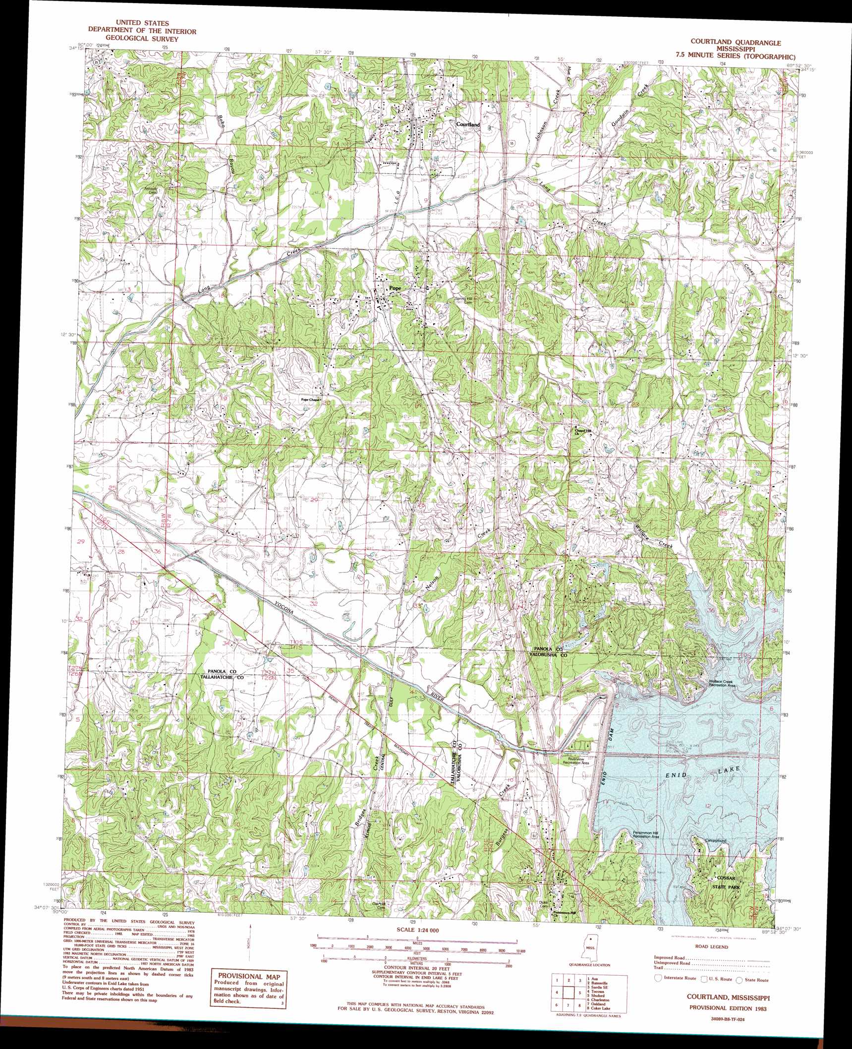
Courtland Topo Map Mississippi
To zoom in, hover over the map of Courtland
USGS Topo Quad 34089b8 - 1:24,000 scale
| Topo Map Name: | Courtland |
| USGS Topo Quad ID: | 34089b8 |
| Print Size: | ca. 21 1/4" wide x 27" high |
| Southeast Coordinates: | 34.125° N latitude / 89.875° W longitude |
| Map Center Coordinates: | 34.1875° N latitude / 89.9375° W longitude |
| U.S. State: | MS |
| Filename: | o34089b8.jpg |
| Download Map JPG Image: | Courtland topo map 1:24,000 scale |
| Map Type: | Topographic |
| Topo Series: | 7.5´ |
| Map Scale: | 1:24,000 |
| Source of Map Images: | United States Geological Survey (USGS) |
| Alternate Map Versions: |
Courtland MS 1983, updated 1983 Download PDF Buy paper map Courtland MS 1983, updated 1983 Download PDF Buy paper map Courtland MS 2012 Download PDF Buy paper map Courtland MS 2015 Download PDF Buy paper map |
1:24,000 Topo Quads surrounding Courtland
Crenshaw South |
Pleasant Grove |
Sardis |
Sardis Dam |
Coles Point |
Curtis Station |
Asa |
Batesville |
Sardis Se |
Splinter |
Crowder |
Tocowa |
Courtland |
Shuford |
Water Valley West |
Fishhook Lake |
Charleston |
Oakland |
Coker Lake |
Velma |
Tippo |
Paynes |
Tillatoba |
Scobey |
Coffeeville |
> Back to 34089a1 at 1:100,000 scale
> Back to 34088a1 at 1:250,000 scale
> Back to U.S. Topo Maps home
Courtland topo map: Gazetteer
Courtland: Crossings
Interchange 233 elevation 71m 232′Interchange 237 elevation 73m 239′
Courtland: Dams
Enid Dam elevation 86m 282′Courtland: Parks
Cossar State Park elevation 84m 275′Persimmon Hill Recreation Area elevation 81m 265′
Riverview Recreation Area elevation 62m 203′
Wallace Creek Recreation Area elevation 78m 255′
Courtland: Populated Places
Courtland elevation 77m 252′Hubbard Creek elevation 83m 272′
Pope elevation 69m 226′
Wallace Creek elevation 90m 295′
Courtland: Reservoirs
Enid Lake elevation 86m 282′Courtland: Ridges
Yocona Ridge elevation 86m 282′Courtland: Streams
Bean Creek elevation 74m 242′Bobo Bayou elevation 59m 193′
Bridges Creek elevation 59m 193′
Burgess Creek elevation 58m 190′
Caney Creek elevation 72m 236′
Goodwin Creek elevation 69m 226′
Hubbard Creek elevation 74m 242′
Hurt Creek elevation 68m 223′
Johnson Creek elevation 67m 219′
Long Creek elevation 72m 236′
Nelson Creek elevation 58m 190′
Wallace Creek elevation 74m 242′
Courtland: Summits
Persimmon Hill elevation 91m 298′Courtland digital topo map on disk
Buy this Courtland topo map showing relief, roads, GPS coordinates and other geographical features, as a high-resolution digital map file on DVD: