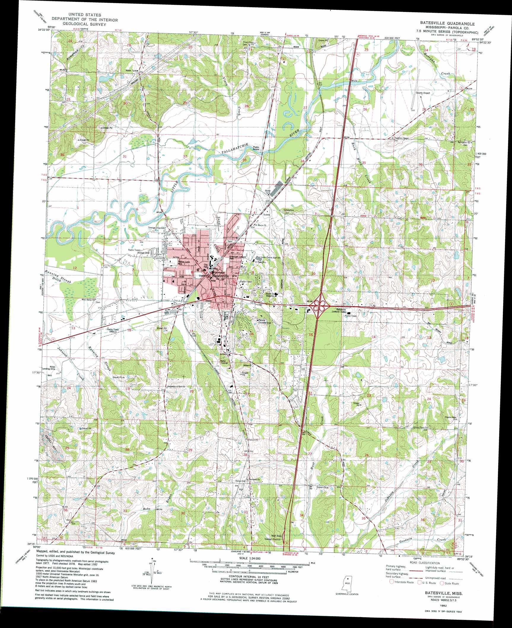
Batesville Topo Map Mississippi
To zoom in, hover over the map of Batesville
USGS Topo Quad 34089c8 - 1:24,000 scale
| Topo Map Name: | Batesville |
| USGS Topo Quad ID: | 34089c8 |
| Print Size: | ca. 21 1/4" wide x 27" high |
| Southeast Coordinates: | 34.25° N latitude / 89.875° W longitude |
| Map Center Coordinates: | 34.3125° N latitude / 89.9375° W longitude |
| U.S. State: | MS |
| Filename: | o34089c8.jpg |
| Download Map JPG Image: | Batesville topo map 1:24,000 scale |
| Map Type: | Topographic |
| Topo Series: | 7.5´ |
| Map Scale: | 1:24,000 |
| Source of Map Images: | United States Geological Survey (USGS) |
| Alternate Map Versions: |
Sardis SW MS 1975, updated 1976 Download PDF Buy paper map Batesville MS 1982, updated 1982 Download PDF Buy paper map Batesville MS 2012 Download PDF Buy paper map Batesville MS 2015 Download PDF Buy paper map |
1:24,000 Topo Quads surrounding Batesville
Crenshaw North |
Longtown |
Senatobia |
Looxahoma |
Tyro |
Crenshaw South |
Pleasant Grove |
Sardis |
Sardis Dam |
Coles Point |
Curtis Station |
Asa |
Batesville |
Sardis Se |
Splinter |
Crowder |
Tocowa |
Courtland |
Shuford |
Water Valley West |
Fishhook Lake |
Charleston |
Oakland |
Coker Lake |
Velma |
> Back to 34089a1 at 1:100,000 scale
> Back to 34088a1 at 1:250,000 scale
> Back to U.S. Topo Maps home
Batesville topo map: Gazetteer
Batesville: Airports
Noles Landing Strip elevation 63m 206′Panola County Airport elevation 61m 200′
Batesville: Crossings
Interchange 243 elevation 94m 308′Interchange 246 elevation 69m 226′
Batesville: Dams
J H McGee Pond Dam elevation 71m 232′Mississippi No Name 220 Dam elevation 100m 328′
Mrs A S Kyle Pond Dam elevation 107m 351′
T A Lemaster Pond Dam elevation 85m 278′
Batesville: Parks
American League Park elevation 66m 216′Patton Lane Park elevation 64m 209′
Batesville: Populated Places
Batesville elevation 71m 232′Batesville: Streams
Buck Horn Creek elevation 59m 193′Sand Creek elevation 58m 190′
Viney Creek elevation 57m 187′
Batesville digital topo map on disk
Buy this Batesville topo map showing relief, roads, GPS coordinates and other geographical features, as a high-resolution digital map file on DVD: