Bagley Lake Topo Map Mississippi
To zoom in, hover over the map of Bagley Lake
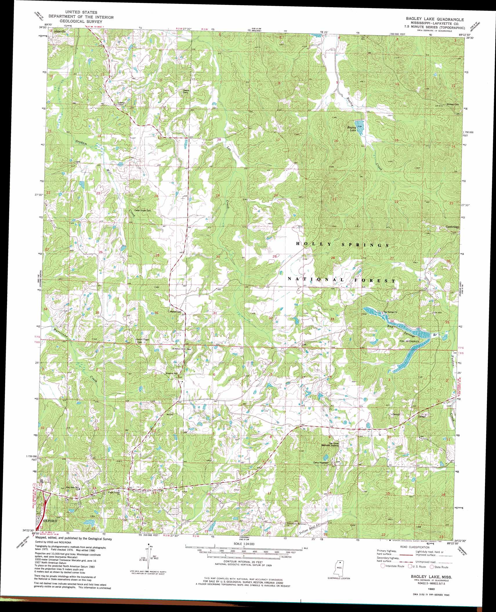
USGS Topo Quad 34089d4 - 1:24,000 scale
| Topo Map Name: | Bagley Lake |
| USGS Topo Quad ID: | 34089d4 |
| Print Size: | ca. 21 1/4" wide x 27" high |
| Southeast Coordinates: | 34.375° N latitude / 89.375° W longitude |
| Map Center Coordinates: | 34.4375° N latitude / 89.4375° W longitude |
| U.S. State: | MS |
| Filename: | o34089d4.jpg |
| Download Map JPG Image: | Bagley Lake topo map 1:24,000 scale |
| Map Type: | Topographic |
| Topo Series: | 7.5´ |
| Map Scale: | 1:24,000 |
| Source of Map Images: | United States Geological Survey (USGS) |
| Alternate Map Versions: |
Bagley Lake MS 1980, updated 1981 Download PDF Buy paper map Bagley Lake MS 2000, updated 2003 Download PDF Buy paper map Bagley Lake MS 2012 Download PDF Buy paper map Bagley Lake MS 2015 Download PDF Buy paper map |
| FStopo: | US Forest Service topo Bagley Lake is available: Download FStopo PDF Download FStopo TIF |
1:24,000 Topo Quads surrounding Bagley Lake
Wyatte |
Marianna |
Waterford |
Potts Camp |
Chilli Creek |
Tyro |
Laws Hill |
Malone |
Bethlehem |
Hickory Flat |
Coles Point |
Oxford North |
Bagley Lake |
Puskus Lake |
Etta |
Splinter |
Oxford South |
Yocona |
Denmark |
Thaxton |
Water Valley West |
Water Valley East |
Paris |
Tula |
Randolph |
> Back to 34089a1 at 1:100,000 scale
> Back to 34088a1 at 1:250,000 scale
> Back to U.S. Topo Maps home
Bagley Lake topo map: Gazetteer
Bagley Lake: Dams
Avent Lake Dam elevation 149m 488′Brazil Lake Dam elevation 129m 423′
Gunter Lake Dam elevation 124m 406′
LT 15-1 Dam elevation 98m 321′
Stuart Lake Dam elevation 121m 396′
Bagley Lake: Populated Places
Woodland Hills Estates elevation 155m 508′Bagley Lake: Reservoirs
Bagley Lake elevation 104m 341′Bagley Lake: Streams
Bay Springs Branch elevation 121m 396′Bagley Lake digital topo map on disk
Buy this Bagley Lake topo map showing relief, roads, GPS coordinates and other geographical features, as a high-resolution digital map file on DVD: