Myrtle Topo Map Mississippi
To zoom in, hover over the map of Myrtle
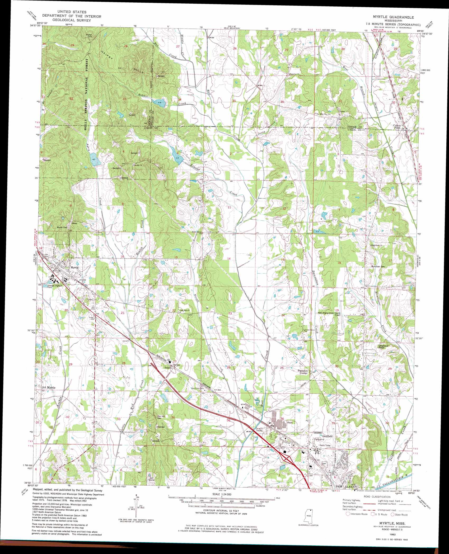
USGS Topo Quad 34089e1 - 1:24,000 scale
| Topo Map Name: | Myrtle |
| USGS Topo Quad ID: | 34089e1 |
| Print Size: | ca. 21 1/4" wide x 27" high |
| Southeast Coordinates: | 34.5° N latitude / 89° W longitude |
| Map Center Coordinates: | 34.5625° N latitude / 89.0625° W longitude |
| U.S. State: | MS |
| Filename: | o34089e1.jpg |
| Download Map JPG Image: | Myrtle topo map 1:24,000 scale |
| Map Type: | Topographic |
| Topo Series: | 7.5´ |
| Map Scale: | 1:24,000 |
| Source of Map Images: | United States Geological Survey (USGS) |
| Alternate Map Versions: |
Myrtle MS 1982, updated 1983 Download PDF Buy paper map Myrtle MS 2000, updated 2003 Download PDF Buy paper map Myrtle MS 2012 Download PDF Buy paper map Myrtle MS 2015 Download PDF Buy paper map |
| FStopo: | US Forest Service topo Myrtle is available: Download FStopo PDF Download FStopo TIF |
1:24,000 Topo Quads surrounding Myrtle
Holly Springs Se |
Ashland |
Whitten Town |
Falkner |
Peoples |
Potts Camp |
Chilli Creek |
Blue Mountain |
Ripley |
Dumas |
Bethlehem |
Hickory Flat |
Myrtle |
Keownville |
Pleasant Ridge |
Puskus Lake |
Etta |
New Albany West |
New Albany East |
Ellistown |
Denmark |
Thaxton |
Northwest Pontotoc |
Northeast Pontotoc |
Sherman |
> Back to 34089e1 at 1:100,000 scale
> Back to 34088a1 at 1:250,000 scale
> Back to U.S. Topo Maps home
Myrtle topo map: Gazetteer
Myrtle: Airports
New Albany-Union Co Airport elevation 125m 410′Myrtle: Dams
Ayers Watershed UT-4-1 Dam elevation 129m 423′Bagwell Lake Dam elevation 128m 419′
Craig Lake elevation 116m 380′
Hell Creek Structure LT-9b-2 Dam elevation 128m 419′
Hell Creek Watershed LT-9b-3 Dam elevation 129m 423′
Jack Dowdy Pond Dam elevation 120m 393′
Roberts Lake Dam elevation 113m 370′
Wicker Lake Dam elevation 125m 410′
Wicker Lake Dam elevation 128m 419′
Myrtle: Populated Places
Cotton Plant elevation 128m 419′Glenfield elevation 120m 393′
Myrtle elevation 122m 400′
Old Myrtle elevation 119m 390′
Pumpkin Center elevation 116m 380′
Shari elevation 112m 367′
Smalco elevation 122m 400′
Myrtle: Reservoirs
Ayers Lake elevation 129m 423′Myrtle: Streams
Ayers Creek elevation 115m 377′Beulah Creek elevation 113m 370′
Box Creek elevation 123m 403′
Damnation Creek elevation 102m 334′
Frazier Creek elevation 110m 360′
Guyton Creek elevation 119m 390′
Jasper Creek elevation 97m 318′
Jenny Branch elevation 113m 370′
Middle Creek elevation 119m 390′
Novell Creek elevation 103m 337′
Robbin Creek elevation 119m 390′
West Branch Jasper Creek elevation 116m 380′
Myrtle: Summits
Heipsy Hills elevation 154m 505′Myrtle digital topo map on disk
Buy this Myrtle topo map showing relief, roads, GPS coordinates and other geographical features, as a high-resolution digital map file on DVD: