Looxahoma Topo Map Mississippi
To zoom in, hover over the map of Looxahoma
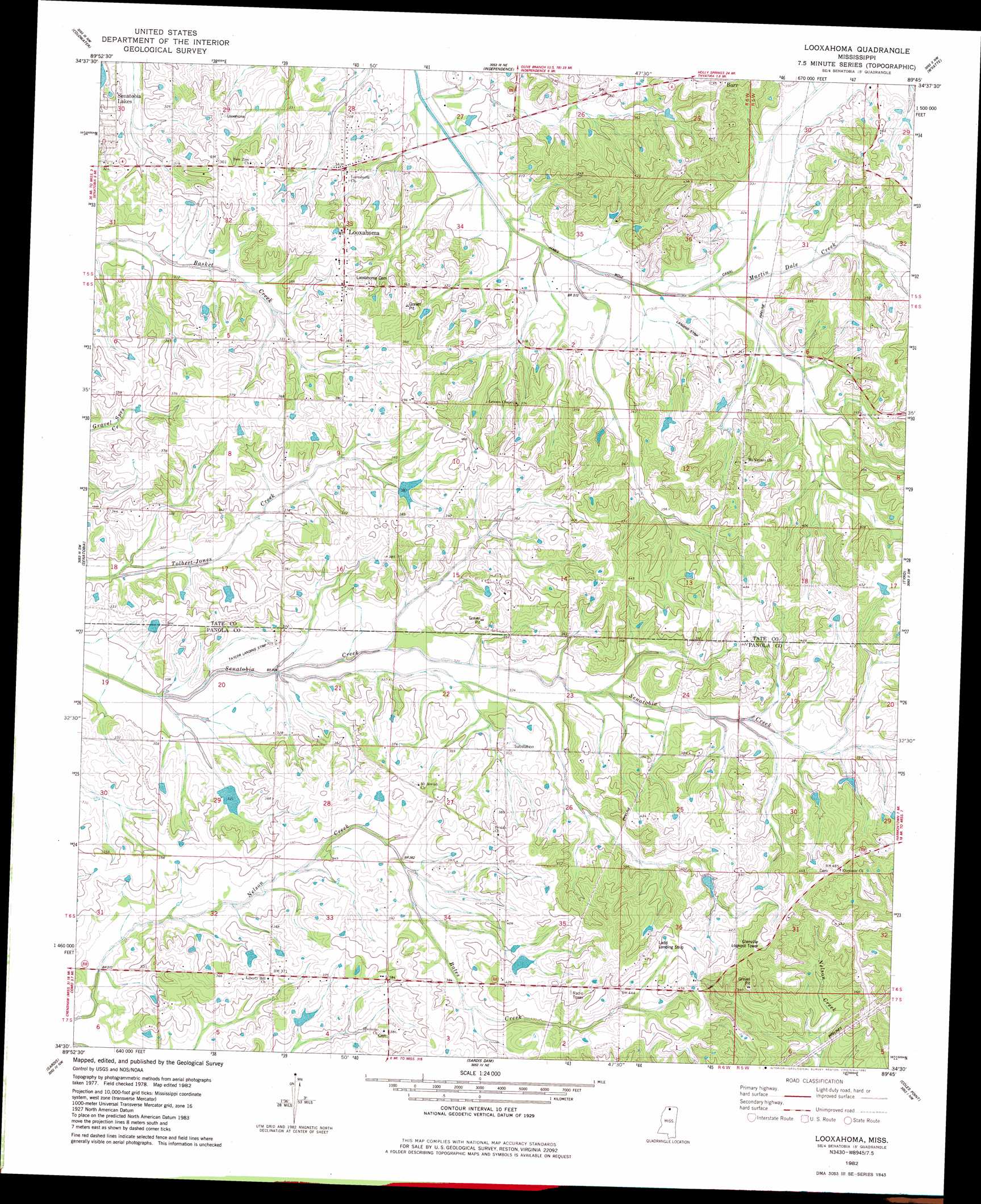
USGS Topo Quad 34089e7 - 1:24,000 scale
| Topo Map Name: | Looxahoma |
| USGS Topo Quad ID: | 34089e7 |
| Print Size: | ca. 21 1/4" wide x 27" high |
| Southeast Coordinates: | 34.5° N latitude / 89.75° W longitude |
| Map Center Coordinates: | 34.5625° N latitude / 89.8125° W longitude |
| U.S. State: | MS |
| Filename: | o34089e7.jpg |
| Download Map JPG Image: | Looxahoma topo map 1:24,000 scale |
| Map Type: | Topographic |
| Topo Series: | 7.5´ |
| Map Scale: | 1:24,000 |
| Source of Map Images: | United States Geological Survey (USGS) |
| Alternate Map Versions: |
Looxahoma MS 1982, updated 1982 Download PDF Buy paper map Looxahoma MS 2012 Download PDF Buy paper map Looxahoma MS 2015 Download PDF Buy paper map |
1:24,000 Topo Quads surrounding Looxahoma
Frees Corners |
Hernando |
Lewisburg |
Byhalia |
Red Banks |
Arkabutla East |
Coldwater |
Independence |
Wyatte |
Marianna |
Longtown |
Senatobia |
Looxahoma |
Tyro |
Laws Hill |
Pleasant Grove |
Sardis |
Sardis Dam |
Coles Point |
Oxford North |
Asa |
Batesville |
Sardis Se |
Splinter |
Oxford South |
> Back to 34089e1 at 1:100,000 scale
> Back to 34088a1 at 1:250,000 scale
> Back to U.S. Topo Maps home
Looxahoma topo map: Gazetteer
Looxahoma: Canals
James Wolf Canal elevation 92m 301′Looxahoma: Dams
A G Taylor Estate Pond Dam elevation 130m 426′Hickahala Creek Watershed C-34-9 Dam elevation 99m 324′
M P Moore Pond Dam elevation 104m 341′
Mrs Pauline Taylor Pond Dam elevation 111m 364′
Senatobia Creek Watershed Y-7-1 Dam elevation 106m 347′
Senatobia Creek Watershed Y-7-7 Dam elevation 117m 383′
Senatobia Creek Watershed Y-7-8 Dam elevation 104m 341′
W S Taylor Junior Pond Dam elevation 114m 374′
Looxahoma: Populated Places
Barr elevation 134m 439′Crossroad elevation 104m 341′
Looxahoma elevation 116m 380′
Looxahoma: Streams
Bates Creek elevation 106m 347′Martin Dale Creek elevation 95m 311′
Looxahoma digital topo map on disk
Buy this Looxahoma topo map showing relief, roads, GPS coordinates and other geographical features, as a high-resolution digital map file on DVD: