Potts Camp Topo Map Mississippi
To zoom in, hover over the map of Potts Camp
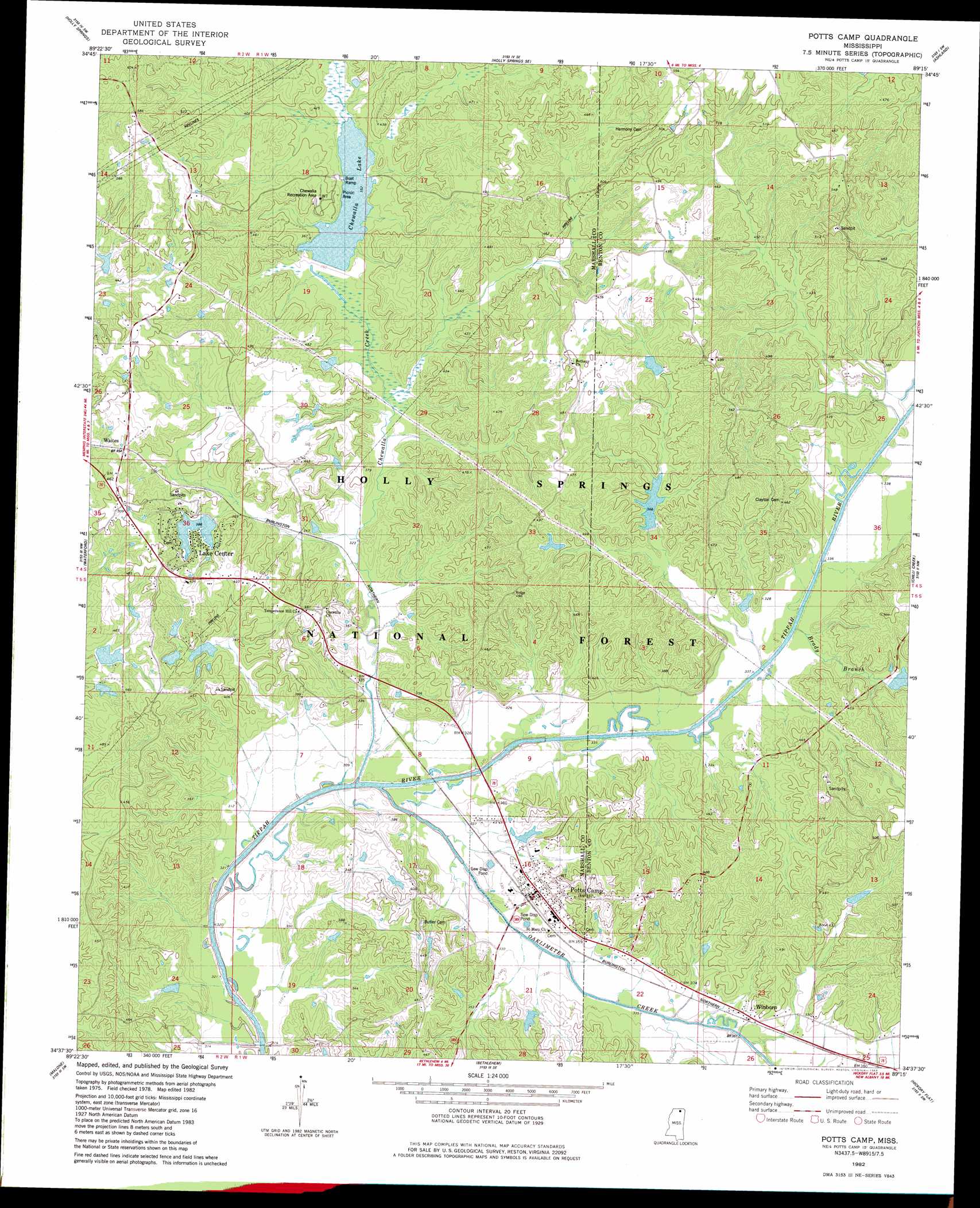
USGS Topo Quad 34089f3 - 1:24,000 scale
| Topo Map Name: | Potts Camp |
| USGS Topo Quad ID: | 34089f3 |
| Print Size: | ca. 21 1/4" wide x 27" high |
| Southeast Coordinates: | 34.625° N latitude / 89.25° W longitude |
| Map Center Coordinates: | 34.6875° N latitude / 89.3125° W longitude |
| U.S. State: | MS |
| Filename: | o34089f3.jpg |
| Download Map JPG Image: | Potts Camp topo map 1:24,000 scale |
| Map Type: | Topographic |
| Topo Series: | 7.5´ |
| Map Scale: | 1:24,000 |
| Source of Map Images: | United States Geological Survey (USGS) |
| Alternate Map Versions: |
Potts Camp MS 1982, updated 1983 Download PDF Buy paper map Potts Camp MS 2000, updated 2003 Download PDF Buy paper map Potts Camp MS 2012 Download PDF Buy paper map Potts Camp MS 2015 Download PDF Buy paper map |
| FStopo: | US Forest Service topo Potts Camp is available: Download FStopo PDF Download FStopo TIF |
1:24,000 Topo Quads surrounding Potts Camp
Mount Pleasant |
Slayden |
Lamar |
Canaan |
Camp Hill |
Red Banks |
Holly Springs |
Holly Springs Se |
Ashland |
Whitten Town |
Marianna |
Waterford |
Potts Camp |
Chilli Creek |
Blue Mountain |
Laws Hill |
Malone |
Bethlehem |
Hickory Flat |
Myrtle |
Oxford North |
Bagley Lake |
Puskus Lake |
Etta |
New Albany West |
> Back to 34089e1 at 1:100,000 scale
> Back to 34088a1 at 1:250,000 scale
> Back to U.S. Topo Maps home
Potts Camp topo map: Gazetteer
Potts Camp: Dams
Bond Lake Dam elevation 130m 426′Dickey Lake Dam elevation 99m 324′
Hudspeth Lake Dam elevation 150m 492′
Lake Center Dam elevation 128m 419′
LT 7-10 Dam elevation 110m 360′
Nichols Lake Dam elevation 115m 377′
Oaklimeter Watershed LT-8-35 Dam elevation 128m 419′
Thompson Lake Dam elevation 110m 360′
Tippah River Watershed LT-7-1 Dam elevation 105m 344′
White Lake Dam elevation 140m 459′
White Lake Dam elevation 134m 439′
Potts Camp: Parks
Chewalla Recreation Area elevation 126m 413′Potts Camp: Populated Places
Lake Center elevation 126m 413′Potts Camp elevation 105m 344′
Winborn elevation 112m 367′
Potts Camp: Reservoirs
Brady Lake elevation 110m 360′Chewalla Lake elevation 105m 344′
Cox Lake elevation 110m 360′
LT 7-10 Lake elevation 110m 360′
Potts Camp: Streams
Brady Branch elevation 98m 321′Chewalla Creek elevation 90m 295′
Oaklimeter Creek elevation 95m 311′
Potts Camp digital topo map on disk
Buy this Potts Camp topo map showing relief, roads, GPS coordinates and other geographical features, as a high-resolution digital map file on DVD: