Mellwood Topo Map Arkansas
To zoom in, hover over the map of Mellwood
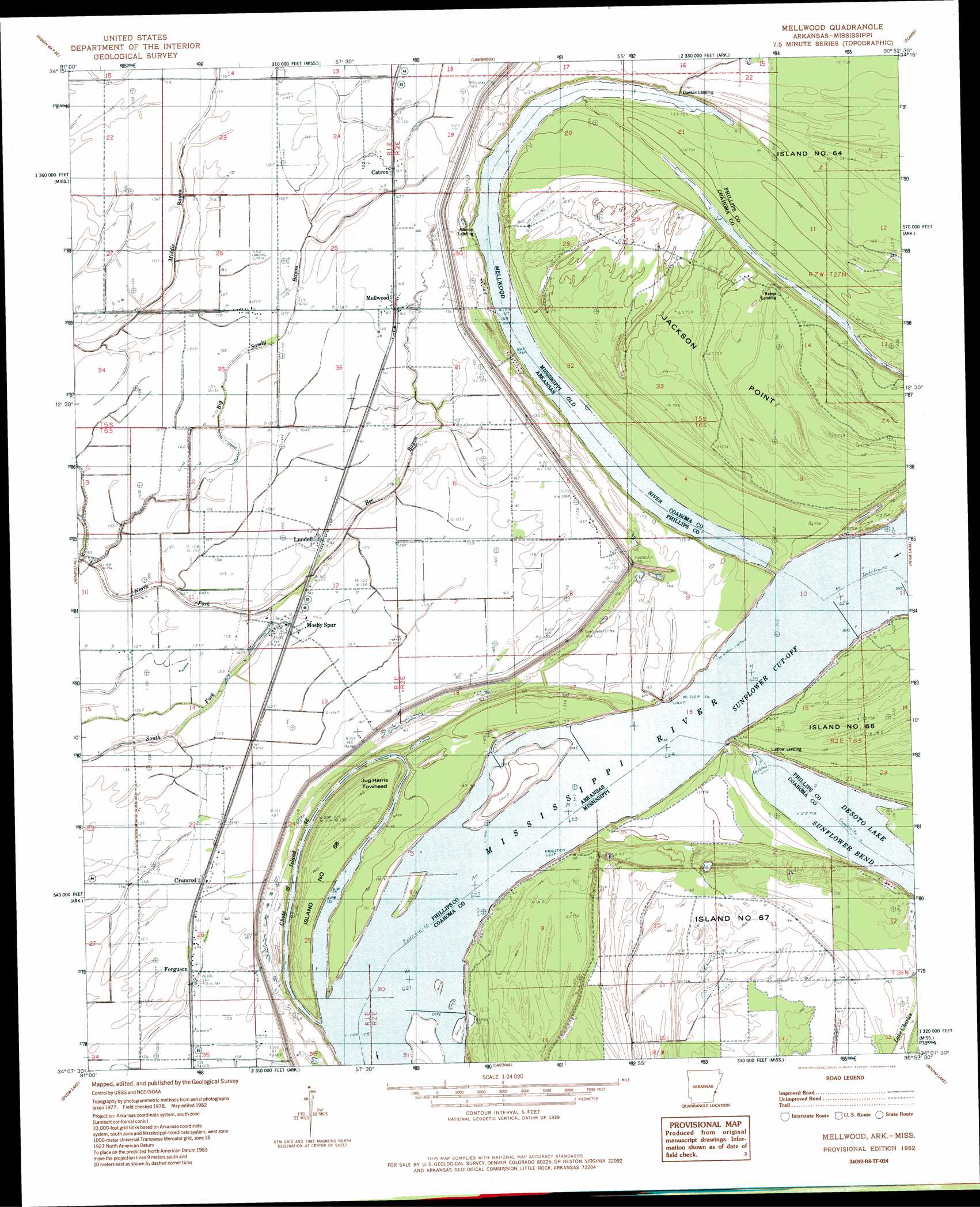
USGS Topo Quad 34090b8 - 1:24,000 scale
| Topo Map Name: | Mellwood |
| USGS Topo Quad ID: | 34090b8 |
| Print Size: | ca. 21 1/4" wide x 27" high |
| Southeast Coordinates: | 34.125° N latitude / 90.875° W longitude |
| Map Center Coordinates: | 34.1875° N latitude / 90.9375° W longitude |
| U.S. States: | AR, MS |
| Filename: | o34090b8.jpg |
| Download Map JPG Image: | Mellwood topo map 1:24,000 scale |
| Map Type: | Topographic |
| Topo Series: | 7.5´ |
| Map Scale: | 1:24,000 |
| Source of Map Images: | United States Geological Survey (USGS) |
| Alternate Map Versions: |
Mellwood AR 1982, updated 1982 Download PDF Buy paper map Mellwood AR 2011 Download PDF Buy paper map Mellwood AR 2014 Download PDF Buy paper map |
1:24,000 Topo Quads surrounding Mellwood
Crocketts Bluff |
Turner |
Watkins Corner |
Lakeview |
Friars Point Nw |
Ethel |
Indian Bay Se |
Lambrook |
Elaine |
Friars Point |
Weber |
Henrico Ne |
Mellwood |
Rena Lara |
Sherard |
Henrico Sw |
Snow Lake |
Laconia |
Round Lake |
Duncan |
Yancopin |
Montgomery Island |
Gunnison |
Shelby |
Mound Bayou |
> Back to 34090a1 at 1:100,000 scale
> Back to 34090a1 at 1:250,000 scale
> Back to U.S. Topo Maps home
Mellwood topo map: Gazetteer
Mellwood: Bends
Sunflower Cut-Off elevation 46m 150′Mellwood: Cliffs
Jackson Point elevation 53m 173′Mellwood: Guts
Chute of Island 68 elevation 46m 150′Mellwood: Islands
Island Number 68 elevation 49m 160′Island Number Sixtyfive elevation 51m 167′
Island Number Sixtyseven elevation 49m 160′
Jug Harris Towhead elevation 52m 170′
Mellwood: Lakes
Desoto Lake elevation 45m 147′Swan Lake elevation 47m 154′
Mellwood: Levees
Avenue Revetment elevation 45m 147′Below Ludlow Dikes elevation 46m 150′
Island Sixtyseven Revetment elevation 44m 144′
Lodlow Revetment elevation 46m 150′
Ludlow Revetment elevation 50m 164′
Mellwood: Populated Places
Catron elevation 51m 167′Crumrod elevation 50m 164′
Ferguson elevation 48m 157′
Ferguson Landing elevation 48m 157′
Lundell elevation 49m 160′
Mellwood elevation 49m 160′
Mosby Spur elevation 50m 164′
New Hope (historical) elevation 51m 167′
Offutt Landing elevation 46m 150′
Reese Landing elevation 43m 141′
Mellwood: Post Offices
Crumrad Post Office elevation 47m 154′Mellwood Post Office elevation 49m 160′
Mellwood: Streams
Bee Bayou elevation 48m 157′Big Sandy Bayou elevation 44m 144′
Mellwood: Swamps
Lake Charles elevation 47m 154′Mellwood digital topo map on disk
Buy this Mellwood topo map showing relief, roads, GPS coordinates and other geographical features, as a high-resolution digital map file on DVD: