Humphrey Sw Topo Map Arkansas
To zoom in, hover over the map of Humphrey Sw
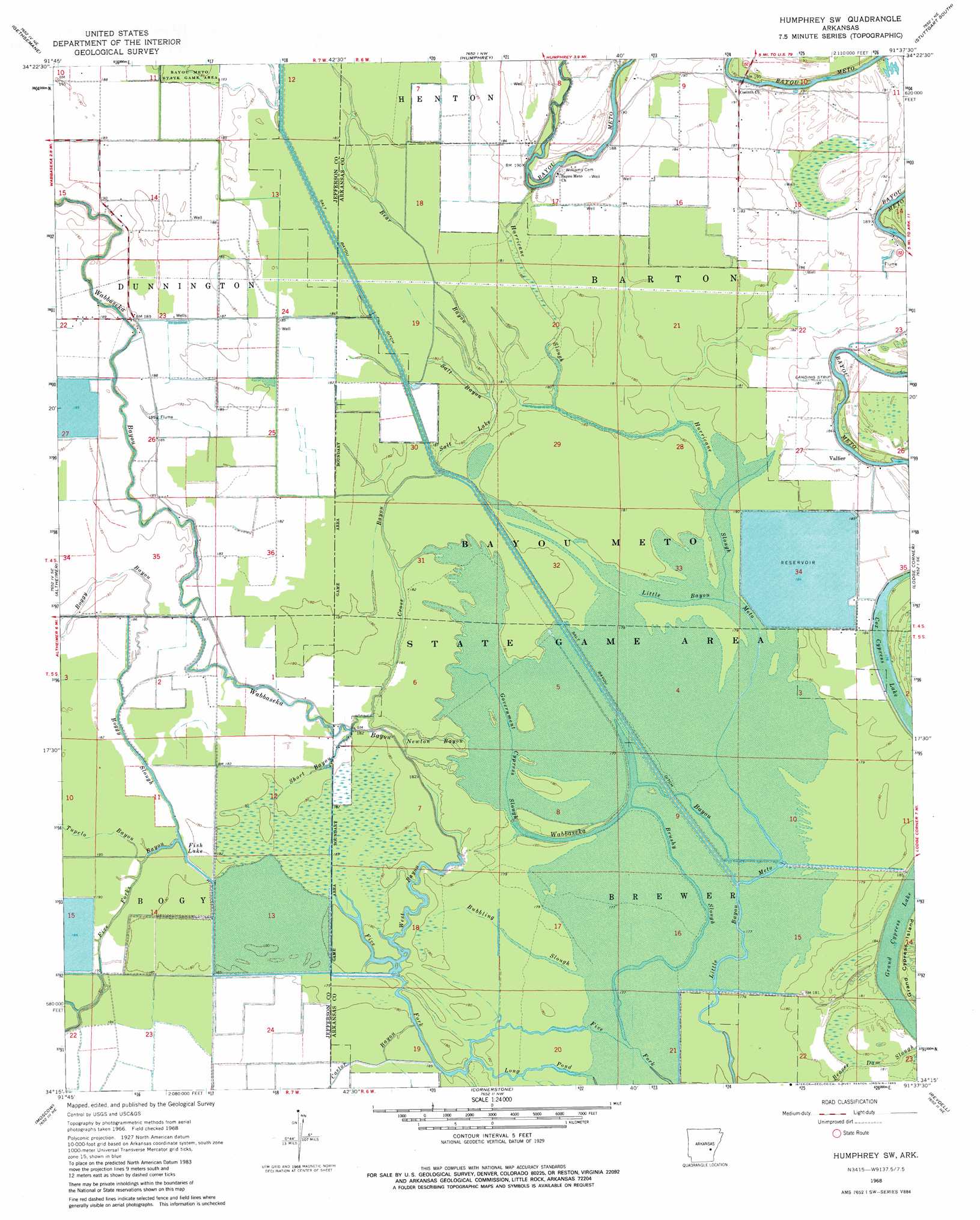
USGS Topo Quad 34091c6 - 1:24,000 scale
| Topo Map Name: | Humphrey Sw |
| USGS Topo Quad ID: | 34091c6 |
| Print Size: | ca. 21 1/4" wide x 27" high |
| Southeast Coordinates: | 34.25° N latitude / 91.625° W longitude |
| Map Center Coordinates: | 34.3125° N latitude / 91.6875° W longitude |
| U.S. State: | AR |
| Filename: | o34091c6.jpg |
| Download Map JPG Image: | Humphrey Sw topo map 1:24,000 scale |
| Map Type: | Topographic |
| Topo Series: | 7.5´ |
| Map Scale: | 1:24,000 |
| Source of Map Images: | United States Geological Survey (USGS) |
| Alternate Map Versions: |
Humphrey SW AR 1968, updated 1969 Download PDF Buy paper map Humphrey SW AR 1968, updated 1983 Download PDF Buy paper map Humphrey SW AR 1968, updated 1983 Download PDF Buy paper map Humphrey SW AR 2011 Download PDF Buy paper map Humphrey SW AR 2014 Download PDF Buy paper map |
1:24,000 Topo Quads surrounding Humphrey Sw
England |
Humnoke |
Geridge |
Stuttgart North |
Ulm |
Sherrill |
Gethsemane |
Humphrey |
Stuttgart South |
Almyra |
Rob Roy |
Altheimer |
Humphrey Sw |
Lodge Corner |
De Witt Sw |
Ladd |
Moscow |
Cornerstone |
Reydell |
One Horse Store |
Pinebergen |
Tarry |
Grady |
Cades |
Gillett |
> Back to 34091a1 at 1:100,000 scale
> Back to 34090a1 at 1:250,000 scale
> Back to U.S. Topo Maps home
Humphrey Sw topo map: Gazetteer
Humphrey Sw: Canals
Lateral Number 1 elevation 54m 177′Lateral Number 2 elevation 56m 183′
Lateral Number 2 elevation 58m 190′
Main Canal elevation 57m 187′
Humphrey Sw: Guts
Boggy Slough elevation 55m 180′Brushy Slough elevation 55m 180′
Cross Bayou elevation 58m 190′
Fish Lake elevation 54m 177′
Government Cypress Slough elevation 56m 183′
Hurricane Slough elevation 57m 187′
Newton Bayou elevation 56m 183′
Salt Bayou elevation 58m 190′
Salt Lake elevation 58m 190′
Short Bayou elevation 56m 183′
West Bayou elevation 55m 180′
Humphrey Sw: Lakes
Cox Cypress Lake elevation 55m 180′Humphrey Sw: Parks
Bayou Meto State Game Area elevation 57m 187′Humphrey Sw: Populated Places
Vallier elevation 59m 193′West Bayou (historical) elevation 57m 187′
Humphrey Sw: Reservoirs
Halowell Reservoir elevation 55m 180′Humphrey Sw: Streams
Bear Bayou elevation 59m 193′Boggy Bayou elevation 55m 180′
Bubbling Slough elevation 56m 183′
Castor Bayou elevation 57m 187′
Five Forks Bayou elevation 55m 180′
Tupelo Bayou elevation 56m 183′
Wabbaseka Bayou elevation 56m 183′
Humphrey Sw digital topo map on disk
Buy this Humphrey Sw topo map showing relief, roads, GPS coordinates and other geographical features, as a high-resolution digital map file on DVD: