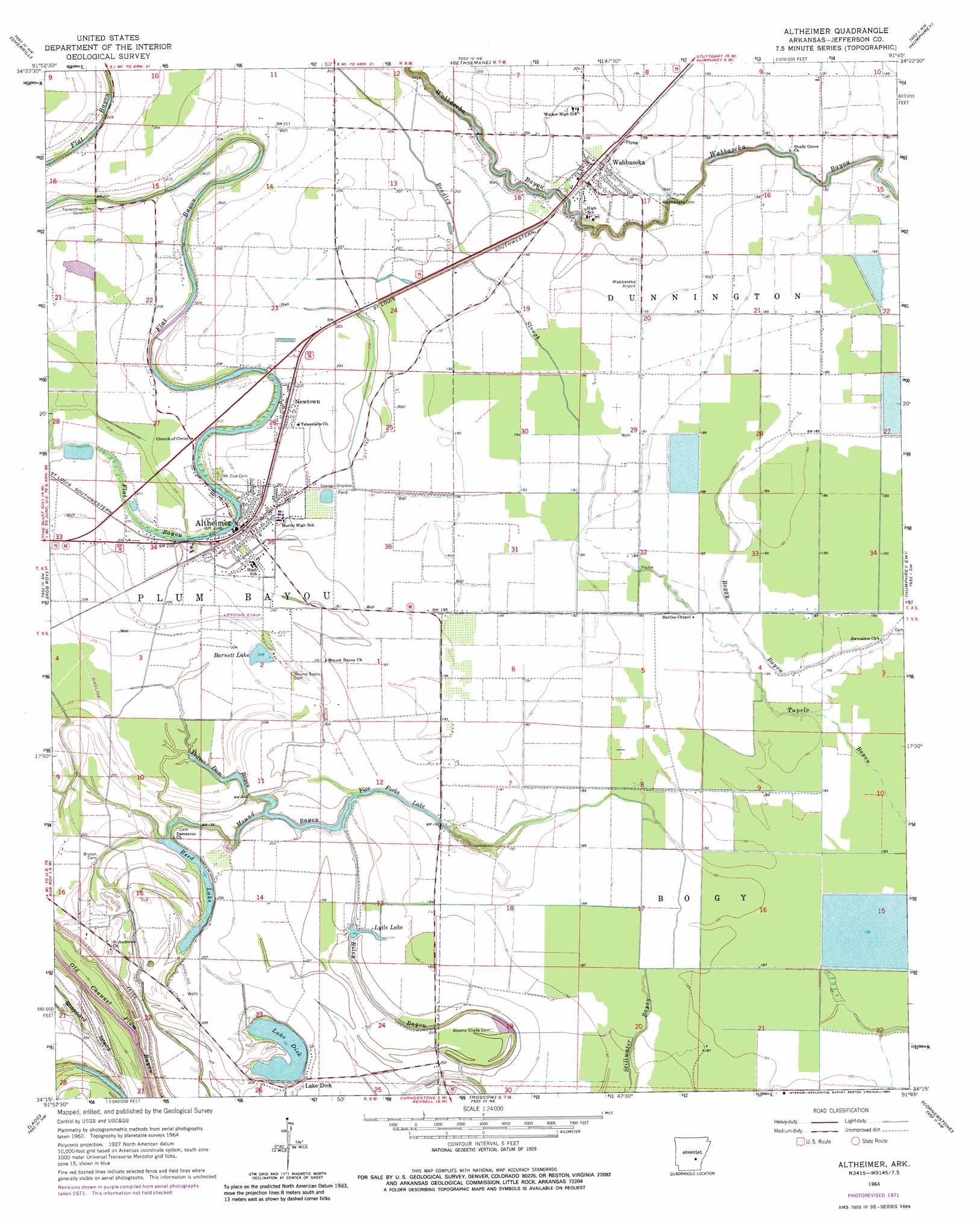
Altheimer Topo Map Arkansas
To zoom in, hover over the map of Altheimer
USGS Topo Quad 34091c7 - 1:24,000 scale
| Topo Map Name: | Altheimer |
| USGS Topo Quad ID: | 34091c7 |
| Print Size: | ca. 21 1/4" wide x 27" high |
| Southeast Coordinates: | 34.25° N latitude / 91.75° W longitude |
| Map Center Coordinates: | 34.3125° N latitude / 91.8125° W longitude |
| U.S. State: | AR |
| Filename: | o34091c7.jpg |
| Download Map JPG Image: | Altheimer topo map 1:24,000 scale |
| Map Type: | Topographic |
| Topo Series: | 7.5´ |
| Map Scale: | 1:24,000 |
| Source of Map Images: | United States Geological Survey (USGS) |
| Alternate Map Versions: |
Altheimer AR 1964, updated 1965 Download PDF Buy paper map Altheimer AR 1964, updated 1973 Download PDF Buy paper map Altheimer AR 1964, updated 1984 Download PDF Buy paper map Altheimer AR 2011 Download PDF Buy paper map Altheimer AR 2014 Download PDF Buy paper map |
1:24,000 Topo Quads surrounding Altheimer
Keo |
England |
Humnoke |
Geridge |
Stuttgart North |
Wright |
Sherrill |
Gethsemane |
Humphrey |
Stuttgart South |
White Hall |
Rob Roy |
Altheimer |
Humphrey Sw |
Lodge Corner |
Pine Bluff |
Ladd |
Moscow |
Cornerstone |
Reydell |
Faith |
Pinebergen |
Tarry |
Grady |
Cades |
> Back to 34091a1 at 1:100,000 scale
> Back to 34090a1 at 1:250,000 scale
> Back to U.S. Topo Maps home
Altheimer topo map: Gazetteer
Altheimer: Airports
Wabbaseka Flying Service Airport elevation 60m 196′Altheimer: Canals
Barraque Lateral elevation 59m 193′Lateral A-2 elevation 59m 193′
Lateral B elevation 58m 190′
Lateral Number 1 elevation 61m 200′
Lateral Number 2 elevation 61m 200′
Main Canal elevation 56m 183′
Altheimer: Guts
Bradley Slough elevation 59m 193′Mound Bayou elevation 59m 193′
Stillhouse Bayou elevation 58m 190′
Altheimer: Lakes
Barnett Lake elevation 64m 209′Five Forks Lake elevation 60m 196′
Lake Dick elevation 61m 200′
Reed Lake elevation 58m 190′
Altheimer: Populated Places
Altheimer elevation 65m 213′Lake Dick elevation 64m 209′
Newtown elevation 66m 216′
Wabbaseka elevation 61m 200′
Altheimer: Streams
Beaver Dam Bayou elevation 60m 196′King Bayou elevation 61m 200′
Riley Bayou elevation 59m 193′
Altheimer: Swamps
Tupelo Brake (historical) elevation 60m 196′Altheimer digital topo map on disk
Buy this Altheimer topo map showing relief, roads, GPS coordinates and other geographical features, as a high-resolution digital map file on DVD: