Hazen Topo Map Arkansas
To zoom in, hover over the map of Hazen
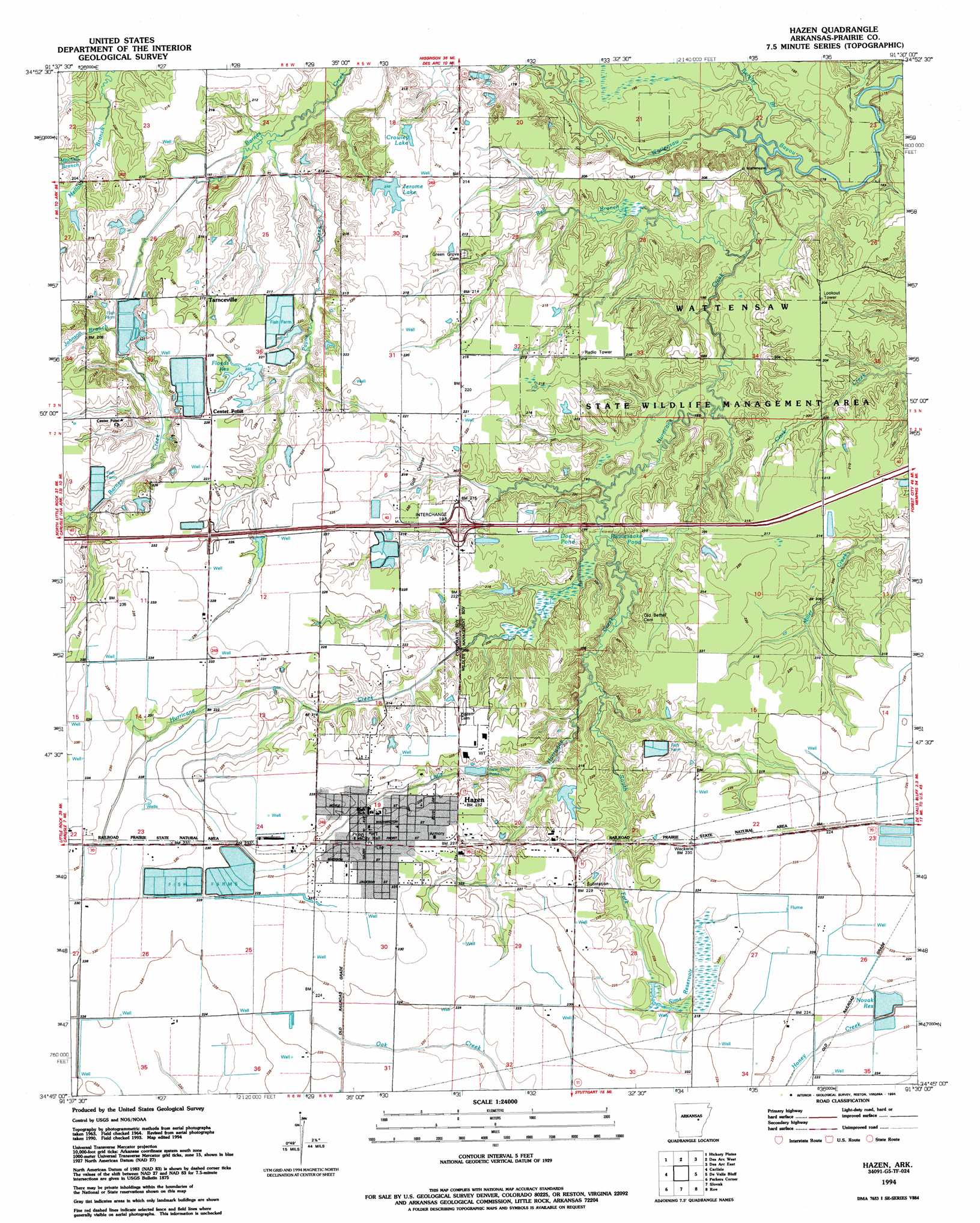
USGS Topo Quad 34091g5 - 1:24,000 scale
| Topo Map Name: | Hazen |
| USGS Topo Quad ID: | 34091g5 |
| Print Size: | ca. 21 1/4" wide x 27" high |
| Southeast Coordinates: | 34.75° N latitude / 91.5° W longitude |
| Map Center Coordinates: | 34.8125° N latitude / 91.5625° W longitude |
| U.S. State: | AR |
| Filename: | o34091g5.jpg |
| Download Map JPG Image: | Hazen topo map 1:24,000 scale |
| Map Type: | Topographic |
| Topo Series: | 7.5´ |
| Map Scale: | 1:24,000 |
| Source of Map Images: | United States Geological Survey (USGS) |
| Alternate Map Versions: |
Hazen AR 1964, updated 1965 Download PDF Buy paper map Hazen AR 1964, updated 1983 Download PDF Buy paper map Hazen AR 1964, updated 1986 Download PDF Buy paper map Hazen AR 1994, updated 1994 Download PDF Buy paper map Hazen AR 2011 Download PDF Buy paper map Hazen AR 2014 Download PDF Buy paper map |
1:24,000 Topo Quads surrounding Hazen
Mcrae |
Walker |
Jasmine |
Gregory Sw |
Cotton Plant |
Wattensaw |
Hickory Plains |
Des Arc West |
Des Arc East |
De Valls Bluff Ne |
Pocket Prarie |
Carlisle |
Hazen |
De Valls Bluff |
De Valls Bluff Se |
Culler |
Parkers Corner |
Slovak |
Roe |
Clarendon |
Humnoke |
Geridge |
Stuttgart North |
Ulm |
Aberdeen |
> Back to 34091e1 at 1:100,000 scale
> Back to 34090a1 at 1:250,000 scale
> Back to U.S. Topo Maps home
Hazen topo map: Gazetteer
Hazen: Airports
Fowlkes Field elevation 70m 229′Hazen Heliport elevation 71m 232′
Hazen: Crossings
Interchange 193 elevation 63m 206′Hazen: Dams
Arkansas Noname 127 Dam elevation 67m 219′Crowley Lake Dam elevation 64m 209′
Jerome Lake Dam elevation 65m 213′
Hazen: Parks
Wattensaw State Game Area elevation 60m 196′Hazen: Populated Places
Hazen elevation 71m 232′Tarnceville elevation 66m 216′
Thomas (historical) elevation 68m 223′
Hazen: Reservoirs
Crowley Lake elevation 64m 209′Floyds Reservoir elevation 67m 219′
Jerome Lake elevation 65m 213′
Novak Reservoir elevation 66m 216′
Sims Reservoir elevation 67m 219′
Hazen: Streams
Barkley Branch elevation 49m 160′Bell Branch elevation 54m 177′
Hurricane Creek elevation 50m 164′
Johnson Branch elevation 61m 200′
Little Hurricane Creek elevation 57m 187′
Mitchell Branch elevation 61m 200′
Payne Creek elevation 57m 187′
South Fork Little Hurricane Creek elevation 61m 200′
Hazen digital topo map on disk
Buy this Hazen topo map showing relief, roads, GPS coordinates and other geographical features, as a high-resolution digital map file on DVD: