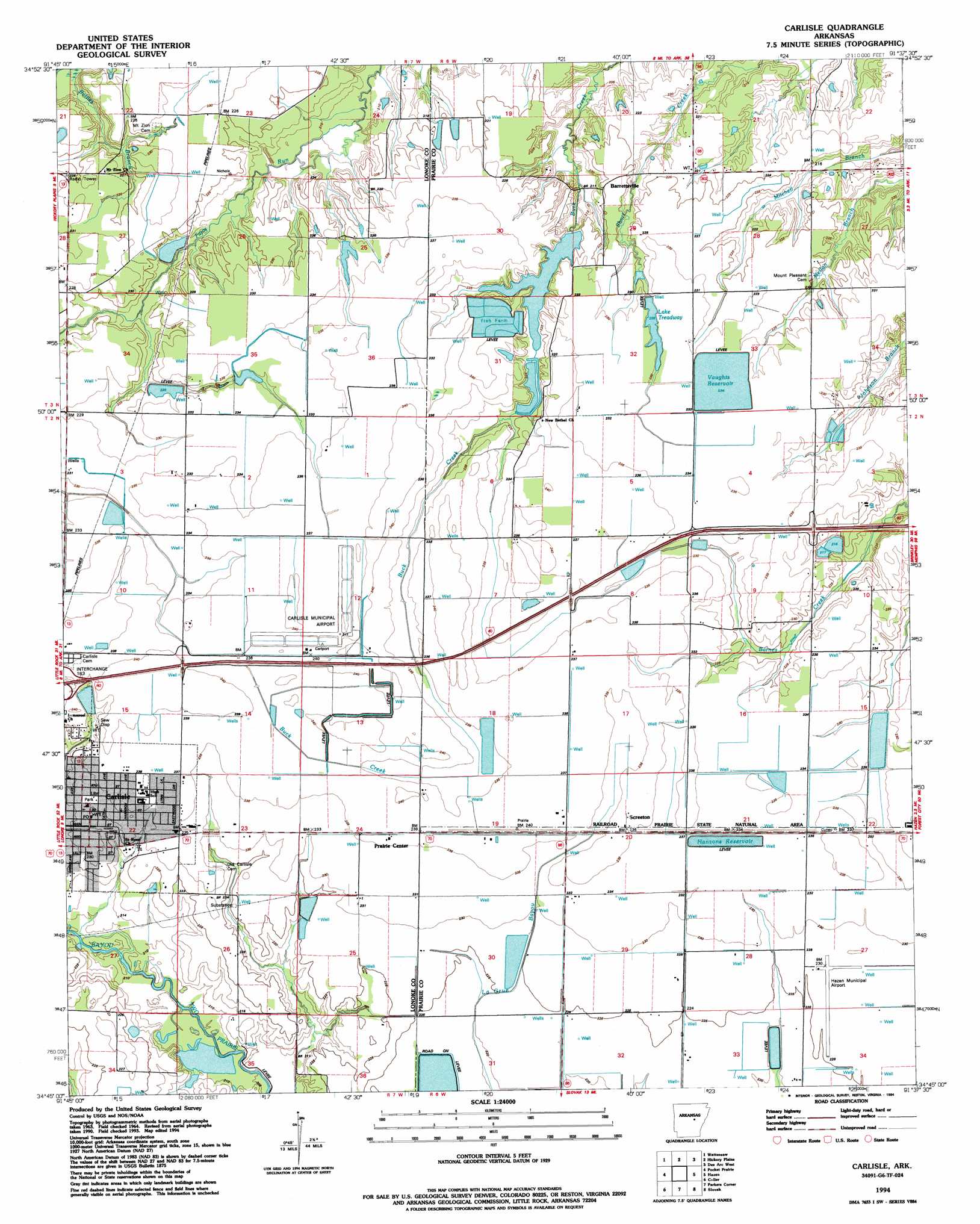
Carlisle Topo Map Arkansas
To zoom in, hover over the map of Carlisle
USGS Topo Quad 34091g6 - 1:24,000 scale
| Topo Map Name: | Carlisle |
| USGS Topo Quad ID: | 34091g6 |
| Print Size: | ca. 21 1/4" wide x 27" high |
| Southeast Coordinates: | 34.75° N latitude / 91.625° W longitude |
| Map Center Coordinates: | 34.8125° N latitude / 91.6875° W longitude |
| U.S. State: | AR |
| Filename: | o34091g6.jpg |
| Download Map JPG Image: | Carlisle topo map 1:24,000 scale |
| Map Type: | Topographic |
| Topo Series: | 7.5´ |
| Map Scale: | 1:24,000 |
| Source of Map Images: | United States Geological Survey (USGS) |
| Alternate Map Versions: |
Carlisle AR 1964, updated 1965 Download PDF Buy paper map Carlisle AR 1994, updated 1994 Download PDF Buy paper map Carlisle AR 2011 Download PDF Buy paper map Carlisle AR 2014 Download PDF Buy paper map |
1:24,000 Topo Quads surrounding Carlisle
Beebe |
Mcrae |
Walker |
Jasmine |
Gregory Sw |
Oak Grove |
Wattensaw |
Hickory Plains |
Des Arc West |
Des Arc East |
Lonoke |
Pocket Prarie |
Carlisle |
Hazen |
De Valls Bluff |
Pettus |
Culler |
Parkers Corner |
Slovak |
Roe |
England |
Humnoke |
Geridge |
Stuttgart North |
Ulm |
> Back to 34091e1 at 1:100,000 scale
> Back to 34090a1 at 1:250,000 scale
> Back to U.S. Topo Maps home
Carlisle topo map: Gazetteer
Carlisle: Airports
Carlisle Municipal Airport elevation 71m 232′Hazen Municipal Airport elevation 71m 232′
Carlisle: Dams
Lake Treadway Dam elevation 71m 232′Carlisle: Populated Places
Barrettsville elevation 70m 229′Carlisle elevation 71m 232′
Cuneo (historical) elevation 71m 232′
Prairie Center elevation 73m 239′
Screeton elevation 72m 236′
Carlisle: Reservoirs
Hansons Reservoir elevation 71m 232′Lake Treadway elevation 71m 232′
Vaughts Reservoir elevation 72m 236′
Carlisle: Streams
Battles Branch elevation 71m 232′Carlisle digital topo map on disk
Buy this Carlisle topo map showing relief, roads, GPS coordinates and other geographical features, as a high-resolution digital map file on DVD: