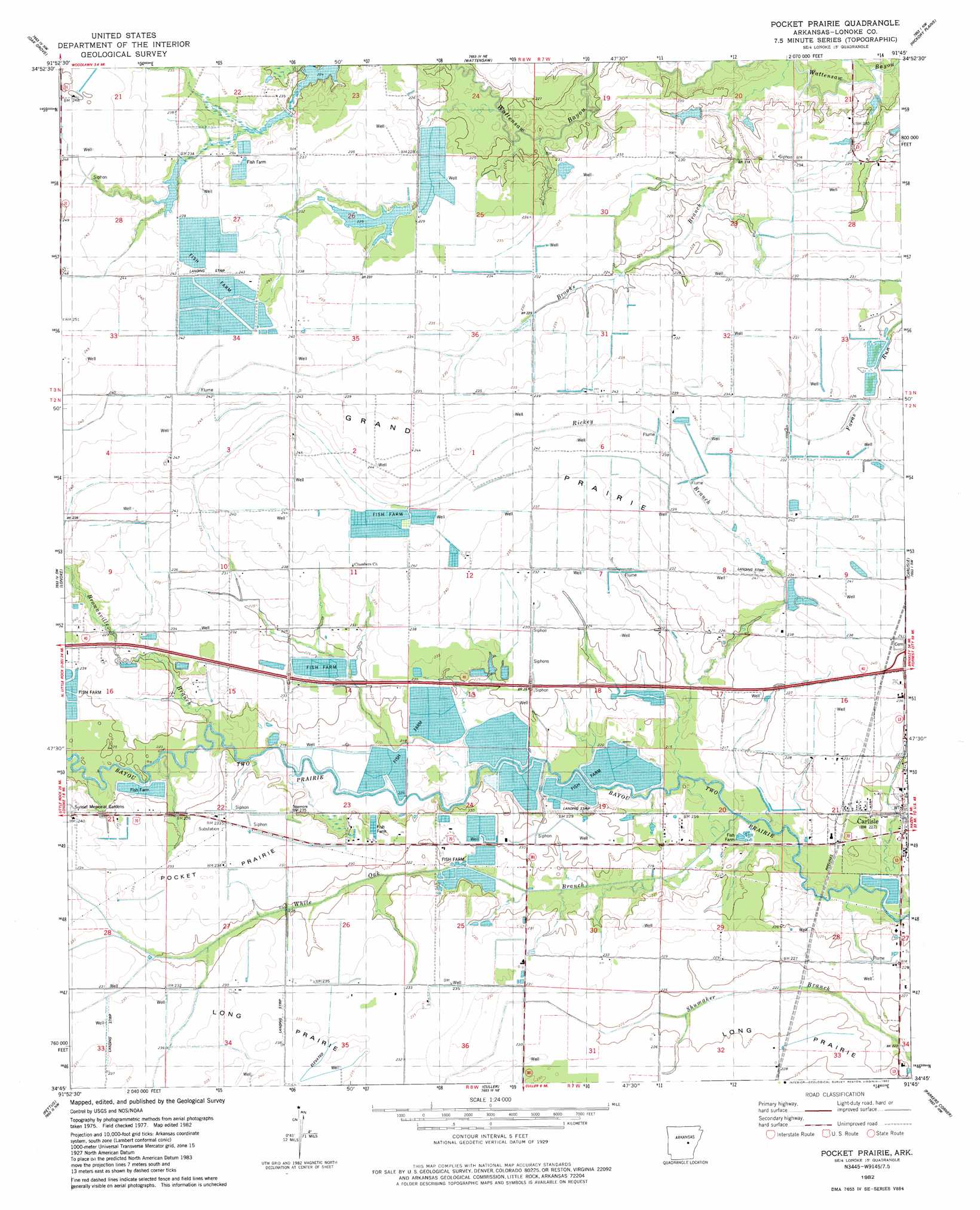
Pocket Prarie Topo Map Arkansas
To zoom in, hover over the map of Pocket Prarie
USGS Topo Quad 34091g7 - 1:24,000 scale
| Topo Map Name: | Pocket Prarie |
| USGS Topo Quad ID: | 34091g7 |
| Print Size: | ca. 21 1/4" wide x 27" high |
| Southeast Coordinates: | 34.75° N latitude / 91.75° W longitude |
| Map Center Coordinates: | 34.8125° N latitude / 91.8125° W longitude |
| U.S. State: | AR |
| Filename: | o34091g7.jpg |
| Download Map JPG Image: | Pocket Prarie topo map 1:24,000 scale |
| Map Type: | Topographic |
| Topo Series: | 7.5´ |
| Map Scale: | 1:24,000 |
| Source of Map Images: | United States Geological Survey (USGS) |
| Alternate Map Versions: |
Pocket Prairie AR 1982, updated 1982 Download PDF Buy paper map Pocket Prairie AR 2011 Download PDF Buy paper map Pocket Prairie AR 2014 Download PDF Buy paper map |
1:24,000 Topo Quads surrounding Pocket Prarie
Mountain Springs |
Beebe |
Mcrae |
Walker |
Jasmine |
Cabot |
Oak Grove |
Wattensaw |
Hickory Plains |
Des Arc West |
Jacksonville |
Lonoke |
Pocket Prarie |
Carlisle |
Hazen |
Scott |
Pettus |
Culler |
Parkers Corner |
Slovak |
Keo |
England |
Humnoke |
Geridge |
Stuttgart North |
> Back to 34091e1 at 1:100,000 scale
> Back to 34090a1 at 1:250,000 scale
> Back to U.S. Topo Maps home
Pocket Prarie topo map: Gazetteer
Pocket Prarie: Airports
Smiths Strip elevation 72m 236′Pocket Prarie: Crossings
Interchange 183 elevation 71m 232′Pocket Prarie: Dams
Sniders Pond Dam elevation 70m 229′Pocket Prarie: Flats
Pocket Prairie elevation 72m 236′Pocket Prarie: Populated Places
McCreanor elevation 70m 229′Sisemore elevation 72m 236′
Pocket Prarie: Reservoirs
Sniders Pond elevation 70m 229′Pocket Prarie: Streams
Brooks Branch elevation 66m 216′Brownsville Branch elevation 68m 223′
Rickey Branch elevation 65m 213′
White Oak Branch elevation 65m 213′
Pocket Prarie digital topo map on disk
Buy this Pocket Prarie topo map showing relief, roads, GPS coordinates and other geographical features, as a high-resolution digital map file on DVD: