Des Arc East Topo Map Arkansas
To zoom in, hover over the map of Des Arc East
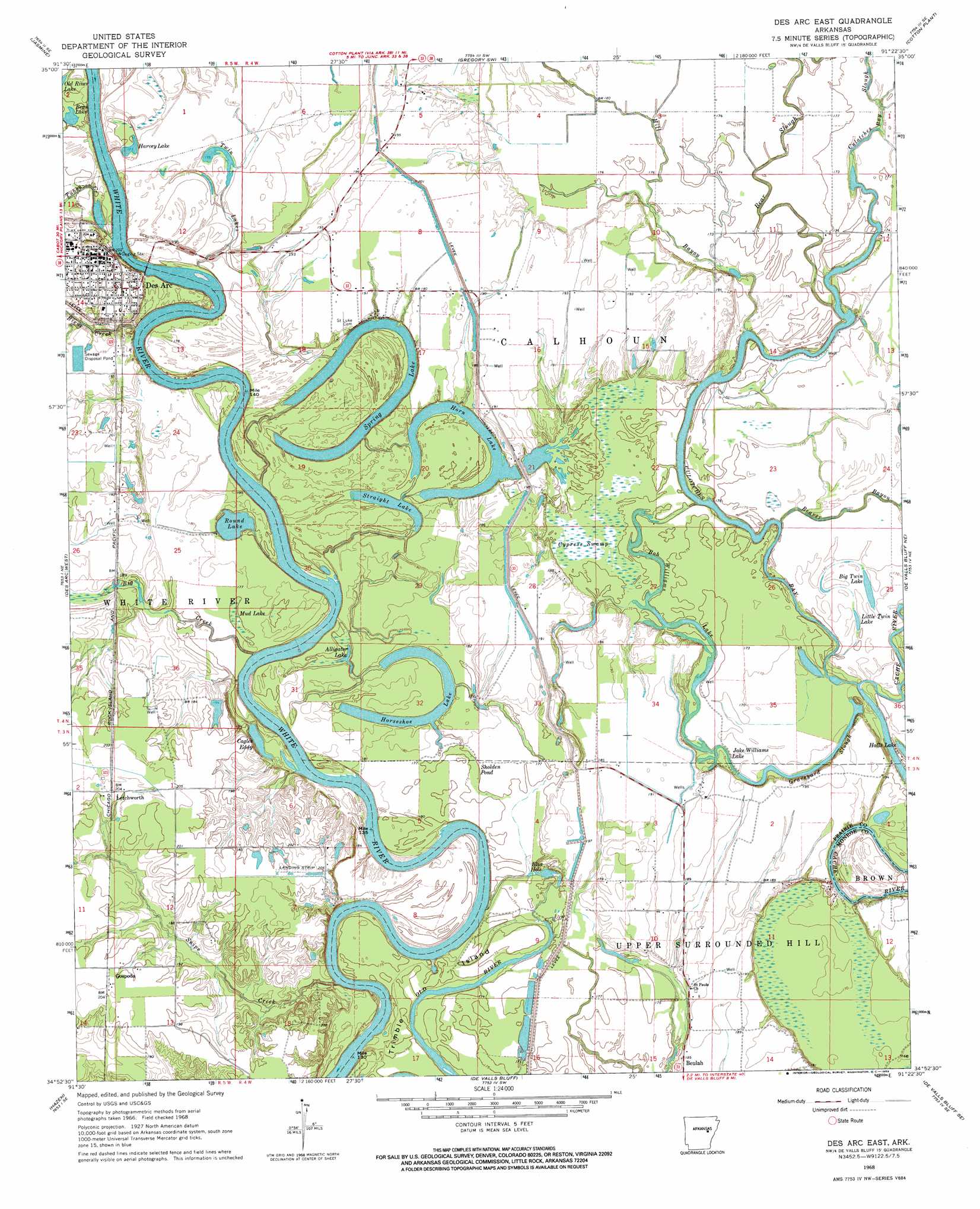
USGS Topo Quad 34091h4 - 1:24,000 scale
| Topo Map Name: | Des Arc East |
| USGS Topo Quad ID: | 34091h4 |
| Print Size: | ca. 21 1/4" wide x 27" high |
| Southeast Coordinates: | 34.875° N latitude / 91.375° W longitude |
| Map Center Coordinates: | 34.9375° N latitude / 91.4375° W longitude |
| U.S. State: | AR |
| Filename: | o34091h4.jpg |
| Download Map JPG Image: | Des Arc East topo map 1:24,000 scale |
| Map Type: | Topographic |
| Topo Series: | 7.5´ |
| Map Scale: | 1:24,000 |
| Source of Map Images: | United States Geological Survey (USGS) |
| Alternate Map Versions: |
Des Arc East AR 1968, updated 1969 Download PDF Buy paper map Des Arc East AR 2011 Download PDF Buy paper map Des Arc East AR 2014 Download PDF Buy paper map |
1:24,000 Topo Quads surrounding Des Arc East
Kensett |
West Point |
Georgetown |
Gregory |
Grays |
Walker |
Jasmine |
Gregory Sw |
Cotton Plant |
Hunter West |
Hickory Plains |
Des Arc West |
Des Arc East |
De Valls Bluff Ne |
Brinkley |
Carlisle |
Hazen |
De Valls Bluff |
De Valls Bluff Se |
Keevil |
Parkers Corner |
Slovak |
Roe |
Clarendon |
Park Grove |
> Back to 34091e1 at 1:100,000 scale
> Back to 34090a1 at 1:250,000 scale
> Back to U.S. Topo Maps home
Des Arc East topo map: Gazetteer
Des Arc East: Bends
Wilds Bend elevation 49m 160′Des Arc East: Dams
Eddy Lake Dam elevation 58m 190′Des Arc East: Guts
Bob Williams Lake elevation 53m 173′Graveyard Slough elevation 52m 170′
Jake Williams Lake elevation 52m 170′
Old River elevation 50m 164′
Des Arc East: Islands
Trimble Island elevation 54m 177′Des Arc East: Lakes
Alligator Lake elevation 52m 170′Bean Lake elevation 53m 173′
Big Twin Lake elevation 53m 173′
Blue Hole elevation 50m 164′
Cagles Eddy elevation 52m 170′
Harvey Lake elevation 51m 167′
Horn Lake elevation 51m 167′
Horseshoe Lake elevation 53m 173′
Little Twin Lake elevation 53m 173′
Round Lake elevation 54m 177′
Spring Lake elevation 52m 170′
Straight Lake elevation 53m 173′
Twin Lakes elevation 54m 177′
Des Arc East: Populated Places
Bay Plantation elevation 52m 170′Des Arc elevation 61m 200′
Erwin elevation 57m 187′
Gospoda elevation 60m 196′
Harrys (historical) elevation 59m 193′
Letchworth elevation 63m 206′
Plunketts elevation 59m 193′
Des Arc East: Reservoirs
Eddy Lake elevation 58m 190′Des Arc East: Streams
Bear Slough elevation 49m 160′Beaver Bayou elevation 51m 167′
Biene Creek elevation 49m 160′
Big Creek elevation 51m 167′
Culotches Bay Slough elevation 51m 167′
Hill Bayou elevation 50m 164′
Snipe Creek elevation 49m 160′
Tubbs Creek elevation 49m 160′
Des Arc East: Swamps
Cypress Swamp elevation 52m 170′Mud Lake elevation 55m 180′
Sholden Pond elevation 53m 173′
Des Arc East digital topo map on disk
Buy this Des Arc East topo map showing relief, roads, GPS coordinates and other geographical features, as a high-resolution digital map file on DVD: