Bunn Topo Map Arkansas
To zoom in, hover over the map of Bunn
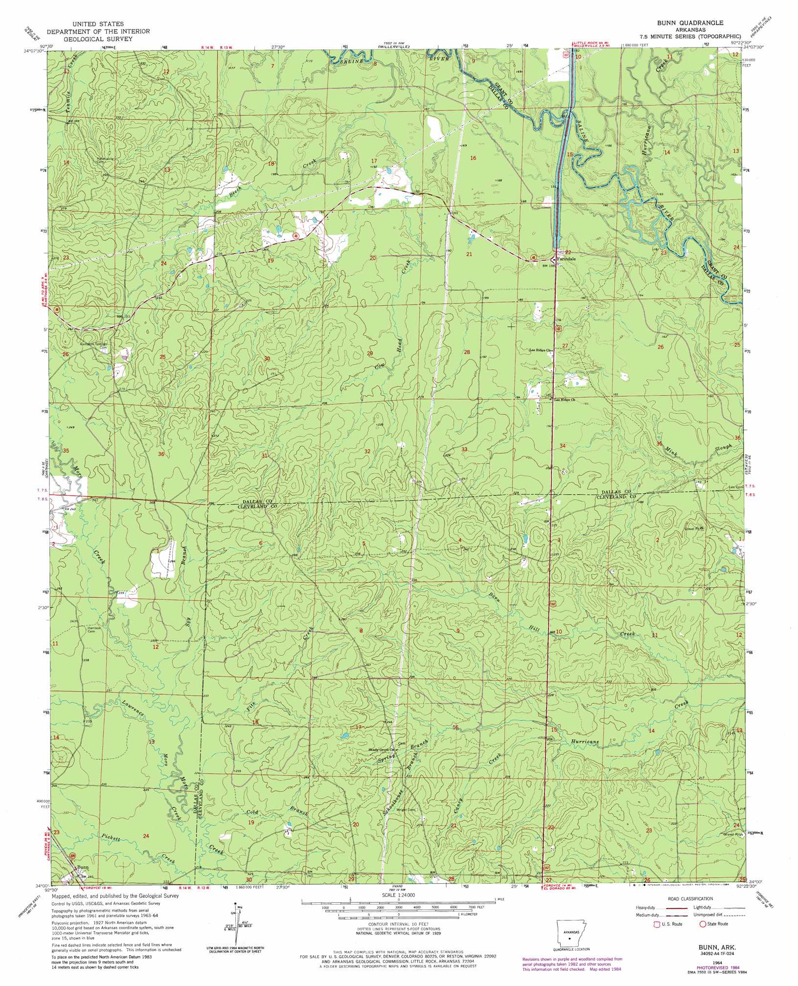
USGS Topo Quad 34092a4 - 1:24,000 scale
| Topo Map Name: | Bunn |
| USGS Topo Quad ID: | 34092a4 |
| Print Size: | ca. 21 1/4" wide x 27" high |
| Southeast Coordinates: | 34° N latitude / 92.375° W longitude |
| Map Center Coordinates: | 34.0625° N latitude / 92.4375° W longitude |
| U.S. State: | AR |
| Filename: | o34092a4.jpg |
| Download Map JPG Image: | Bunn topo map 1:24,000 scale |
| Map Type: | Topographic |
| Topo Series: | 7.5´ |
| Map Scale: | 1:24,000 |
| Source of Map Images: | United States Geological Survey (USGS) |
| Alternate Map Versions: |
Bunn AR 1964, updated 1965 Download PDF Buy paper map Bunn AR 1964, updated 1981 Download PDF Buy paper map Bunn AR 1964, updated 1984 Download PDF Buy paper map Bunn AR 2011 Download PDF Buy paper map Bunn AR 2014 Download PDF Buy paper map |
1:24,000 Topo Quads surrounding Bunn
Poyen |
Prattsville |
Sheridan |
Prague |
Hardin |
Willow |
Leola |
Millerville |
Grapevine |
Pine Bluff Nw |
Tulip |
Carthage |
Bunn |
Staves |
Kedron |
Princeton West |
Princeton East |
Ivan |
Fordyce Ne |
Rison |
Holly Springs |
Hopeville |
Fordyce |
Kingsland |
New Edinburg |
> Back to 34092a1 at 1:100,000 scale
> Back to 34092a1 at 1:250,000 scale
> Back to U.S. Topo Maps home
Bunn topo map: Gazetteer
Bunn: Crossings
Mornings Ferry (historical) elevation 49m 160′Bunn: Populated Places
Bleaker (historical) elevation 80m 262′Bunn elevation 76m 249′
Croak (historical) elevation 74m 242′
Farindale elevation 56m 183′
Mansville (historical) elevation 80m 262′
Saline (historical) elevation 70m 229′
Saline River (historical) elevation 54m 177′
Bunn: Streams
Beech Creek elevation 50m 164′Cane Creek elevation 55m 180′
Caney Creek elevation 61m 200′
Cold Branch elevation 70m 229′
Cow Head Creek elevation 53m 173′
Fite Creek elevation 71m 232′
Gamble Creek elevation 50m 164′
Hurricane Creek elevation 50m 164′
Schoolhouse Branch elevation 69m 226′
Spring Branch elevation 68m 223′
Spy Branch elevation 72m 236′
White Oak Creek elevation 53m 173′
Bunn digital topo map on disk
Buy this Bunn topo map showing relief, roads, GPS coordinates and other geographical features, as a high-resolution digital map file on DVD: