Wright Topo Map Arkansas
To zoom in, hover over the map of Wright
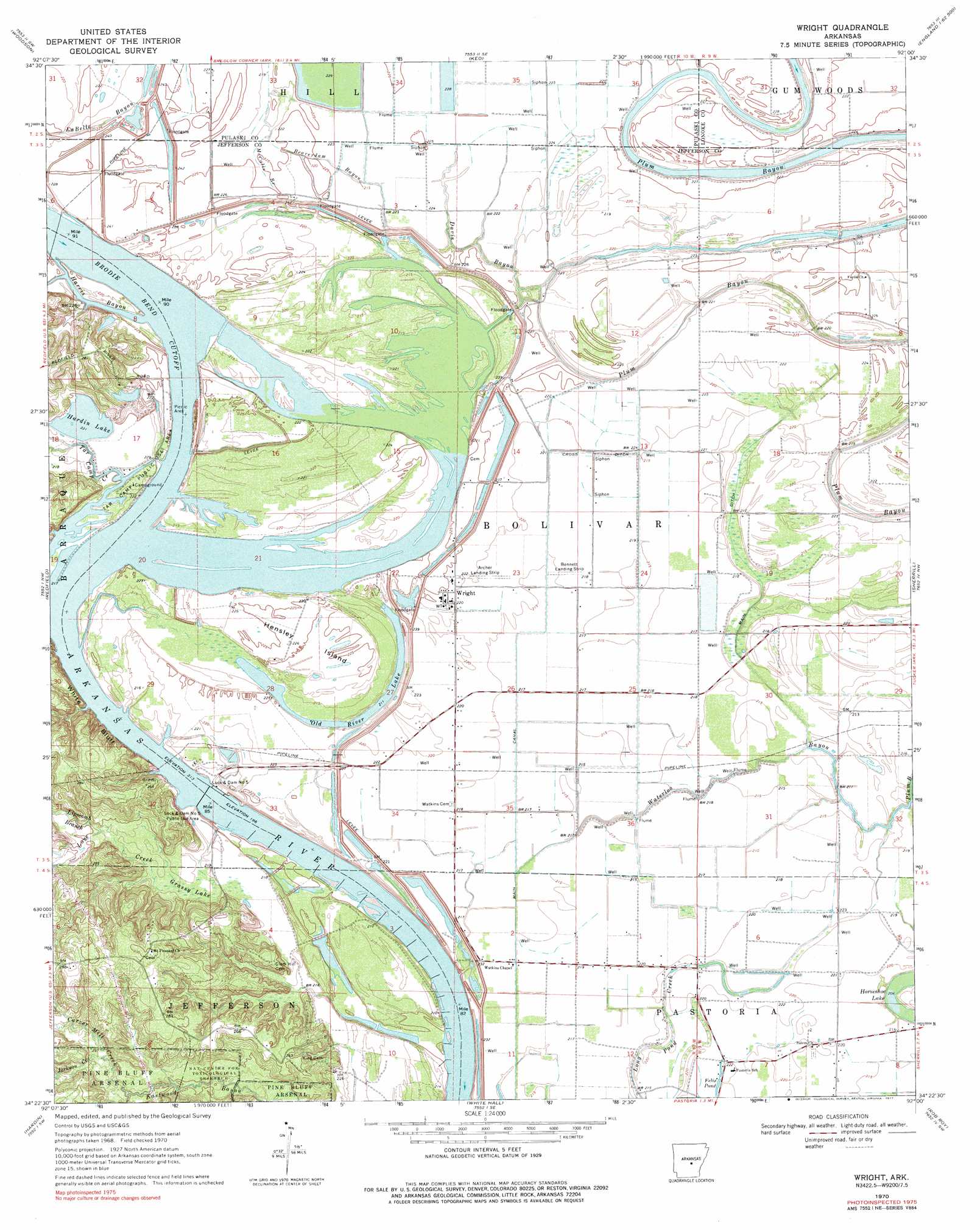
USGS Topo Quad 34092d1 - 1:24,000 scale
| Topo Map Name: | Wright |
| USGS Topo Quad ID: | 34092d1 |
| Print Size: | ca. 21 1/4" wide x 27" high |
| Southeast Coordinates: | 34.375° N latitude / 92° W longitude |
| Map Center Coordinates: | 34.4375° N latitude / 92.0625° W longitude |
| U.S. State: | AR |
| Filename: | o34092d1.jpg |
| Download Map JPG Image: | Wright topo map 1:24,000 scale |
| Map Type: | Topographic |
| Topo Series: | 7.5´ |
| Map Scale: | 1:24,000 |
| Source of Map Images: | United States Geological Survey (USGS) |
| Alternate Map Versions: |
Wright AR 1970, updated 1972 Download PDF Buy paper map Wright AR 1970, updated 1977 Download PDF Buy paper map Wright AR 2011 Download PDF Buy paper map Wright AR 2014 Download PDF Buy paper map |
1:24,000 Topo Quads surrounding Wright
Little Rock |
Sweet Home |
Scott |
Pettus |
Culler |
Spring Lake |
Woodson |
Keo |
England |
Humnoke |
Cane Creek |
Redfield |
Wright |
Sherrill |
Gethsemane |
Prague |
Hardin |
White Hall |
Rob Roy |
Altheimer |
Grapevine |
Pine Bluff Nw |
Pine Bluff |
Ladd |
Moscow |
> Back to 34092a1 at 1:100,000 scale
> Back to 34092a1 at 1:250,000 scale
> Back to U.S. Topo Maps home
Wright topo map: Gazetteer
Wright: Airports
Archer Landing Strip elevation 66m 216′Bennett Landing Strip elevation 66m 216′
Wright: Areas
Silers Island elevation 71m 232′Wright: Bars
Brodie Bar (historical) elevation 65m 213′Wright: Bends
Brodie Bend elevation 65m 213′Brodie Bend Cutoff elevation 65m 213′
Wright: Canals
Cross Ditch elevation 67m 219′Ditch A (historical) elevation 66m 216′
Ditch B elevation 66m 216′
Ditch C elevation 68m 223′
Ditch D elevation 66m 216′
Lateral F elevation 65m 213′
Lateral H elevation 65m 213′
Lateral I elevation 64m 209′
Lateral J elevation 66m 216′
Main Canal elevation 66m 216′
Main Ditch elevation 63m 206′
Wright: Capes
Mocks Point elevation 69m 226′Wright: Channels
Silers Chute (historical) elevation 70m 229′Tar Camp Crossing elevation 65m 213′
Wild Cat Crossing elevation 66m 216′
Wright: Cliffs
White Bluff elevation 68m 223′Wright: Crossings
Red Bluff Ferry (historical) elevation 65m 213′Wright: Dams
Bredlow Reservoir Dam elevation 66m 216′Dike Number One Dam elevation 73m 239′
Hardin Lake Dam elevation 68m 223′
Hardin Lake Dam Number Two elevation 70m 229′
Lock and Dam Number 5 elevation 64m 209′
Wright: Islands
Hensley Island elevation 68m 223′Wright: Lakes
Felix Pond elevation 66m 216′Horseshoe Lake elevation 64m 209′
Old River Lake elevation 63m 206′
Wright: Parks
Lock elevation 68m 223′Lock and Dam Number 5 Public Use Area elevation 68m 223′
Tar Camp Public Use Area elevation 67m 219′
Wright: Populated Places
Plum Bayou (historical) elevation 70m 229′Wright elevation 66m 216′
Wright: Post Offices
Plum Bayou Post Office (historical) elevation 66m 216′Wright: Reservoirs
Bredlow Reservoir elevation 66m 216′Clear Water Holding Pond elevation 73m 239′
Hardin Lake elevation 68m 223′
Hardin Lake Number Two elevation 70m 229′
Pool Five elevation 64m 209′
Wright: Streams
Beaverdam Bayou elevation 67m 219′Carver Mill Creek elevation 70m 229′
Davis Bayou elevation 68m 223′
Harris Bayou elevation 65m 213′
Jackson Creek elevation 76m 249′
Lipscomb Branch elevation 69m 226′
Love Creek elevation 65m 213′
McCalls Branch elevation 70m 229′
Tar Camp Creek elevation 65m 213′
Waterloo Bayou elevation 63m 206′
Wright: Swamps
Grassy Lake elevation 65m 213′Wright digital topo map on disk
Buy this Wright topo map showing relief, roads, GPS coordinates and other geographical features, as a high-resolution digital map file on DVD: