Redfield Topo Map Arkansas
To zoom in, hover over the map of Redfield
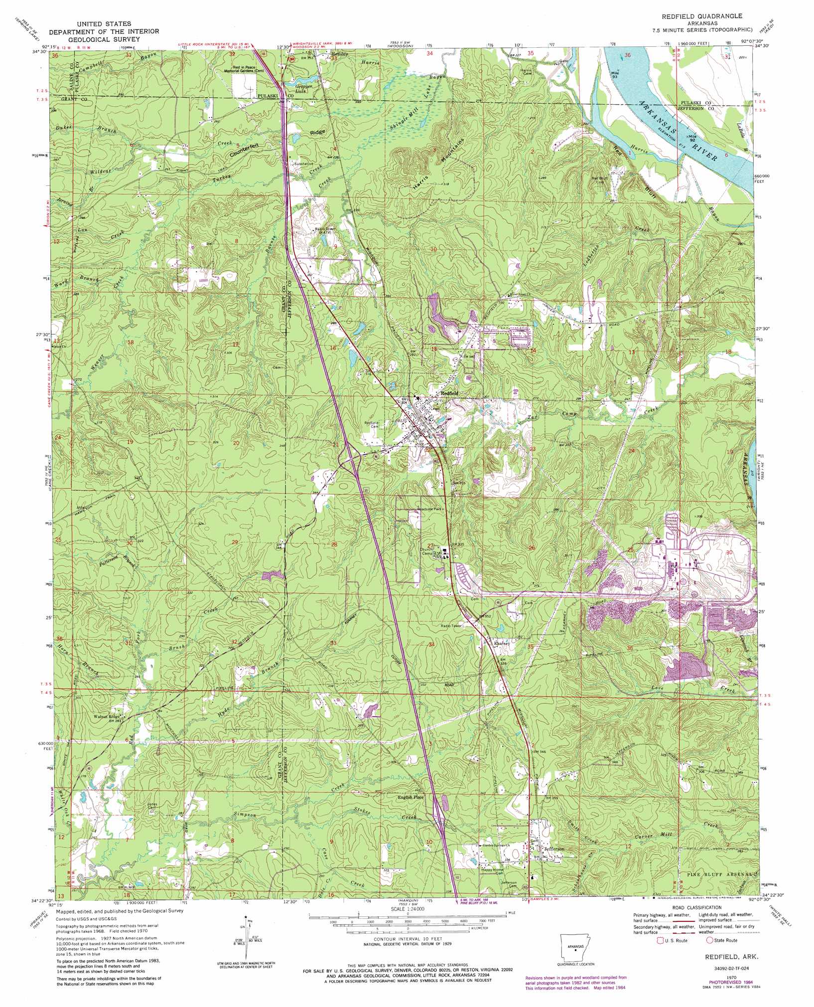
USGS Topo Quad 34092d2 - 1:24,000 scale
| Topo Map Name: | Redfield |
| USGS Topo Quad ID: | 34092d2 |
| Print Size: | ca. 21 1/4" wide x 27" high |
| Southeast Coordinates: | 34.375° N latitude / 92.125° W longitude |
| Map Center Coordinates: | 34.4375° N latitude / 92.1875° W longitude |
| U.S. State: | AR |
| Filename: | o34092d2.jpg |
| Download Map JPG Image: | Redfield topo map 1:24,000 scale |
| Map Type: | Topographic |
| Topo Series: | 7.5´ |
| Map Scale: | 1:24,000 |
| Source of Map Images: | United States Geological Survey (USGS) |
| Alternate Map Versions: |
Redfield AR 1970, updated 1972 Download PDF Buy paper map Redfield AR 1970, updated 1984 Download PDF Buy paper map Redfield AR 2011 Download PDF Buy paper map Redfield AR 2014 Download PDF Buy paper map |
1:24,000 Topo Quads surrounding Redfield
Alexander |
Little Rock |
Sweet Home |
Scott |
Pettus |
Bryant |
Spring Lake |
Woodson |
Keo |
England |
Belfast |
Cane Creek |
Redfield |
Wright |
Sherrill |
Sheridan |
Prague |
Hardin |
White Hall |
Rob Roy |
Millerville |
Grapevine |
Pine Bluff Nw |
Pine Bluff |
Ladd |
> Back to 34092a1 at 1:100,000 scale
> Back to 34092a1 at 1:250,000 scale
> Back to U.S. Topo Maps home
Redfield topo map: Gazetteer
Redfield: Cliffs
Red Bluff elevation 72m 236′Redfield: Dams
Dike Number Two Dam elevation 80m 262′Gropper Lake Dam elevation 74m 242′
Surge Pond Dam elevation 78m 255′
Redfield: Populated Places
Amber (historical) elevation 85m 278′English Place elevation 102m 334′
Jefferson elevation 105m 344′
Kearney elevation 109m 357′
Red Bluff (historical) elevation 86m 282′
Redfield elevation 92m 301′
Walnut Ridge elevation 84m 275′
Redfield: Reservoirs
Clean Water Holding Pond elevation 80m 262′Gropper Lake elevation 74m 242′
Surge Pond elevation 78m 255′
Redfield: Ridges
Counterfeit Ridge elevation 76m 249′Redfield: Streams
Barnes Creek elevation 69m 226′Bradley Branch elevation 82m 269′
Brush Creek elevation 90m 295′
Case Creek elevation 83m 272′
Dale Creek elevation 89m 291′
Dukes Branch elevation 78m 255′
Horn Branch elevation 83m 272′
Hyde Branch elevation 81m 265′
Jerning Branch elevation 87m 285′
Ledbetter Creek elevation 69m 226′
Lou Creek elevation 85m 278′
Patterson Branch elevation 93m 305′
Red Fork elevation 76m 249′
Rinehart Creek elevation 69m 226′
Schoolhouse Creek elevation 90m 295′
Smith Creek elevation 89m 291′
Stokes Creek elevation 84m 275′
Turkey Creek elevation 78m 255′
Ward Branch elevation 79m 259′
Weaver Creek elevation 88m 288′
Wildcat Creek elevation 66m 216′
Redfield: Summits
Harris Mountains elevation 98m 321′Redfield: Swamps
Shingle Mill Lake elevation 71m 232′Redfield digital topo map on disk
Buy this Redfield topo map showing relief, roads, GPS coordinates and other geographical features, as a high-resolution digital map file on DVD: