Congo Topo Map Arkansas
To zoom in, hover over the map of Congo
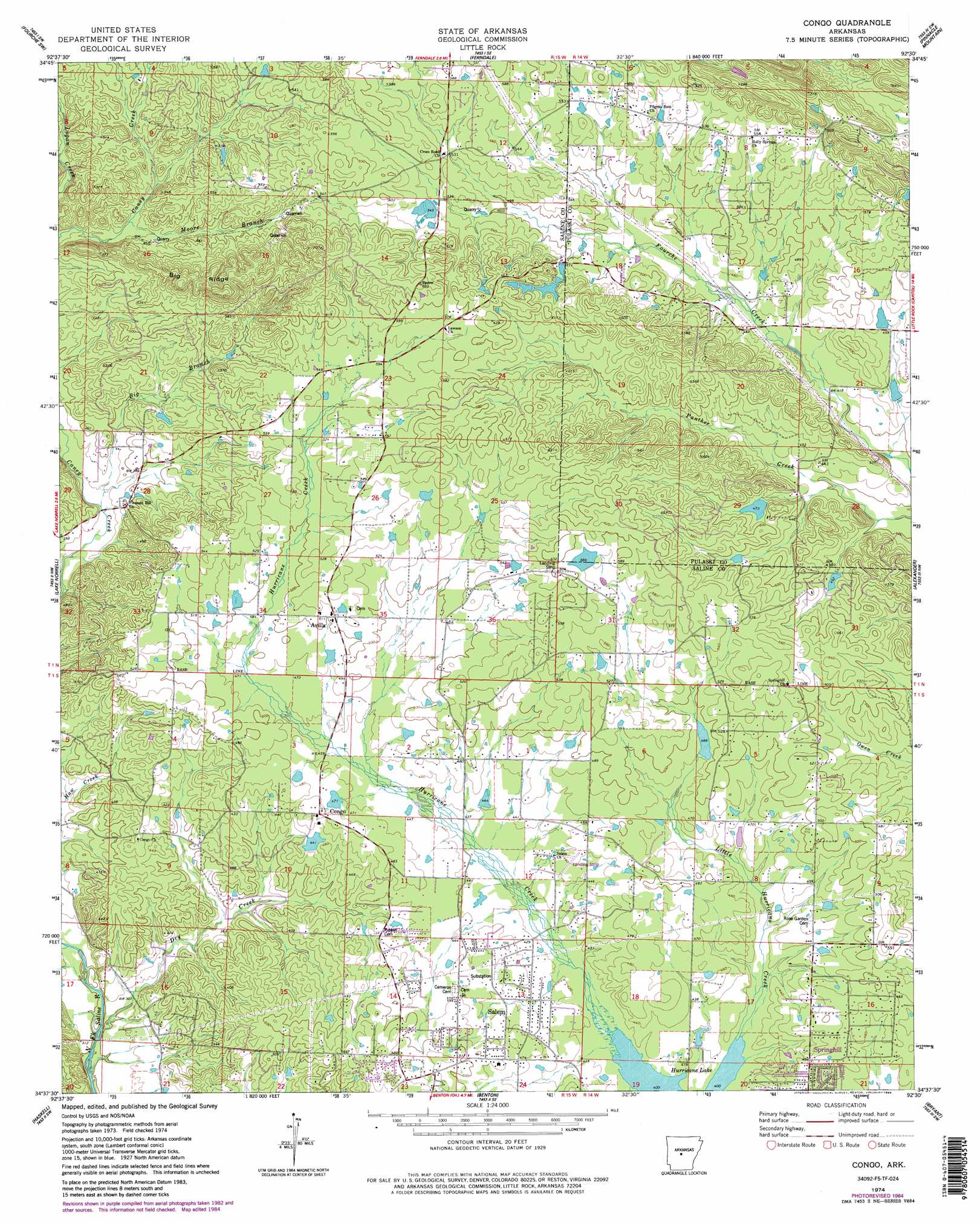
USGS Topo Quad 34092f5 - 1:24,000 scale
| Topo Map Name: | Congo |
| USGS Topo Quad ID: | 34092f5 |
| Print Size: | ca. 21 1/4" wide x 27" high |
| Southeast Coordinates: | 34.625° N latitude / 92.5° W longitude |
| Map Center Coordinates: | 34.6875° N latitude / 92.5625° W longitude |
| U.S. State: | AR |
| Filename: | o34092f5.jpg |
| Download Map JPG Image: | Congo topo map 1:24,000 scale |
| Map Type: | Topographic |
| Topo Series: | 7.5´ |
| Map Scale: | 1:24,000 |
| Source of Map Images: | United States Geological Survey (USGS) |
| Alternate Map Versions: |
Congo AR 1974, updated 1977 Download PDF Buy paper map Congo AR 1974, updated 1984 Download PDF Buy paper map Congo AR 1974, updated 1984 Download PDF Buy paper map Congo AR 1994, updated 2000 Download PDF Buy paper map Congo AR 2011 Download PDF Buy paper map Congo AR 2014 Download PDF Buy paper map |
1:24,000 Topo Quads surrounding Congo
Thornburg |
Martindale |
Fourche |
Mayflower |
Cato |
Paron |
Fourche Sw |
Ferndale |
Pinnacle Mountain |
North Little Rock |
Lonsdale Ne |
Lake Norrell |
Congo |
Alexander |
Little Rock |
Lonsdale |
Haskell |
Benton |
Bryant |
Spring Lake |
Malvern North |
Traskwood |
Tull |
Belfast |
Cane Creek |
> Back to 34092e1 at 1:100,000 scale
> Back to 34092a1 at 1:250,000 scale
> Back to U.S. Topo Maps home
Congo topo map: Gazetteer
Congo: Airports
Stephens Heliport elevation 166m 544′Congo: Dams
4-H Camp Lake Dam elevation 133m 436′Congo Lake Dam elevation 133m 436′
Crystal Lake Dam elevation 140m 459′
Fletcher Lake Dam elevation 174m 570′
Glover Lake Dam elevation 140m 459′
Helmich Lake Dam elevation 145m 475′
Hester Lake Dam elevation 148m 485′
Inman Lake Number Two Dam elevation 167m 547′
Pine Crest Lake Dam elevation 141m 462′
Congo: Populated Places
Avilla elevation 155m 508′Congo elevation 147m 482′
Holly Springs elevation 174m 570′
Salem elevation 144m 472′
Springhill elevation 144m 472′
Tatumville (historical) elevation 169m 554′
Congo: Reservoirs
4-H Camp Lake elevation 133m 436′Crystal Lake elevation 140m 459′
Fletcher Lake elevation 174m 570′
Glover Lake elevation 140m 459′
Helmich Lake elevation 145m 475′
Hester Lake elevation 148m 485′
Inman Lake Number Two elevation 167m 547′
Maertins Lake elevation 133m 436′
Pine Crest Lake elevation 141m 462′
Congo: Ridges
Big Ridge elevation 192m 629′Congo: Streams
Beauchamp Branch elevation 120m 393′Big Branch elevation 110m 360′
Dry Creek elevation 91m 298′
Hamma Branch elevation 138m 452′
Little Hurricane Creek elevation 122m 400′
Moore Branch elevation 151m 495′
Congo digital topo map on disk
Buy this Congo topo map showing relief, roads, GPS coordinates and other geographical features, as a high-resolution digital map file on DVD: