Murfreesboro Topo Map Arkansas
To zoom in, hover over the map of Murfreesboro
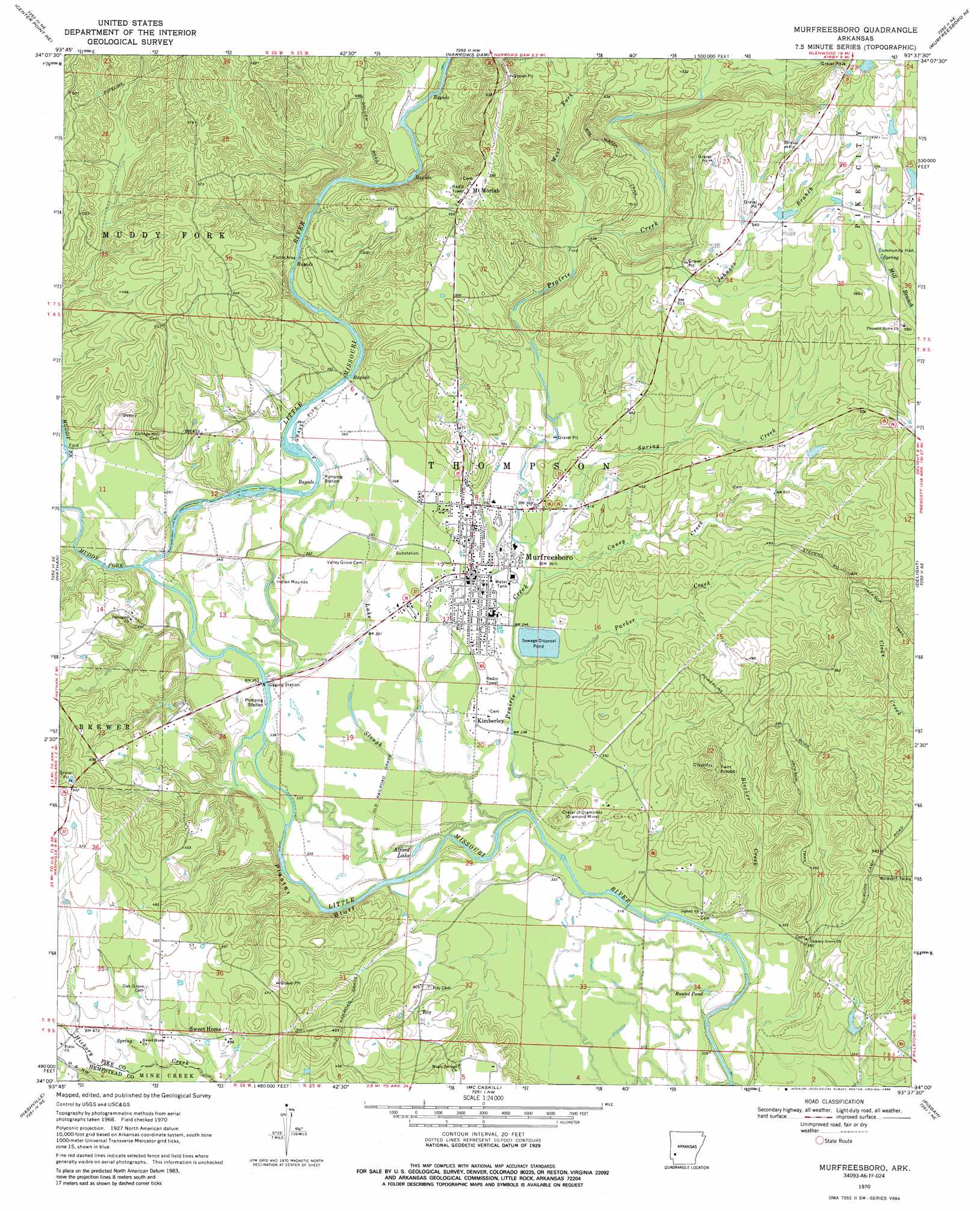
USGS Topo Quad 34093a6 - 1:24,000 scale
| Topo Map Name: | Murfreesboro |
| USGS Topo Quad ID: | 34093a6 |
| Print Size: | ca. 21 1/4" wide x 27" high |
| Southeast Coordinates: | 34° N latitude / 93.625° W longitude |
| Map Center Coordinates: | 34.0625° N latitude / 93.6875° W longitude |
| U.S. State: | AR |
| Filename: | o34093a6.jpg |
| Download Map JPG Image: | Murfreesboro topo map 1:24,000 scale |
| Map Type: | Topographic |
| Topo Series: | 7.5´ |
| Map Scale: | 1:24,000 |
| Source of Map Images: | United States Geological Survey (USGS) |
| Alternate Map Versions: |
Murfreesboro AR 1970, updated 1972 Download PDF Buy paper map Murfreesboro AR 1970, updated 1986 Download PDF Buy paper map Murfreesboro AR 1980, updated 1982 Download PDF Buy paper map Murfreesboro AR 2011 Download PDF Buy paper map Murfreesboro AR 2014 Download PDF Buy paper map |
1:24,000 Topo Quads surrounding Murfreesboro
Athens |
Langley |
Lodi |
Glenwood |
Amity |
Newhope |
Center Point Ne |
Narrows Dam |
Murfreesboro Ne |
Chalybeate Mountain West |
Center Point |
Nathan |
Murfreesboro |
Delight |
Antoine |
Mineral Springs North |
Nashville |
Mccaskill |
Pisgah |
Piney Grove |
Mineral Springs South |
Columbus |
Washington |
Blevins |
Prescott West |
> Back to 34093a1 at 1:100,000 scale
> Back to 34092a1 at 1:250,000 scale
> Back to U.S. Topo Maps home
Murfreesboro topo map: Gazetteer
Murfreesboro: Airports
Pike County Hospital Heliport elevation 108m 354′Murfreesboro: Cliffs
Plaster Bluff elevation 117m 383′Murfreesboro: Dams
Womack Lake Dam elevation 175m 574′Murfreesboro: Lakes
Alford Lake elevation 99m 324′Round Pond elevation 97m 318′
Murfreesboro: Mines
American Mine elevation 180m 590′Arkansas Mine elevation 108m 354′
Crater of Diamonds elevation 107m 351′
Kimberlite Mine elevation 161m 528′
Mauney Mine elevation 109m 357′
Ozark Mine elevation 113m 370′
Murfreesboro: Parks
Crater of Diamonds State Park elevation 115m 377′Murfreesboro: Populated Places
Arp (historical) elevation 175m 574′Ball (historical) elevation 137m 449′
Kimberley elevation 106m 347′
Maxwell (historical) elevation 117m 383′
Mount Moriah elevation 180m 590′
Murfreesboro elevation 113m 370′
Pleasant Home (historical) elevation 173m 567′
Roy elevation 130m 426′
Stephenson (historical) elevation 140m 459′
Murfreesboro: Reservoirs
Womack Lake elevation 175m 574′Murfreesboro: Streams
Blocker Creek elevation 97m 318′Caney Creek elevation 107m 351′
Johnson Branch elevation 134m 439′
Lake Slough elevation 98m 321′
Muddy Fork elevation 102m 334′
Parker Creek elevation 105m 344′
Poorhouse Branch elevation 97m 318′
Prairie Creek elevation 97m 318′
Spring Creek elevation 110m 360′
West Fork Prairie Creek elevation 127m 416′
Murfreesboro: Summits
East Hill elevation 121m 396′Middle Hill elevation 111m 364′
Twin Knobs elevation 176m 577′
West Hill elevation 105m 344′
Murfreesboro digital topo map on disk
Buy this Murfreesboro topo map showing relief, roads, GPS coordinates and other geographical features, as a high-resolution digital map file on DVD: