Nathan Topo Map Arkansas
To zoom in, hover over the map of Nathan
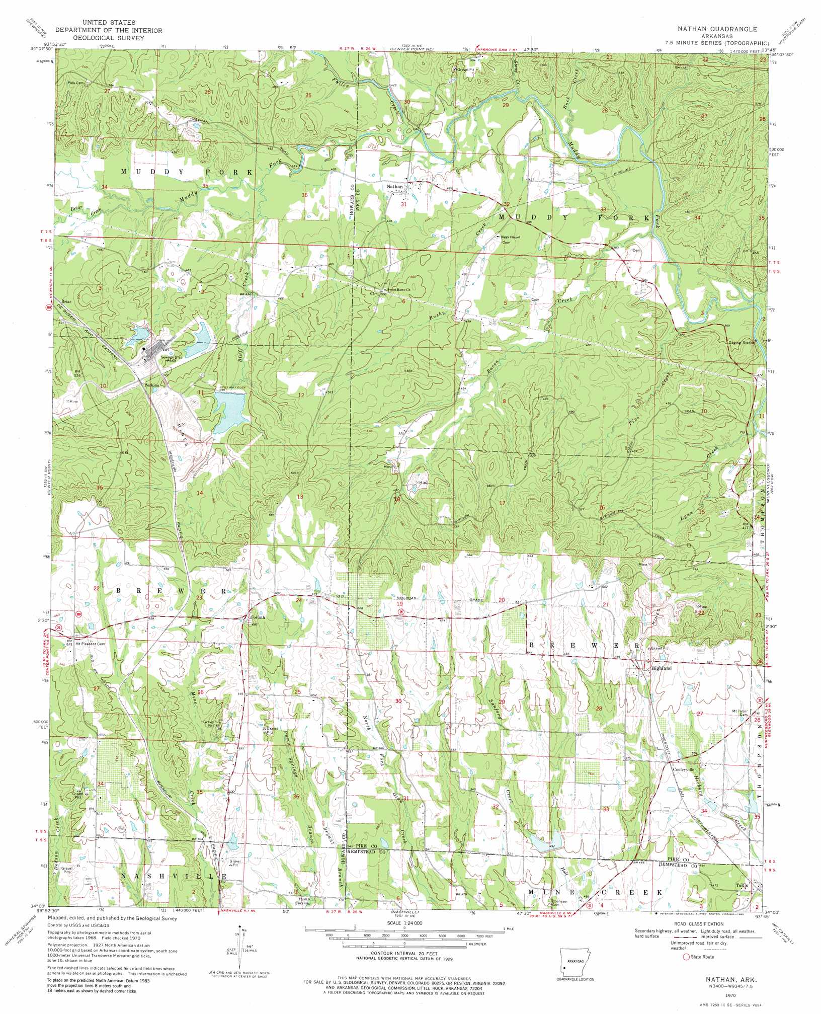
USGS Topo Quad 34093a7 - 1:24,000 scale
| Topo Map Name: | Nathan |
| USGS Topo Quad ID: | 34093a7 |
| Print Size: | ca. 21 1/4" wide x 27" high |
| Southeast Coordinates: | 34° N latitude / 93.75° W longitude |
| Map Center Coordinates: | 34.0625° N latitude / 93.8125° W longitude |
| U.S. State: | AR |
| Filename: | o34093a7.jpg |
| Download Map JPG Image: | Nathan topo map 1:24,000 scale |
| Map Type: | Topographic |
| Topo Series: | 7.5´ |
| Map Scale: | 1:24,000 |
| Source of Map Images: | United States Geological Survey (USGS) |
| Alternate Map Versions: |
Nathan AR 1970, updated 1972 Download PDF Buy paper map Nathan AR 1970, updated 1980 Download PDF Buy paper map Nathan AR 2011 Download PDF Buy paper map Nathan AR 2014 Download PDF Buy paper map |
1:24,000 Topo Quads surrounding Nathan
Umpire |
Athens |
Langley |
Lodi |
Glenwood |
Dierks Dam |
Newhope |
Center Point Ne |
Narrows Dam |
Murfreesboro Ne |
Dierks |
Center Point |
Nathan |
Murfreesboro |
Delight |
Silver Ridge |
Mineral Springs North |
Nashville |
Mccaskill |
Pisgah |
Ben Lomond |
Mineral Springs South |
Columbus |
Washington |
Blevins |
> Back to 34093a1 at 1:100,000 scale
> Back to 34092a1 at 1:250,000 scale
> Back to U.S. Topo Maps home
Nathan topo map: Gazetteer
Nathan: Dams
Briar Plant Lake One Dam elevation 139m 456′Briar Plant Lake Three Dam elevation 151m 495′
Briar Plant Lake Two Dam elevation 153m 501′
Davis Lake Dam elevation 171m 561′
McClure Lake Dam elevation 175m 574′
North Fork Ozan Creek Site Four Dam elevation 154m 505′
North Fork Ozan Creek Site One Dam elevation 154m 505′
North Fork Ozan Creek Site Two Dam elevation 152m 498′
Teeter Lake Dam elevation 158m 518′
Tetter Lake Two Dam elevation 156m 511′
Nathan: Populated Places
Briar elevation 145m 475′Cooleyville elevation 175m 574′
Corinth elevation 199m 652′
Highland elevation 179m 587′
Nathan elevation 122m 400′
Norvelle (historical) elevation 112m 367′
Perkins elevation 164m 538′
Pump Springs (historical) elevation 164m 538′
Reed elevation 153m 501′
Tokio elevation 147m 482′
Nathan: Reservoirs
Briar Plant Lake One elevation 139m 456′Briar Plant Lake Three elevation 151m 495′
Briar Plant Lake Two elevation 153m 501′
Davis Lake elevation 171m 561′
McClure Lake elevation 175m 574′
North Fork Ozan Creek Site Four Reservoir elevation 154m 505′
North Fork Ozan Creek Watershed Number One Reservoir elevation 154m 505′
North Fork Ozan Creek Wateshed Number Two Reservoir elevation 152m 498′
Teeter Lake elevation 158m 518′
Tetter Lake Two elevation 156m 511′
Nathan: Springs
Pump Spring elevation 154m 505′Nathan: Streams
Bacon Creek elevation 110m 360′Bluff Creek elevation 124m 406′
Briar Creek elevation 130m 426′
Brushy Creek elevation 116m 380′
Buck Creek elevation 112m 367′
Fallen Creek elevation 118m 387′
Lynn Creek elevation 106m 347′
Pine Creek elevation 111m 364′
Sanford Creek elevation 155m 508′
Stony Creek elevation 115m 377′
Nathan: Trails
Gypsum Trail elevation 173m 567′Kizzia Trail elevation 140m 459′
Nathan digital topo map on disk
Buy this Nathan topo map showing relief, roads, GPS coordinates and other geographical features, as a high-resolution digital map file on DVD: