Murfreesboro Ne Topo Map Arkansas
To zoom in, hover over the map of Murfreesboro Ne
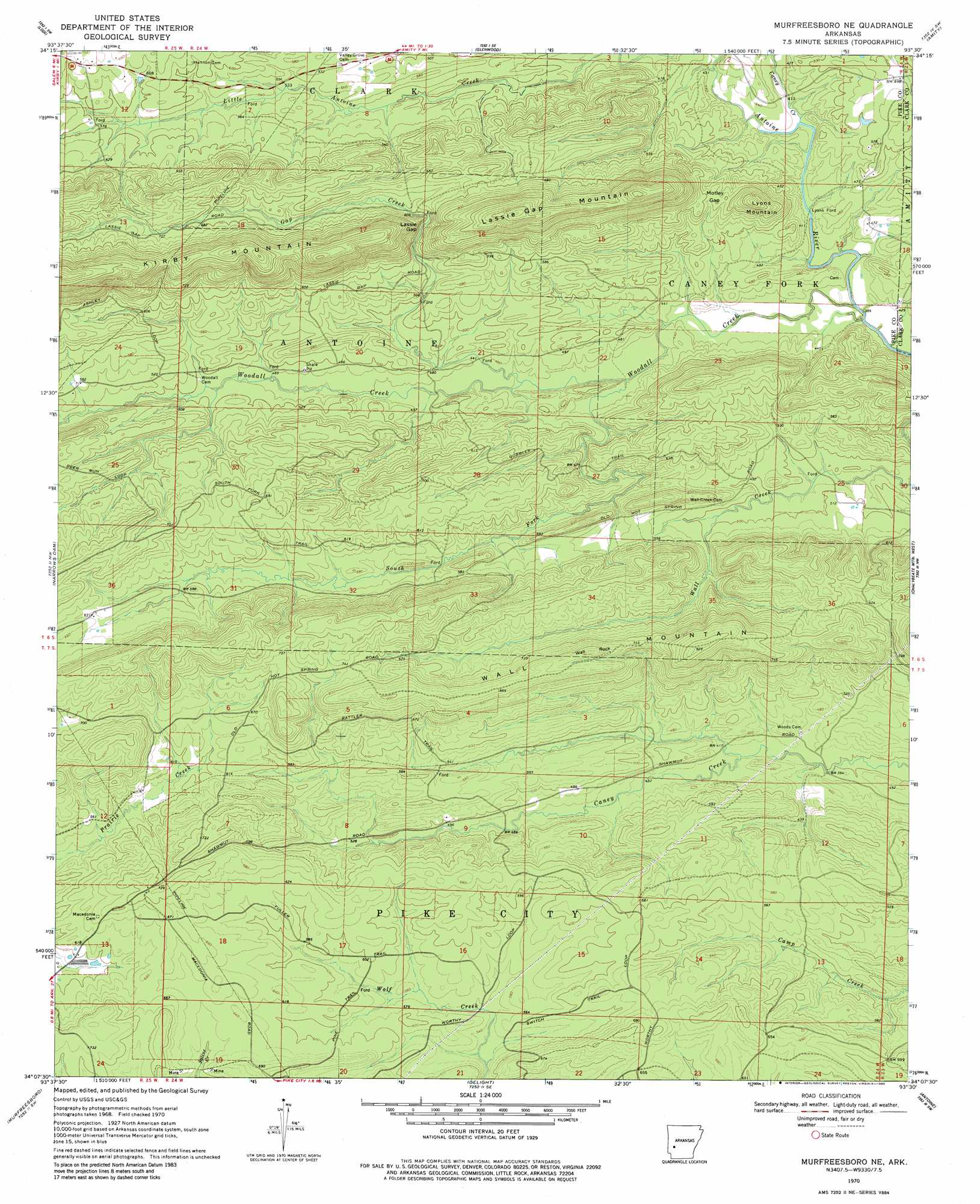
USGS Topo Quad 34093b5 - 1:24,000 scale
| Topo Map Name: | Murfreesboro Ne |
| USGS Topo Quad ID: | 34093b5 |
| Print Size: | ca. 21 1/4" wide x 27" high |
| Southeast Coordinates: | 34.125° N latitude / 93.5° W longitude |
| Map Center Coordinates: | 34.1875° N latitude / 93.5625° W longitude |
| U.S. State: | AR |
| Filename: | o34093b5.jpg |
| Download Map JPG Image: | Murfreesboro Ne topo map 1:24,000 scale |
| Map Type: | Topographic |
| Topo Series: | 7.5´ |
| Map Scale: | 1:24,000 |
| Source of Map Images: | United States Geological Survey (USGS) |
| Alternate Map Versions: |
Murfreesboro NE AR 1970, updated 1972 Download PDF Buy paper map Murfreesboro NE AR 1970, updated 1980 Download PDF Buy paper map Murfreesboro NE AR 2011 Download PDF Buy paper map Murfreesboro NE AR 2014 Download PDF Buy paper map |
1:24,000 Topo Quads surrounding Murfreesboro Ne
Polk Creek Mountain |
Norman |
Caddo Gap |
Bonnerdale |
Pearcy |
Langley |
Lodi |
Glenwood |
Amity |
Point Cedar |
Center Point Ne |
Narrows Dam |
Murfreesboro Ne |
Chalybeate Mountain West |
Chalybeate Mountain East |
Nathan |
Murfreesboro |
Delight |
Antoine |
Okolona North |
Nashville |
Mccaskill |
Pisgah |
Piney Grove |
Okolona South |
> Back to 34093a1 at 1:100,000 scale
> Back to 34092a1 at 1:250,000 scale
> Back to U.S. Topo Maps home
Murfreesboro Ne topo map: Gazetteer
Murfreesboro Ne: Cliffs
Wall Rock elevation 234m 767′Murfreesboro Ne: Gaps
Lassie Gap elevation 184m 603′Motley Gap elevation 183m 600′
Murfreesboro Ne: Populated Places
Anderson (historical) elevation 130m 426′Elk (historical) elevation 128m 419′
Lissie (historical) elevation 198m 649′
Rabell (historical) elevation 208m 682′
Wright (historical) elevation 140m 459′
Murfreesboro Ne: Ridges
Kirby Mountain elevation 335m 1099′Wall Mountain elevation 240m 787′
Murfreesboro Ne: Streams
Caney Creek elevation 128m 419′Gap Creek elevation 131m 429′
South Fork Woodall Creek elevation 131m 429′
Woodall Creek elevation 123m 403′
Murfreesboro Ne: Summits
Lassie Gap Mountain elevation 319m 1046′Lyons Mountain elevation 234m 767′
Murfreesboro Ne digital topo map on disk
Buy this Murfreesboro Ne topo map showing relief, roads, GPS coordinates and other geographical features, as a high-resolution digital map file on DVD: