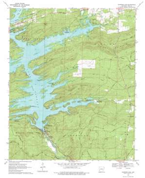
Narrows Dam Topo Map Arkansas
To zoom in, hover over the map of Narrows Dam
USGS Topo Quad 34093b6 - 1:24,000 scale
| Topo Map Name: | Narrows Dam |
| USGS Topo Quad ID: | 34093b6 |
| Print Size: | ca. 21 1/4" wide x 27" high |
| Southeast Coordinates: | 34.125° N latitude / 93.625° W longitude |
| Map Center Coordinates: | 34.1875° N latitude / 93.6875° W longitude |
| U.S. State: | AR |
| Filename: | o34093b6.jpg |
| Download Map JPG Image: | Narrows Dam topo map 1:24,000 scale |
| Map Type: | Topographic |
| Topo Series: | 7.5´ |
| Map Scale: | 1:24,000 |
| Source of Map Images: | United States Geological Survey (USGS) |
| Alternate Map Versions: |
Narrows Dam AR 1969, updated 1972 Download PDF Buy paper map Narrows Dam AR 1969, updated 1977 Download PDF Buy paper map Narrows Dam AR 1980, updated 1982 Download PDF Buy paper map Narrows Dam AR 1980, updated 1986 Download PDF Buy paper map Narrows Dam AR 2011 Download PDF Buy paper map Narrows Dam AR 2014 Download PDF Buy paper map |
1:24,000 Topo Quads surrounding Narrows Dam
> Back to 34093a1 at 1:100,000 scale
> Back to 34092a1 at 1:250,000 scale
> Back to U.S. Topo Maps home
Narrows Dam topo map: Gazetteer
Narrows Dam: Cliffs
Hinds Bluff elevation 122m 400′Narrows Dam: Dams
Lake Greeson Nursery Pond Dam elevation 167m 547′Narrows Dam elevation 147m 482′
Narrows Dam: Parks
Bear Creek Public Use Area elevation 177m 580′Cowhide Cove Public Use Area elevation 166m 544′
Daisy State Park elevation 186m 610′
Kirby Landing Public Use Area elevation 173m 567′
Laurel Creek Public Use Area elevation 178m 583′
Narrows Dam Public Use Area elevation 180m 590′
Parker Creek Public Use Area elevation 171m 561′
Pikeville Public Use Area elevation 175m 574′
Riverside Picnic Area elevation 130m 426′
Narrows Dam: Pillars
Chimney Rock elevation 165m 541′Narrows Dam: Populated Places
Abner (historical) elevation 163m 534′Daisy elevation 190m 623′
Helbig (historical) elevation 182m 597′
Stanley (historical) elevation 185m 606′
Narrows Dam: Post Offices
Kirby Post Office elevation 203m 666′Narrows Dam: Reservoirs
Lake Greeson elevation 147m 482′Lake Greeson Nursery Pond elevation 167m 547′
Narrows Dam: Streams
Bear Creek elevation 165m 541′Cowhide Creek elevation 167m 547′
Daisy Creek elevation 171m 561′
Laurel Creek elevation 165m 541′
North Hog Creek elevation 164m 538′
Parker Creek elevation 169m 554′
Ponder Creek elevation 167m 547′
Rough Branch elevation 168m 551′
School Creek elevation 172m 564′
Skelton Creek elevation 162m 531′
South Hog Creek elevation 164m 538′
Narrows Dam: Summits
Beacon Hill elevation 234m 767′Dynamite Hill elevation 224m 734′
Funderburk Mountain elevation 253m 830′
Mill Mountain elevation 224m 734′
Round Top elevation 275m 902′
Skelton Mountain elevation 274m 898′
Narrows Dam digital topo map on disk
Buy this Narrows Dam topo map showing relief, roads, GPS coordinates and other geographical features, as a high-resolution digital map file on DVD:


