Center Point Ne Topo Map Arkansas
To zoom in, hover over the map of Center Point Ne
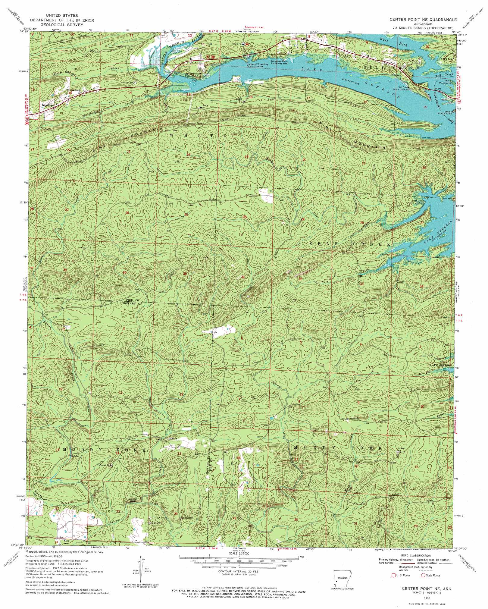
USGS Topo Quad 34093b7 - 1:24,000 scale
| Topo Map Name: | Center Point Ne |
| USGS Topo Quad ID: | 34093b7 |
| Print Size: | ca. 21 1/4" wide x 27" high |
| Southeast Coordinates: | 34.125° N latitude / 93.75° W longitude |
| Map Center Coordinates: | 34.1875° N latitude / 93.8125° W longitude |
| U.S. State: | AR |
| Filename: | o34093b7.jpg |
| Download Map JPG Image: | Center Point Ne topo map 1:24,000 scale |
| Map Type: | Topographic |
| Topo Series: | 7.5´ |
| Map Scale: | 1:24,000 |
| Source of Map Images: | United States Geological Survey (USGS) |
| Alternate Map Versions: |
Center Point NE AR 1970, updated 1972 Download PDF Buy paper map Center Point NE AR 2011 Download PDF Buy paper map Center Point NE AR 2014 Download PDF Buy paper map |
1:24,000 Topo Quads surrounding Center Point Ne
Nichols Nountain |
Big Fork |
Polk Creek Mountain |
Norman |
Caddo Gap |
Umpire |
Athens |
Langley |
Lodi |
Glenwood |
Dierks Dam |
Newhope |
Center Point Ne |
Narrows Dam |
Murfreesboro Ne |
Dierks |
Center Point |
Nathan |
Murfreesboro |
Delight |
Silver Ridge |
Mineral Springs North |
Nashville |
Mccaskill |
Pisgah |
> Back to 34093a1 at 1:100,000 scale
> Back to 34092a1 at 1:250,000 scale
> Back to U.S. Topo Maps home
Center Point Ne topo map: Gazetteer
Center Point Ne: Bays
West Fork Lake Greeson elevation 165m 541′Center Point Ne: Cliffs
Wildcat Bluff elevation 136m 446′Center Point Ne: Parks
Arrowhead Point Public Use Area elevation 177m 580′Highway 70 Landing Public Use Area elevation 168m 551′
Rock Creek Public Use Area elevation 165m 541′
Self Creek Public Use Area elevation 182m 597′
Star of the West Public Use Area elevation 176m 577′
Wylie Picnic Area elevation 176m 577′
Center Point Ne: Populated Places
Crawford (historical) elevation 220m 721′Star of the West (historical) elevation 178m 583′
Center Point Ne: Streams
Blue Creek elevation 171m 561′Brickyard Creek elevation 169m 554′
Jacobs Creek elevation 132m 433′
Little Creek elevation 171m 561′
Panther Creek elevation 145m 475′
Rock Creek elevation 167m 547′
West Fork elevation 164m 538′
White Oak Creek elevation 169m 554′
Center Point Ne: Summits
Pine Mountain elevation 271m 889′Center Point Ne digital topo map on disk
Buy this Center Point Ne topo map showing relief, roads, GPS coordinates and other geographical features, as a high-resolution digital map file on DVD: