Big Fork Topo Map Arkansas
To zoom in, hover over the map of Big Fork
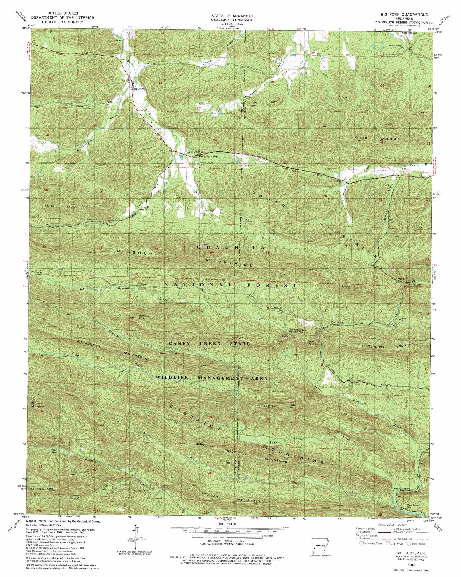
USGS Topo Quad 34093d8 - 1:24,000 scale
| Topo Map Name: | Big Fork |
| USGS Topo Quad ID: | 34093d8 |
| Print Size: | ca. 21 1/4" wide x 27" high |
| Southeast Coordinates: | 34.375° N latitude / 93.875° W longitude |
| Map Center Coordinates: | 34.4375° N latitude / 93.9375° W longitude |
| U.S. State: | AR |
| Filename: | o34093d8.jpg |
| Download Map JPG Image: | Big Fork topo map 1:24,000 scale |
| Map Type: | Topographic |
| Topo Series: | 7.5´ |
| Map Scale: | 1:24,000 |
| Source of Map Images: | United States Geological Survey (USGS) |
| Alternate Map Versions: |
Big Fork AR 1980, updated 1981 Download PDF Buy paper map Big Fork AR 2011 Download PDF Buy paper map Big Fork AR 2014 Download PDF Buy paper map |
| FStopo: | US Forest Service topo Big Fork is available: Download FStopo PDF Download FStopo TIF |
1:24,000 Topo Quads surrounding Big Fork
Acorn |
Y City |
Buck Knob |
Bushy Creek Mountain |
Sims |
Mena |
Board Camp |
Pine Ridge |
Oden |
Mount Ida |
Eagle Mountain |
Nichols Nountain |
Big Fork |
Polk Creek Mountain |
Norman |
Baker Springs |
Umpire |
Athens |
Langley |
Lodi |
Gillham Dam |
Dierks Dam |
Newhope |
Center Point Ne |
Narrows Dam |
> Back to 34093a1 at 1:100,000 scale
> Back to 34092a1 at 1:250,000 scale
> Back to U.S. Topo Maps home
Big Fork topo map: Gazetteer
Big Fork: Gaps
Mosquito Gap elevation 520m 1706′Big Fork: Parks
Little Missouri Falls Recreation Area elevation 360m 1181′Big Fork: Populated Places
Big Fork elevation 309m 1013′Sulphur Springs elevation 293m 961′
Big Fork: Ridges
Brier Creek Mountains elevation 469m 1538′Cossatot Mountains elevation 446m 1463′
McKinley Mountain elevation 598m 1961′
Missouri Mountains elevation 641m 2103′
Statehouse Mountain elevation 564m 1850′
Big Fork: Springs
Abernathy Spring elevation 335m 1099′Alpine Spring elevation 332m 1089′
Big Fork: Streams
Brier Creek elevation 281m 921′Butcherknife Creek elevation 308m 1010′
Crooked Creek elevation 359m 1177′
Dry Creek elevation 335m 1099′
Long Creek elevation 295m 967′
Straight Creek elevation 354m 1161′
Wehunt Creek elevation 334m 1095′
Big Fork: Summits
Hurricane Knob elevation 650m 2132′Leader Mountain elevation 495m 1624′
Lick Mountain elevation 410m 1345′
Raspberry Mountain elevation 686m 2250′
Round Mountain elevation 521m 1709′
Sugartree Mountain elevation 616m 2020′
Turners Mountain elevation 369m 1210′
Big Fork digital topo map on disk
Buy this Big Fork topo map showing relief, roads, GPS coordinates and other geographical features, as a high-resolution digital map file on DVD: