Toblerville Topo Map Oklahoma
To zoom in, hover over the map of Toblerville
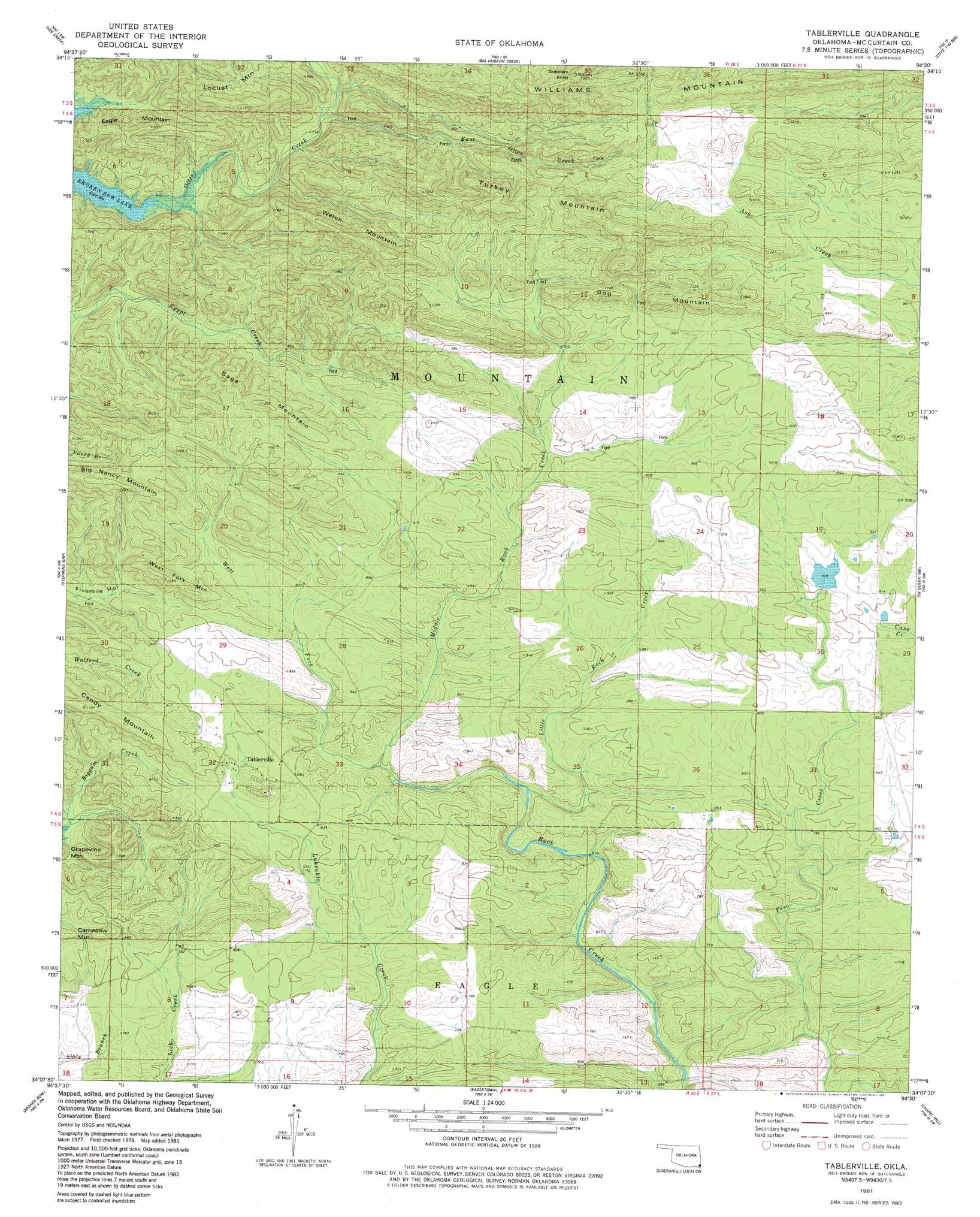
USGS Topo Quad 34094b5 - 1:24,000 scale
| Topo Map Name: | Toblerville |
| USGS Topo Quad ID: | 34094b5 |
| Print Size: | ca. 21 1/4" wide x 27" high |
| Southeast Coordinates: | 34.125° N latitude / 94.5° W longitude |
| Map Center Coordinates: | 34.1875° N latitude / 94.5625° W longitude |
| U.S. State: | OK |
| Filename: | o34094b5.jpg |
| Download Map JPG Image: | Toblerville topo map 1:24,000 scale |
| Map Type: | Topographic |
| Topo Series: | 7.5´ |
| Map Scale: | 1:24,000 |
| Source of Map Images: | United States Geological Survey (USGS) |
| Alternate Map Versions: |
Tablerville OK 1981, updated 1981 Download PDF Buy paper map Tablerville OK 2010 Download PDF Buy paper map Tablerville OK 2013 Download PDF Buy paper map Tablerville OK 2016 Download PDF Buy paper map |
| FStopo: | US Forest Service topo Tablerville is available: Download FStopo PDF Download FStopo TIF |
1:24,000 Topo Quads surrounding Toblerville
White Rock Mountain |
Smithville |
Watson |
Cove |
Vandervoort |
Bethel |
Hee Creek |
Big Hudson Creek |
Bog Springs |
Wickes |
Old Glory Mountain |
Stephens Gap |
Toblerville |
De Queen Nw |
Gillham |
Steel Junction |
Broken Bow |
Eagletown |
Chapel Hill |
De Queen |
Idabel |
Shults |
Goodwater |
Cerrogordo |
Horatio |
> Back to 34094a1 at 1:100,000 scale
> Back to 34094a1 at 1:250,000 scale
> Back to U.S. Topo Maps home
Toblerville topo map: Gazetteer
Toblerville: Dams
Henderson Lake Dam elevation 294m 964′Toblerville: Reservoirs
Henderson Lake elevation 294m 964′Toblerville: Streams
East Otter Creek elevation 217m 711′Little Rock Creek elevation 197m 646′
Luksuklo Creek elevation 262m 859′
Middle Rock Creek elevation 199m 652′
West Fork Middle Rock Creek elevation 213m 698′
Toblerville: Summits
Big Nancy Mountain elevation 374m 1227′Bog Mountain elevation 374m 1227′
Eagle Mountain elevation 303m 994′
Gobblers Knob elevation 452m 1482′
Hochatown Mountain elevation 322m 1056′
Kennedy Mountain elevation 328m 1076′
Sage Mountain elevation 362m 1187′
Turkey Mountain elevation 424m 1391′
Welch Mountain elevation 404m 1325′
West Fork Mountain elevation 327m 1072′
Williams Mountain elevation 452m 1482′
Toblerville digital topo map on disk
Buy this Toblerville topo map showing relief, roads, GPS coordinates and other geographical features, as a high-resolution digital map file on DVD: