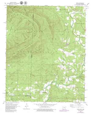
Zafra Topo Map Arkansas
To zoom in, hover over the map of Zafra
USGS Topo Quad 34094e4 - 1:24,000 scale
| Topo Map Name: | Zafra |
| USGS Topo Quad ID: | 34094e4 |
| Print Size: | ca. 21 1/4" wide x 27" high |
| Southeast Coordinates: | 34.5° N latitude / 94.375° W longitude |
| Map Center Coordinates: | 34.5625° N latitude / 94.4375° W longitude |
| U.S. States: | AR, OK |
| Filename: | o34094e4.jpg |
| Download Map JPG Image: | Zafra topo map 1:24,000 scale |
| Map Type: | Topographic |
| Topo Series: | 7.5´ |
| Map Scale: | 1:24,000 |
| Source of Map Images: | United States Geological Survey (USGS) |
| Alternate Map Versions: |
Zafra OK 1958, updated 1959 Download PDF Buy paper map Zafra OK 1958, updated 1959 Download PDF Buy paper map Zafra OK 1958, updated 1975 Download PDF Buy paper map Zafra OK 1958, updated 1979 Download PDF Buy paper map Zafra OK 2011 Download PDF Buy paper map Zafra OK 2013 Download PDF Buy paper map Zafra OK 2016 Download PDF Buy paper map |
| FStopo: | US Forest Service topo Zafra is available: Download FStopo PDF Download FStopo TIF |
1:24,000 Topo Quads surrounding Zafra
> Back to 34094e1 at 1:100,000 scale
> Back to 34094a1 at 1:250,000 scale
> Back to U.S. Topo Maps home
Zafra topo map: Gazetteer
Zafra: Bridges
Mountain Fork Bridge elevation 258m 846′Zafra: Dams
Ivey Lake Dam elevation 296m 971′Zafra: Populated Places
West Valley elevation 263m 862′Zafra elevation 256m 839′
Zafra: Reservoirs
Ivey Lake elevation 296m 971′Zafra: Ridges
Cedar Mountain elevation 648m 2125′Cow Creek Mountain elevation 711m 2332′
Turkey Snout Ridge elevation 597m 1958′
Zafra: Streams
Calvin Branch elevation 281m 921′Cedar Creek elevation 268m 879′
Cedar Creek elevation 262m 859′
Choctaw Creek elevation 247m 810′
Joshling Creek elevation 253m 830′
Little Cow Creek elevation 263m 862′
Mill Creek elevation 282m 925′
Mill Creek elevation 284m 931′
Murry Creek elevation 246m 807′
Nancy Branch elevation 258m 846′
Pollock Branch elevation 266m 872′
Powell Creek elevation 273m 895′
Queen Creek elevation 285m 935′
Rock Creek elevation 260m 853′
Slate Creek elevation 254m 833′
Slate Creek elevation 255m 836′
Turkey Snout Creek elevation 431m 1414′
Twomile Creek elevation 262m 859′
Zafra: Summits
Cow Creek Mountain elevation 636m 2086′Little Cow Mountain elevation 532m 1745′
Little Round Mountain elevation 615m 2017′
Phillips Mountain elevation 656m 2152′
Polecat Peak elevation 732m 2401′
Round Mountain elevation 659m 2162′
Round Mountain elevation 661m 2168′
Walnut Mountain elevation 720m 2362′
Zafra digital topo map on disk
Buy this Zafra topo map showing relief, roads, GPS coordinates and other geographical features, as a high-resolution digital map file on DVD:


