Leflore Se Topo Map Oklahoma
To zoom in, hover over the map of Leflore Se
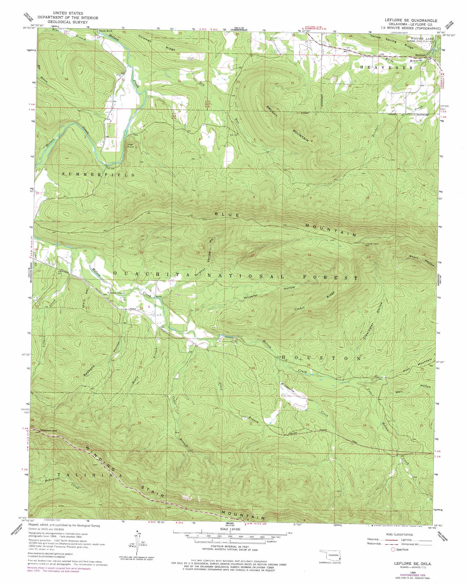
USGS Topo Quad 34094g7 - 1:24,000 scale
| Topo Map Name: | Leflore Se |
| USGS Topo Quad ID: | 34094g7 |
| Print Size: | ca. 21 1/4" wide x 27" high |
| Southeast Coordinates: | 34.75° N latitude / 94.75° W longitude |
| Map Center Coordinates: | 34.8125° N latitude / 94.8125° W longitude |
| U.S. State: | OK |
| Filename: | o34094g7.jpg |
| Download Map JPG Image: | Leflore Se topo map 1:24,000 scale |
| Map Type: | Topographic |
| Topo Series: | 7.5´ |
| Map Scale: | 1:24,000 |
| Source of Map Images: | United States Geological Survey (USGS) |
| Alternate Map Versions: |
Leflore SE OK 1966, updated 1967 Download PDF Buy paper map Leflore SE OK 1966, updated 1978 Download PDF Buy paper map Leflore SE OK 2011 Download PDF Buy paper map Leflore SE OK 2012 Download PDF Buy paper map Leflore SE OK 2016 Download PDF Buy paper map |
| FStopo: | US Forest Service topo Leflore SE is available: Download FStopo PDF Download FStopo TIF |
1:24,000 Topo Quads surrounding Leflore Se
Lequire |
Mccurtain Sw |
Potato Peaks |
Poteau West |
Poteau East |
Red Oak |
Leflore |
Summerfield |
Wister |
Heavener |
Talihina |
Blackjack Ridge |
Leflore Se |
Hodgens |
Hontubby |
Albion |
Whitesboro |
Muse |
Big Cedar |
Page |
Albion Se |
Honobia |
Ludlow |
Octavia |
Lynn Mountain |
> Back to 34094e1 at 1:100,000 scale
> Back to 34094a1 at 1:250,000 scale
> Back to U.S. Topo Maps home
Leflore Se topo map: Gazetteer
Leflore Se: Gaps
Deadman Gap elevation 485m 1591′Leflore Se: Parks
Indian Nations National Scenic and Wildlife Area elevation 244m 800′Leflore Se: Populated Places
Reichert elevation 156m 511′Leflore Se: Ridges
Clebit Ridge elevation 455m 1492′Coleman Ridge elevation 226m 741′
Leflore Se: Streams
Allen Branch elevation 209m 685′Britton Branch elevation 159m 521′
Cedar Branch elevation 208m 682′
Dry Run elevation 159m 521′
Lillard Creek elevation 188m 616′
Negro Branch elevation 206m 675′
Upper Holson Creek elevation 239m 784′
White Branch elevation 152m 498′
Wildhorse Creek elevation 222m 728′
Leflore Se: Summits
Blue Mountain elevation 605m 1984′Brushy Mountain elevation 354m 1161′
High Point elevation 239m 784′
Leflore Se: Valleys
Clearwater Hollow elevation 239m 784′Redbank Hollow elevation 207m 679′
Stark Hollow elevation 192m 629′
Sulphur Spring Hollow elevation 204m 669′
Well Hollow elevation 246m 807′
Wheeler Hollow elevation 211m 692′
Leflore Se digital topo map on disk
Buy this Leflore Se topo map showing relief, roads, GPS coordinates and other geographical features, as a high-resolution digital map file on DVD: