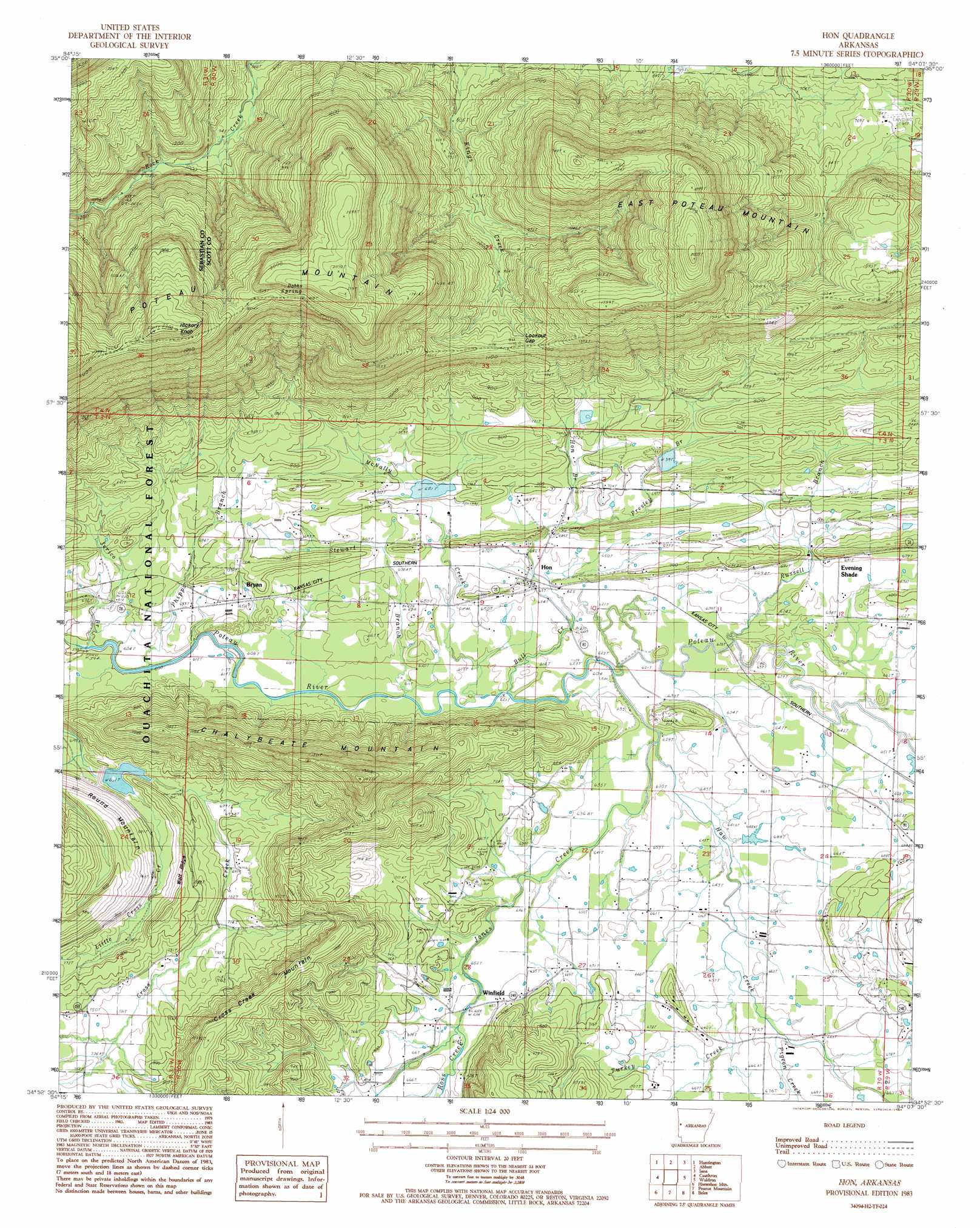
Hon Topo Map Arkansas
To zoom in, hover over the map of Hon
USGS Topo Quad 34094h2 - 1:24,000 scale
| Topo Map Name: | Hon |
| USGS Topo Quad ID: | 34094h2 |
| Print Size: | ca. 21 1/4" wide x 27" high |
| Southeast Coordinates: | 34.875° N latitude / 94.125° W longitude |
| Map Center Coordinates: | 34.9375° N latitude / 94.1875° W longitude |
| U.S. State: | AR |
| Filename: | o34094h2.jpg |
| Download Map JPG Image: | Hon topo map 1:24,000 scale |
| Map Type: | Topographic |
| Topo Series: | 7.5´ |
| Map Scale: | 1:24,000 |
| Source of Map Images: | United States Geological Survey (USGS) |
| Alternate Map Versions: |
Hon AR 1983, updated 1984 Download PDF Buy paper map Hon AR 2011 Download PDF Buy paper map Hon AR 2014 Download PDF Buy paper map |
| FStopo: | US Forest Service topo Hon is available: Download FStopo PDF Download FStopo TIF |
1:24,000 Topo Quads surrounding Hon
Hackett |
Greenwood |
Burnville |
Barber |
Booneville |
Hartford |
Huntington |
Abbott |
Ione |
Golden City |
Bates |
Cauthron |
Hon |
Waldron |
Bee Mountain |
Loving |
Horseshoe Mountain |
Peanut Mountain |
Boles |
Parks |
Mountain Fork |
Rich Mountain |
Acorn |
Y City |
Buck Knob |
> Back to 34094e1 at 1:100,000 scale
> Back to 34094a1 at 1:250,000 scale
> Back to U.S. Topo Maps home
Hon topo map: Gazetteer
Hon: Airports
Arkansas Western Landing Strip elevation 226m 741′Hon: Dams
Arkansas Noname 153 Dam elevation 208m 682′Poteau River Watershed Site 16 Dam elevation 200m 656′
Poteau River Watershed Site Eight Dam elevation 206m 675′
Hon: Gaps
Lookout Gap elevation 357m 1171′Hon: Populated Places
Bryan elevation 201m 659′Evening Shade elevation 216m 708′
Hon elevation 190m 623′
Winfield elevation 199m 652′
Hon: Reservoirs
Poteau River Site Seven Lake elevation 208m 682′Poteau River Watershed Site 16 Lake elevation 200m 656′
Poteau River Watershed Site Eight Lake elevation 206m 675′
Hon: Ridges
Wolf Ridge elevation 265m 869′Hon: Springs
Dobbs Spring elevation 570m 1870′Hon: Streams
Bull Creek elevation 188m 616′Haw Creek elevation 190m 623′
Hon Branch elevation 187m 613′
Jones Creek elevation 193m 633′
Little Cross Creek elevation 200m 656′
McNally Creek elevation 198m 649′
Phipps Branch elevation 184m 603′
Pigeon Creek elevation 197m 646′
Presley Branch elevation 197m 646′
Ross Creek elevation 198m 649′
Russell Branch elevation 192m 629′
Stewart Branch elevation 191m 626′
Turkey Creek elevation 193m 633′
Hon: Summits
Chalybeate Mountain elevation 407m 1335′Cross Creek Mountain elevation 331m 1085′
East Poteau Mountain elevation 614m 2014′
Hickory Knob elevation 648m 2125′
Round Mountain elevation 277m 908′
Hon: Valleys
Rock Canyon elevation 287m 941′Hon digital topo map on disk
Buy this Hon topo map showing relief, roads, GPS coordinates and other geographical features, as a high-resolution digital map file on DVD: