Bates Topo Map Arkansas
To zoom in, hover over the map of Bates
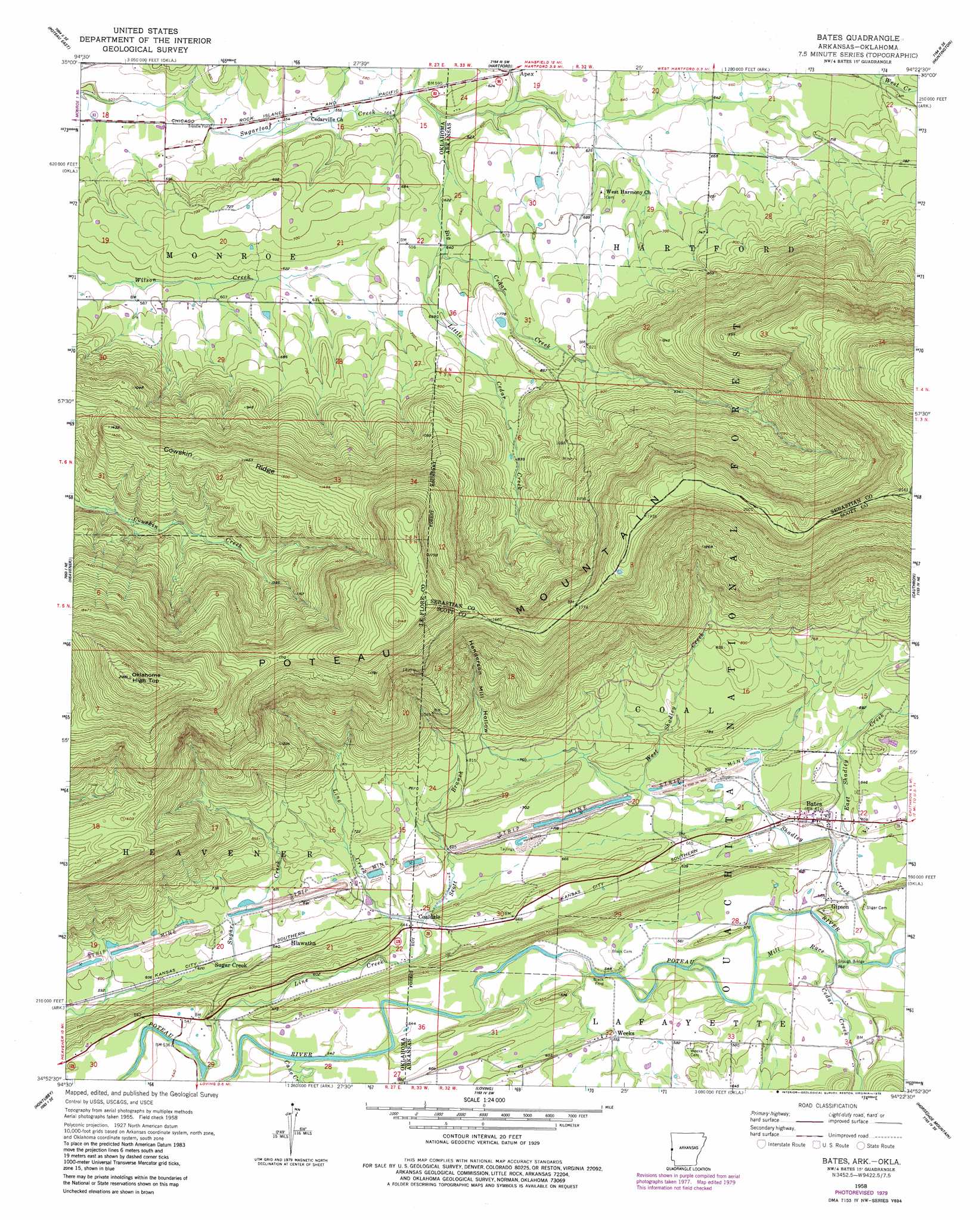
USGS Topo Quad 34094h4 - 1:24,000 scale
| Topo Map Name: | Bates |
| USGS Topo Quad ID: | 34094h4 |
| Print Size: | ca. 21 1/4" wide x 27" high |
| Southeast Coordinates: | 34.875° N latitude / 94.375° W longitude |
| Map Center Coordinates: | 34.9375° N latitude / 94.4375° W longitude |
| U.S. States: | AR, OK |
| Filename: | o34094h4.jpg |
| Download Map JPG Image: | Bates topo map 1:24,000 scale |
| Map Type: | Topographic |
| Topo Series: | 7.5´ |
| Map Scale: | 1:24,000 |
| Source of Map Images: | United States Geological Survey (USGS) |
| Alternate Map Versions: |
Bates AR 1958, updated 1959 Download PDF Buy paper map Bates AR 1958, updated 1977 Download PDF Buy paper map Bates AR 1958, updated 1979 Download PDF Buy paper map Bates AR 2011 Download PDF Buy paper map Bates AR 2014 Download PDF Buy paper map |
| FStopo: | US Forest Service topo Bates is available: Download FStopo PDF Download FStopo TIF |
1:24,000 Topo Quads surrounding Bates
Panama |
Spiro |
Hackett |
Greenwood |
Burnville |
Poteau West |
Poteau East |
Hartford |
Huntington |
Abbott |
Wister |
Heavener |
Bates |
Cauthron |
Hon |
Hodgens |
Hontubby |
Loving |
Horseshoe Mountain |
Peanut Mountain |
Big Cedar |
Page |
Mountain Fork |
Rich Mountain |
Acorn |
> Back to 34094e1 at 1:100,000 scale
> Back to 34094a1 at 1:250,000 scale
> Back to U.S. Topo Maps home
Bates topo map: Gazetteer
Bates: Bridges
Slough Bridge elevation 174m 570′Bates: Canals
Mill Race elevation 174m 570′Bates: Populated Places
Apex elevation 186m 610′Bates elevation 189m 620′
Coaldale elevation 197m 646′
Gipson elevation 180m 590′
Hiawatha elevation 196m 643′
Sugar Creek elevation 189m 620′
Trestle Ford elevation 159m 521′
Weeks elevation 172m 564′
Bates: Post Offices
Bates Post Office elevation 187m 613′Bates: Ridges
Cowskin Ridge elevation 445m 1459′Bates: Streams
Big Cedar Creek elevation 190m 623′Big Cedar Creek elevation 177m 580′
Cane Creek elevation 162m 531′
Cedar Creek elevation 172m 564′
East Shadley Creek elevation 178m 583′
Line Creek elevation 158m 518′
Little Cedar Creek elevation 198m 649′
Little Cedar Creek elevation 194m 636′
Scott Branch elevation 201m 659′
Shadley Creek elevation 170m 557′
West Shadley Creek elevation 190m 623′
Bates: Summits
Oklahoma High Top elevation 727m 2385′Bates: Valleys
Henderson Mill Hollow elevation 246m 807′Bates digital topo map on disk
Buy this Bates topo map showing relief, roads, GPS coordinates and other geographical features, as a high-resolution digital map file on DVD: